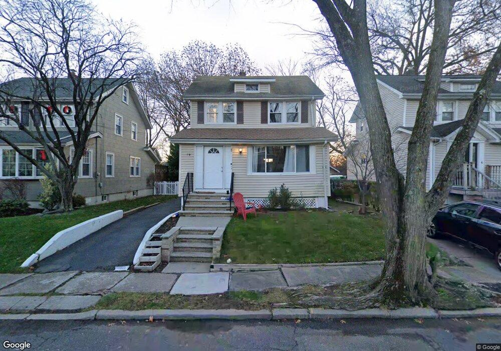
19 Beverly Rd Oradell, NJ 07649
Estimated Value: $555,000 - $718,000
3
Beds
2
Baths
1,133
Sq Ft
$558/Sq Ft
Est. Value
About This Home
This home is located at 19 Beverly Rd, Oradell, NJ 07649 and is currently estimated at $632,162, approximately $557 per square foot. 19 Beverly Rd is a home located in Bergen County with nearby schools including Oradell Elementary School, River Dell Middle School, and River Dell Regional High School.
Ownership History
Date
Name
Owned For
Owner Type
Purchase Details
Closed on
Mar 30, 2020
Sold by
Fannie Mae
Bought by
Hart Jon Henry
Current Estimated Value
Home Financials for this Owner
Home Financials are based on the most recent Mortgage that was taken out on this home.
Original Mortgage
$377,000
Outstanding Balance
$334,604
Interest Rate
3.5%
Mortgage Type
New Conventional
Estimated Equity
$297,558
Purchase Details
Closed on
Nov 28, 2017
Sold by
Saudino Michael
Bought by
Federal National Mortgage Association
Purchase Details
Closed on
Sep 1, 2005
Sold by
Cook Thomas
Bought by
Kim Eun Ok
Home Financials for this Owner
Home Financials are based on the most recent Mortgage that was taken out on this home.
Original Mortgage
$340,000
Interest Rate
5.79%
Create a Home Valuation Report for This Property
The Home Valuation Report is an in-depth analysis detailing your home's value as well as a comparison with similar homes in the area
Home Values in the Area
Average Home Value in this Area
Purchase History
| Date | Buyer | Sale Price | Title Company |
|---|---|---|---|
| Hart Jon Henry | $397,500 | Catic Title Insurance Co | |
| Federal National Mortgage Association | -- | -- | |
| Kim Eun Ok | $425,000 | -- |
Source: Public Records
Mortgage History
| Date | Status | Borrower | Loan Amount |
|---|---|---|---|
| Open | Hart Jon Henry | $377,000 | |
| Previous Owner | Kim Eun Ok | $340,000 |
Source: Public Records
Tax History
| Year | Tax Paid | Tax Assessment Tax Assessment Total Assessment is a certain percentage of the fair market value that is determined by local assessors to be the total taxable value of land and additions on the property. | Land | Improvement |
|---|---|---|---|---|
| 2025 | $10,913 | $522,600 | $337,000 | $185,600 |
| 2024 | $10,648 | $400,900 | $236,000 | $164,900 |
| 2023 | $10,177 | $399,100 | $235,000 | $164,100 |
| 2022 | $10,177 | $380,600 | $225,000 | $155,600 |
| 2021 | $10,124 | $362,100 | $213,000 | $149,100 |
| 2020 | $9,563 | $346,100 | $198,000 | $148,100 |
| 2019 | $9,314 | $334,300 | $189,000 | $145,300 |
| 2018 | $9,179 | $334,400 | $191,000 | $143,400 |
| 2017 | $8,879 | $328,600 | $188,000 | $140,600 |
| 2016 | $8,621 | $289,700 | $174,000 | $115,700 |
| 2015 | $8,433 | $289,700 | $174,000 | $115,700 |
| 2014 | $8,065 | $289,700 | $174,000 | $115,700 |
Source: Public Records
Map
Nearby Homes
- 44 Richard Ct
- 589 Fletcher Ave
- 451 Central Park Dr
- 5 Fey Place
- 7 Fey Place
- 490 Albert Place
- 13 Fey Place
- 23 Fey Place
- 21 Fey Place
- 19 Fey Place
- 33 Lincoln Ave
- 784 Kinderkamack Rd Unit 101
- 147 Pine Ave
- 652 Harvard St
- 440 Holly Ave
- 130 Washington Ave
- 640 Stockton St
- 121 Pine Ave
- 668 River Rd
- 109 Center St
Your Personal Tour Guide
Ask me questions while you tour the home.