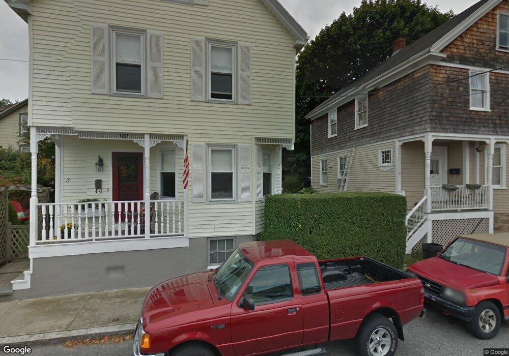
19 Central St Newport, RI 02840
Kay-Catherine NeighborhoodEstimated Value: $749,255 - $1,050,000
3
Beds
2
Baths
1,324
Sq Ft
$658/Sq Ft
Est. Value
About This Home
This home is located at 19 Central St, Newport, RI 02840 and is currently estimated at $871,064, approximately $657 per square foot. 19 Central St is a home located in Newport County with nearby schools including Rogers High School, St Michael's Country Day School, and St George's School.
Ownership History
Date
Name
Owned For
Owner Type
Purchase Details
Closed on
Aug 14, 2009
Sold by
Haskell Krista W
Bought by
Conway-Munninghoff Janis
Current Estimated Value
Purchase Details
Closed on
Oct 12, 2000
Sold by
Maguire Catherine Est
Bought by
Haskell Marc A and Haskell Krista
Create a Home Valuation Report for This Property
The Home Valuation Report is an in-depth analysis detailing your home's value as well as a comparison with similar homes in the area
Home Values in the Area
Average Home Value in this Area
Purchase History
| Date | Buyer | Sale Price | Title Company |
|---|---|---|---|
| Conway-Munninghoff Janis | $300,000 | -- | |
| Haskell Marc A | $139,000 | -- |
Source: Public Records
Mortgage History
| Date | Status | Borrower | Loan Amount |
|---|---|---|---|
| Previous Owner | Haskell Marc A | $225,000 | |
| Previous Owner | Haskell Marc A | $25,000 | |
| Previous Owner | Haskell Marc A | $137,000 | |
| Previous Owner | Haskell Marc A | $135,000 |
Source: Public Records
Tax History Compared to Growth
Tax History
| Year | Tax Paid | Tax Assessment Tax Assessment Total Assessment is a certain percentage of the fair market value that is determined by local assessors to be the total taxable value of land and additions on the property. | Land | Improvement |
|---|---|---|---|---|
| 2025 | $4,911 | $565,200 | $182,900 | $382,300 |
| 2024 | $4,646 | $565,200 | $182,900 | $382,300 |
| 2023 | $3,785 | $381,600 | $129,300 | $252,300 |
| 2022 | $3,654 | $380,200 | $129,300 | $250,900 |
| 2021 | $3,547 | $380,200 | $129,300 | $250,900 |
| 2020 | $3,103 | $301,800 | $125,200 | $176,600 |
| 2019 | $3,103 | $301,800 | $125,200 | $176,600 |
| 2018 | $3,015 | $301,800 | $125,200 | $176,600 |
| 2017 | $2,912 | $259,800 | $96,300 | $163,500 |
| 2016 | $2,840 | $259,800 | $96,300 | $163,500 |
| 2015 | $2,772 | $259,800 | $96,300 | $163,500 |
| 2014 | $3,067 | $254,300 | $96,300 | $158,000 |
Source: Public Records
Map
Nearby Homes
- 23 Mann Ave Unit 4
- 102 Broadway Unit 2B
- 42 Mann Ave
- 34 Bull St
- 27 Soar Way
- 1 Pell St
- 33 Kay St
- 12 Mount Vernon St Unit 5
- 5 Pell St
- 10 Barney St Unit 102
- 10 Barney St Unit 107
- 10 Barney St Unit 101
- 10 Barney St Unit U106
- 31 Coddington St Unit 24
- 5 Bowser Ct
- 50 School St Unit 7
- 17 Lincoln St
- 130 Spring St Unit 132
- 78 Rhode Island Ave Unit 6
- 78 Rhode Island Ave Unit 8
- 17 Central St
- 17 Mann Ave
- 19 Mann Ave
- 15 Central St
- 24 Mann Ave
- 23 Mann Ave Unit 2
- 23 Mann Ave Unit 3
- 23 Mann Ave Unit 1
- 11 Central St
- 11 Central St Unit 3
- 22 Mann Ave
- 18 Mann Ave Unit 20
- 26 Mann Ave
- 14 Mann Ave
- 25 Mann Ave
- 16 Mann Ave Unit 3
- 16 Mann Ave Unit 2
- 16 Mann Ave Unit 1D
- 16 Mann Ave
- 16 Mann Ave Unit 1C