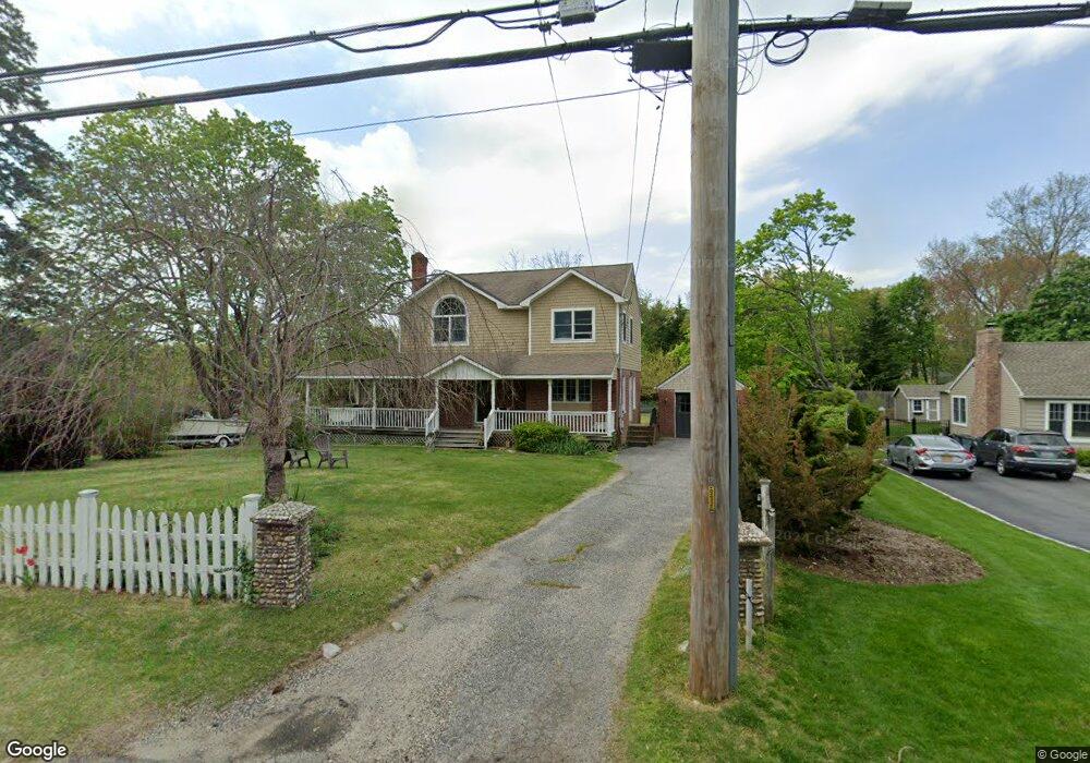
19 Clarke Dr East Northport, NY 11731
Estimated Value: $714,061 - $786,000
--
Bed
--
Bath
--
Sq Ft
0.5
Acres
About This Home
This home is located at 19 Clarke Dr, East Northport, NY 11731 and is currently estimated at $745,765. 19 Clarke Dr is a home located in Suffolk County with nearby schools including Northport Senior High School, The School House, and Trinity Regional School-East Northport Campus.
Ownership History
Date
Name
Owned For
Owner Type
Purchase Details
Closed on
Aug 26, 1998
Sold by
Labat Pierre D and Labat Adele
Bought by
Kranenberg Stephen G and Kranenberg Joan M
Current Estimated Value
Home Financials for this Owner
Home Financials are based on the most recent Mortgage that was taken out on this home.
Original Mortgage
$160,000
Outstanding Balance
$34,178
Interest Rate
6.9%
Estimated Equity
$711,587
Create a Home Valuation Report for This Property
The Home Valuation Report is an in-depth analysis detailing your home's value as well as a comparison with similar homes in the area
Home Values in the Area
Average Home Value in this Area
Purchase History
| Date | Buyer | Sale Price | Title Company |
|---|---|---|---|
| Kranenberg Stephen G | $225,000 | First American Title Ins Co |
Source: Public Records
Mortgage History
| Date | Status | Borrower | Loan Amount |
|---|---|---|---|
| Open | Kranenberg Stephen G | $160,000 |
Source: Public Records
Tax History Compared to Growth
Tax History
| Year | Tax Paid | Tax Assessment Tax Assessment Total Assessment is a certain percentage of the fair market value that is determined by local assessors to be the total taxable value of land and additions on the property. | Land | Improvement |
|---|---|---|---|---|
| 2024 | $10,297 | $3,200 | $225 | $2,975 |
| 2023 | $5,148 | $3,200 | $225 | $2,975 |
| 2022 | $9,680 | $3,200 | $225 | $2,975 |
| 2021 | $9,376 | $3,200 | $225 | $2,975 |
| 2020 | $9,225 | $3,200 | $225 | $2,975 |
| 2019 | $18,450 | $0 | $0 | $0 |
| 2018 | $8,655 | $3,200 | $225 | $2,975 |
| 2017 | $8,655 | $3,200 | $225 | $2,975 |
| 2016 | $9,069 | $3,400 | $225 | $3,175 |
| 2015 | -- | $3,400 | $225 | $3,175 |
| 2014 | -- | $3,400 | $225 | $3,175 |
Source: Public Records
Map
Nearby Homes
- 167 Vernon Valley Rd
- 44 Grant St
- 18 Norton Dr
- 27 Brittany Ct
- 267 Laurel Rd
- 15 Crest Dr
- 96 Bellecrest Ave
- 33 Alsace Place
- 292 Laurel Rd
- 96 Soundview Ave
- 62 Forest Dr
- 65 Circle Dr
- 110 Bellecrest Ave
- 301 Laurel Rd
- 54A Upland Dr
- 22 Middleville Rd
- 119 Catherine St
- 30 Middleville Rd
- 72 Upland Dr
- 66 Upland Dr