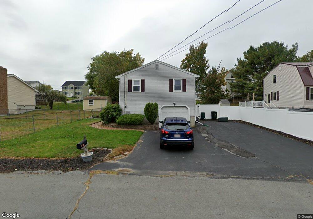
19 Derry Rd Methuen, MA 01844
The East End NeighborhoodEstimated Value: $545,292 - $612,000
3
Beds
2
Baths
1,382
Sq Ft
$416/Sq Ft
Est. Value
About This Home
This home is located at 19 Derry Rd, Methuen, MA 01844 and is currently estimated at $575,323, approximately $416 per square foot. 19 Derry Rd is a home located in Essex County with nearby schools including Timony Grammar School, Methuen High School, and Community Day Charter Public School - Gateway.
Ownership History
Date
Name
Owned For
Owner Type
Purchase Details
Closed on
May 29, 2018
Sold by
Obrien Daniel M and Obrien Mindy
Bought by
Obrien Mindy C
Current Estimated Value
Purchase Details
Closed on
May 24, 2007
Sold by
Shevlin Carrie Ann and Shevlin Keith Brian
Bought by
Obrien Daniel M and Obrien Mindy
Home Financials for this Owner
Home Financials are based on the most recent Mortgage that was taken out on this home.
Original Mortgage
$285,000
Interest Rate
6.27%
Mortgage Type
Purchase Money Mortgage
Purchase Details
Closed on
Nov 30, 1994
Sold by
Landry Mario
Bought by
Shevlin Keith
Create a Home Valuation Report for This Property
The Home Valuation Report is an in-depth analysis detailing your home's value as well as a comparison with similar homes in the area
Home Values in the Area
Average Home Value in this Area
Purchase History
| Date | Buyer | Sale Price | Title Company |
|---|---|---|---|
| Obrien Mindy C | -- | -- | |
| Obrien Mindy C | -- | -- | |
| Obrien Mindy C | -- | -- | |
| Obrien Daniel M | $300,000 | -- | |
| Obrien Daniel M | $300,000 | -- | |
| Shevlin Keith | $90,000 | -- | |
| Shevlin Keith | $90,000 | -- |
Source: Public Records
Mortgage History
| Date | Status | Borrower | Loan Amount |
|---|---|---|---|
| Previous Owner | Obrien Daniel M | $285,000 | |
| Previous Owner | Shevlin Keith | $113,000 | |
| Previous Owner | Shevlin Keith | $86,400 |
Source: Public Records
Tax History
| Year | Tax Paid | Tax Assessment Tax Assessment Total Assessment is a certain percentage of the fair market value that is determined by local assessors to be the total taxable value of land and additions on the property. | Land | Improvement |
|---|---|---|---|---|
| 2025 | $4,997 | $472,300 | $192,700 | $279,600 |
| 2024 | $5,048 | $464,800 | $175,800 | $289,000 |
| 2023 | $4,755 | $406,400 | $156,200 | $250,200 |
| 2022 | $4,573 | $350,400 | $130,200 | $220,200 |
| 2021 | $4,340 | $329,000 | $123,700 | $205,300 |
| 2020 | $4,301 | $320,000 | $123,700 | $196,300 |
| 2019 | $4,038 | $284,600 | $110,700 | $173,900 |
| 2018 | $3,890 | $272,600 | $110,700 | $161,900 |
| 2017 | $3,731 | $254,700 | $110,700 | $144,000 |
| 2016 | $3,587 | $242,200 | $104,200 | $138,000 |
| 2015 | $3,492 | $239,200 | $104,200 | $135,000 |
Source: Public Records
Map
Nearby Homes
- 30 Anderson Dr
- 51 Ford St Unit A
- 5 Pilgrim Cir Unit C
- 68 Ashford St
- 396 Oak St
- 10 Fenwick Cir
- 16 Christopher Dr Unit 38
- 45 Christopher Dr Unit 106
- 128 Pleasant Valley St
- 201 Aberdeen Rd
- 1 Riverview Blvd Unit 8-203
- 1 Riverview Blvd Unit 1:209
- 1 Riverview Blvd Unit 4-203
- 17 Ferry Rd
- 7 Erhardt Terrace
- 27 Russell Farm Dr
- 18 Erhardt Terrace
- 65 Arthur St
- 6 Ferry Rd
- 32 Josephine Ave
Your Personal Tour Guide
Ask me questions while you tour the home.