
Seller's Agent in 2026
Jason Burkholder
Hometown Property Sales
(717) 371-0557
28 in this area
163 Total Sales


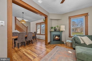

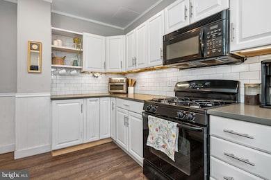
Welcome home to Lititz Life! The welcoming front porch of this home leads you right into the traditional semi detached floor plan, where well defined rooms with warm wood floors flow together nicely for easy entertaining! The right sized backyard is the perfect getaway, and the upstairs bedrooms offer plenty of space and privacy. With loads of storage, and modern updates that were made but kept the classic charm, you're going to love how this home looks just as good in person as it does in the pictures! This great home is just a few short blocks from all Downtown Lititz and small town USA life has to offer, so call to see this one in person today!
Last Agent to Sell the Property
(717) 207-8093 jeff@hometownprops.com Hometown Property Sales Brokerage Phone: 7172078093 License #AB066232 Listed on: 12/12/2025
Last Buyer's Agent
(717) 560-9100 dishler@homesale.com Berkshire Hathaway HomeServices Homesale Realty License #RS320701
| Date | Type | Sale Price | Title Company |
|---|---|---|---|
| Deed | $315,000 | Real Abstract | |
| Deed | $164,700 | None Available | |
| Deed | $148,500 | None Available |
| Date | Status | Loan Amount | Loan Type |
|---|---|---|---|
| Open | $190,000 | New Conventional | |
| Previous Owner | $168,061 | Purchase Money Mortgage | |
| Previous Owner | $148,000 | Fannie Mae Freddie Mac |
| Date | Event | Price | List to Sale | Price per Sq Ft |
|---|---|---|---|---|
| 01/29/2026 01/29/26 | Sold | $315,000 | +12.9% | $186 / Sq Ft |
| 12/16/2025 12/16/25 | Pending | -- | -- | -- |
| 12/12/2025 12/12/25 | For Sale | $279,000 | -- | $165 / Sq Ft |
| Year | Tax Paid | Tax Assessment Tax Assessment Total Assessment is a certain percentage of the fair market value that is determined by local assessors to be the total taxable value of land and additions on the property. | Land | Improvement |
|---|---|---|---|---|
| 2025 | $2,921 | $129,100 | $35,800 | $93,300 |
| 2024 | $2,921 | $129,100 | $35,800 | $93,300 |
| 2023 | $2,909 | $129,100 | $35,800 | $93,300 |
| 2022 | $2,748 | $129,100 | $35,800 | $93,300 |
| 2021 | $2,748 | $129,100 | $35,800 | $93,300 |
| 2020 | $2,748 | $129,100 | $35,800 | $93,300 |
| 2019 | $2,748 | $129,100 | $35,800 | $93,300 |
| 2018 | $1,999 | $129,100 | $35,800 | $93,300 |
| 2017 | $2,616 | $96,600 | $30,200 | $66,400 |
| 2016 | $2,616 | $96,600 | $30,200 | $66,400 |
| 2015 | $612 | $96,600 | $30,200 | $66,400 |
| 2014 | $1,790 | $96,600 | $30,200 | $66,400 |
Seller's Agent in 2026
Jason Burkholder
Hometown Property Sales
(717) 371-0557
28 in this area
163 Total Sales
Buyer's Agent in 2026
David Ishler
Berkshire Hathaway HomeServices Homesale Realty
(717) 350-3079
9 in this area
172 Total Sales
Source: Bright MLS
MLS Number: PALA2080574
APN: 370-08567-0-0000
Disclaimer: Certain information contained herein is derived from information provided by parties other than Homes.com. All information provided is deemed reliable, but is not guaranteed to be accurate and should be independently verified.
![]() The data relating to real estate for sale on this website appears in part through the BRIGHT Internet Data Exchange program, a voluntary cooperative exchange of property listing data between licensed real estate brokerage firms, and is provided by BRIGHT through a licensing agreement.
The data relating to real estate for sale on this website appears in part through the BRIGHT Internet Data Exchange program, a voluntary cooperative exchange of property listing data between licensed real estate brokerage firms, and is provided by BRIGHT through a licensing agreement.
Listing information is from various brokers who participate in the Bright MLS IDX program and not all listings may be visible on the site.
The property information being provided on or through the website is for the personal, non-commercial use of consumers and such information may not be used for any purpose other than to identify prospective properties consumers may be interested in purchasing.
Some properties which appear for sale on the website may no longer be available because they are for instance, under contract, sold or are no longer being offered for sale.
Property information displayed is deemed reliable but is not guaranteed.
Copyright 2026 Bright MLS, Inc.
Ask me questions while you tour the home.