Estimated Value: $377,140 - $403,000
3
Beds
1
Bath
1,067
Sq Ft
$362/Sq Ft
Est. Value
About This Home
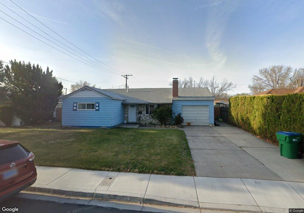
This home is located at 19 E M St, Sparks, NV 89431 and is currently estimated at $386,285, approximately $362 per square foot. 19 E M St is a home located in Washoe County with nearby schools including Greenbrae Elementary School, George L Dilworth Middle School, and Sparks High School.
Ownership History
Date
Name
Owned For
Owner Type
Purchase Details
Closed on
Jun 28, 2001
Sold by
Thomas Lonnie F and Thomas Kathleen Nina
Bought by
Noel Anne M
Current Estimated Value
Home Financials for this Owner
Home Financials are based on the most recent Mortgage that was taken out on this home.
Original Mortgage
$123,190
Outstanding Balance
$45,818
Interest Rate
7.14%
Estimated Equity
$340,467
Create a Home Valuation Report for This Property
The Home Valuation Report is an in-depth analysis detailing your home's value as well as a comparison with similar homes in the area
Home Values in the Area
Average Home Value in this Area
Purchase History
| Date | Buyer | Sale Price | Title Company |
|---|---|---|---|
| Noel Anne M | $127,000 | First Centennial Title Co |
Source: Public Records
Mortgage History
| Date | Status | Borrower | Loan Amount |
|---|---|---|---|
| Open | Noel Anne M | $123,190 |
Source: Public Records
Tax History
| Year | Tax Paid | Tax Assessment Tax Assessment Total Assessment is a certain percentage of the fair market value that is determined by local assessors to be the total taxable value of land and additions on the property. | Land | Improvement |
|---|---|---|---|---|
| 2026 | $523 | $50,415 | $34,090 | $16,325 |
| 2025 | $682 | $49,771 | $33,565 | $16,206 |
| 2024 | $682 | $46,041 | $30,065 | $15,976 |
| 2023 | $663 | $46,112 | $31,325 | $14,787 |
| 2022 | $644 | $38,236 | $26,180 | $12,056 |
| 2021 | $626 | $29,696 | $17,955 | $11,741 |
| 2020 | $606 | $28,463 | $16,940 | $11,523 |
| 2019 | $589 | $26,978 | $15,890 | $11,088 |
| 2018 | $571 | $22,358 | $11,725 | $10,633 |
| 2017 | $554 | $20,876 | $10,395 | $10,481 |
| 2016 | $548 | $19,812 | $9,345 | $10,467 |
| 2015 | $549 | $18,085 | $7,700 | $10,385 |
| 2014 | $533 | $16,267 | $6,440 | $9,827 |
| 2013 | -- | $13,953 | $4,270 | $9,683 |
Source: Public Records
Map
Nearby Homes
- 31 E L St
- 14 E Greenbrae Dr
- 8 E O St
- 11 E J St
- 370 O'Brien Way
- 115 P St
- 314 M St
- 480 E Mclean Way
- 28 Arndell Way
- 1940 4th St Unit 20
- 1940 4th St Unit 51
- 1940 4th St Unit 46
- 343 Richards Way
- 1945 4th St Unit 22
- 1945 4th St Unit 51
- 91 E York Way
- 136 York Way Unit 1
- 959 Mesa Ridge Dr Unit 2
- 355 York Way
- 1777 Howard Ct
Your Personal Tour Guide
Ask me questions while you tour the home.