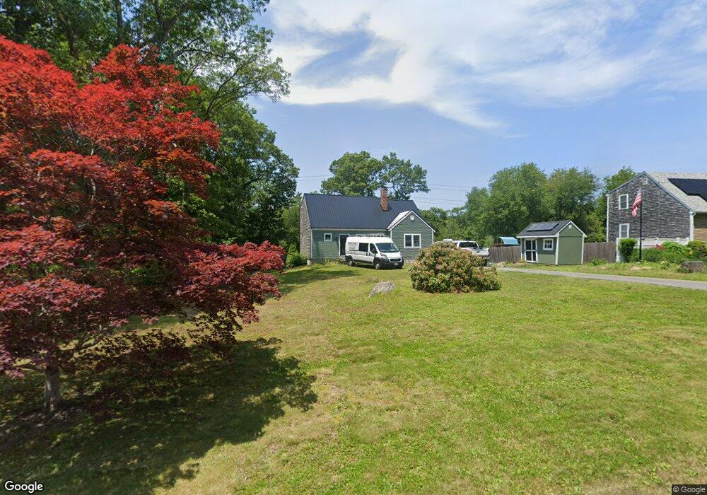
19 Elliot Ln Plymouth, MA 02360
Estimated Value: $562,000 - $708,000
3
Beds
2
Baths
1,521
Sq Ft
$413/Sq Ft
Est. Value
About This Home
This home is located at 19 Elliot Ln, Plymouth, MA 02360 and is currently estimated at $627,581, approximately $412 per square foot. 19 Elliot Ln is a home located in Plymouth County with nearby schools including Nathaniel Morton Elementary School, Plymouth Community Intermediate, and Plymouth North High School.
Ownership History
Date
Name
Owned For
Owner Type
Purchase Details
Closed on
Jul 3, 2008
Sold by
Home Loan Svcs Inc and Deutsche Bank Natl T C
Bought by
Marquis James J
Current Estimated Value
Home Financials for this Owner
Home Financials are based on the most recent Mortgage that was taken out on this home.
Original Mortgage
$225,900
Interest Rate
6.01%
Mortgage Type
Purchase Money Mortgage
Purchase Details
Closed on
Oct 30, 2007
Sold by
Elliott Nancy A and Foye Nancy A
Bought by
Deutsche Bank Natl T C
Purchase Details
Closed on
Mar 23, 2007
Sold by
Elliott David M and Elliott Nancy A
Bought by
Elliott Nancy A
Purchase Details
Closed on
Apr 3, 1990
Sold by
Hingham Inst For Svgs
Bought by
Elliott David M
Create a Home Valuation Report for This Property
The Home Valuation Report is an in-depth analysis detailing your home's value as well as a comparison with similar homes in the area
Home Values in the Area
Average Home Value in this Area
Purchase History
| Date | Buyer | Sale Price | Title Company |
|---|---|---|---|
| Marquis James J | $251,000 | -- | |
| Deutsche Bank Natl T C | $215,661 | -- | |
| Elliott Nancy A | -- | -- | |
| Elliott David M | $120,683 | -- | |
| Elliott David M | $120,683 | -- |
Source: Public Records
Mortgage History
| Date | Status | Borrower | Loan Amount |
|---|---|---|---|
| Open | Elliott David M | $220,000 | |
| Closed | Elliott David M | $225,900 |
Source: Public Records
Tax History Compared to Growth
Tax History
| Year | Tax Paid | Tax Assessment Tax Assessment Total Assessment is a certain percentage of the fair market value that is determined by local assessors to be the total taxable value of land and additions on the property. | Land | Improvement |
|---|---|---|---|---|
| 2025 | $5,557 | $437,900 | $216,500 | $221,400 |
| 2024 | $5,462 | $424,400 | $197,500 | $226,900 |
| 2023 | $5,315 | $387,700 | $177,500 | $210,200 |
| 2022 | $5,090 | $329,900 | $167,300 | $162,600 |
| 2021 | $4,947 | $306,100 | $167,300 | $138,800 |
| 2020 | $4,735 | $289,600 | $152,300 | $137,300 |
| 2019 | $4,643 | $280,700 | $142,300 | $138,400 |
| 2018 | $4,452 | $270,500 | $132,300 | $138,200 |
| 2017 | $4,218 | $254,400 | $132,300 | $122,100 |
| 2016 | $3,996 | $245,600 | $122,300 | $123,300 |
| 2015 | $3,754 | $241,600 | $117,300 | $124,300 |
| 2014 | $3,596 | $237,700 | $117,300 | $120,400 |
Source: Public Records
Map
Nearby Homes
- 65 Old Field Rd Unit 65
- 84 Old Field Rd Unit 84
- 15 Cedar Rd
- 583 State Rd
- 814 Rocky Hill Rd
- 9 Sunflower Way
- 4 Lady Bug Ln
- 3 Lady Bug Ln
- 4 Priscilla Beach Rd
- 88 Beach St
- 80 Kestrel Heights Unit 40
- 43 Kestrel Heights Unit 68
- 78 Kestrel Heights Unit 39
- 43 Kestrel Heights
- 78 Kestrel Heights
- 80 Kestrel Heights
- 39 Kestrel Heights Unit 70
- 33 Kestrel Heights
- 35 Kestrel Heights Unit 72
- 27 Kestrel Heights Unit 76