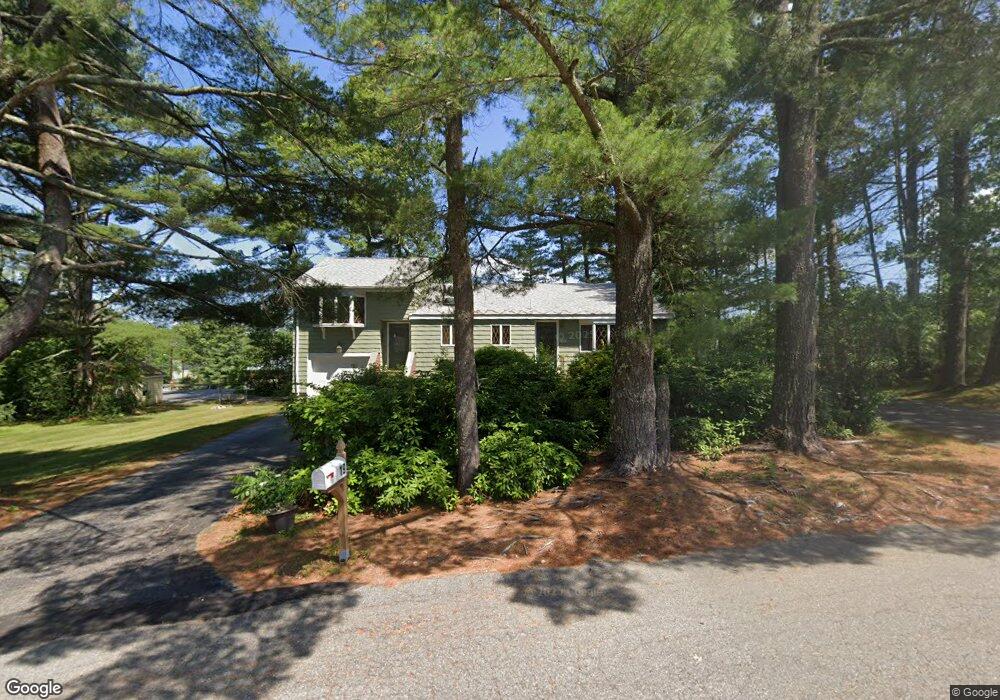
19 Forrest Rd Walpole, MA 02081
Estimated Value: $592,000 - $669,000
3
Beds
2
Baths
1,392
Sq Ft
$452/Sq Ft
Est. Value
About This Home
This home is located at 19 Forrest Rd, Walpole, MA 02081 and is currently estimated at $628,676, approximately $451 per square foot. 19 Forrest Rd is a home located in Norfolk County with nearby schools including Elm Street School, Eleanor N. Johnson Middle School, and Walpole High School.
Create a Home Valuation Report for This Property
The Home Valuation Report is an in-depth analysis detailing your home's value as well as a comparison with similar homes in the area
Home Values in the Area
Average Home Value in this Area
Tax History
| Year | Tax Paid | Tax Assessment Tax Assessment Total Assessment is a certain percentage of the fair market value that is determined by local assessors to be the total taxable value of land and additions on the property. | Land | Improvement |
|---|---|---|---|---|
| 2025 | $6,933 | $540,400 | $278,800 | $261,600 |
| 2024 | $6,688 | $505,900 | $268,000 | $237,900 |
| 2023 | $6,446 | $464,100 | $233,100 | $231,000 |
| 2022 | $6,082 | $420,600 | $215,900 | $204,700 |
| 2021 | $5,845 | $393,900 | $203,600 | $190,300 |
| 2020 | $5,618 | $374,800 | $182,000 | $192,800 |
| 2019 | $5,416 | $358,700 | $175,100 | $183,600 |
| 2018 | $5,033 | $329,600 | $159,500 | $170,100 |
| 2017 | $4,866 | $317,400 | $153,300 | $164,100 |
| 2016 | $4,863 | $312,500 | $156,100 | $156,400 |
| 2015 | $4,418 | $281,400 | $132,200 | $149,200 |
| 2014 | $4,186 | $265,600 | $132,200 | $133,400 |
Source: Public Records
Map
Nearby Homes
- 31 Sandtrap Cir Unit 500
- 25 Sandtrap Cir Unit 8
- 29 Sandtrap Cir Unit 6
- 27 Sandtrap Cir Unit 7
- 21 Sandtrap Cir Unit 10
- 23 Sandtrap Cir Unit 9
- 27 Sandtrip Cir Unit 7
- 10 Sandtrap Cir Unit 2
- 13 Sandtrap Cir Unit 14
- 11 Sandtrap Cir Unit 15
- 12 Weathervane Dr Unit 21
- 20 Sandtrap Cir Unit 4
- 19 Sandtrap Cir Unit 11
- 14 Weathervane Dr Unit 22
- 18 Sandtrap Cir Unit 3
- 17 Sandtrap Cir Unit 12
- 15 Sandtrap Cir Unit 13
- 3 Weathervane Dr Unit 1
- 10 Weathervane Dr Unit 20
- 195 Lincoln Rd
- 480 West St
- 22 Forrest Rd
- 10 Forrest Rd
- 530 West St
- 252 Norfolk St
- 14 Tiger Terrace Unit 29
- 475 West St
- 31 Sandtrap Cir Unit 5
- 534 West St
- 531 West St
- 35 Merchants Dr
- 35 Merchants Dr Unit C
- 220 Norfolk St
- 231 Norfolk St
- 557 West St
- 5 Merchants Dr
- 6 Merchants Drive Lot 6
- 30 Merchants Dr
- 20 Merchants Dr
- 36 Renmar Ave
Your Personal Tour Guide
Ask me questions while you tour the home.