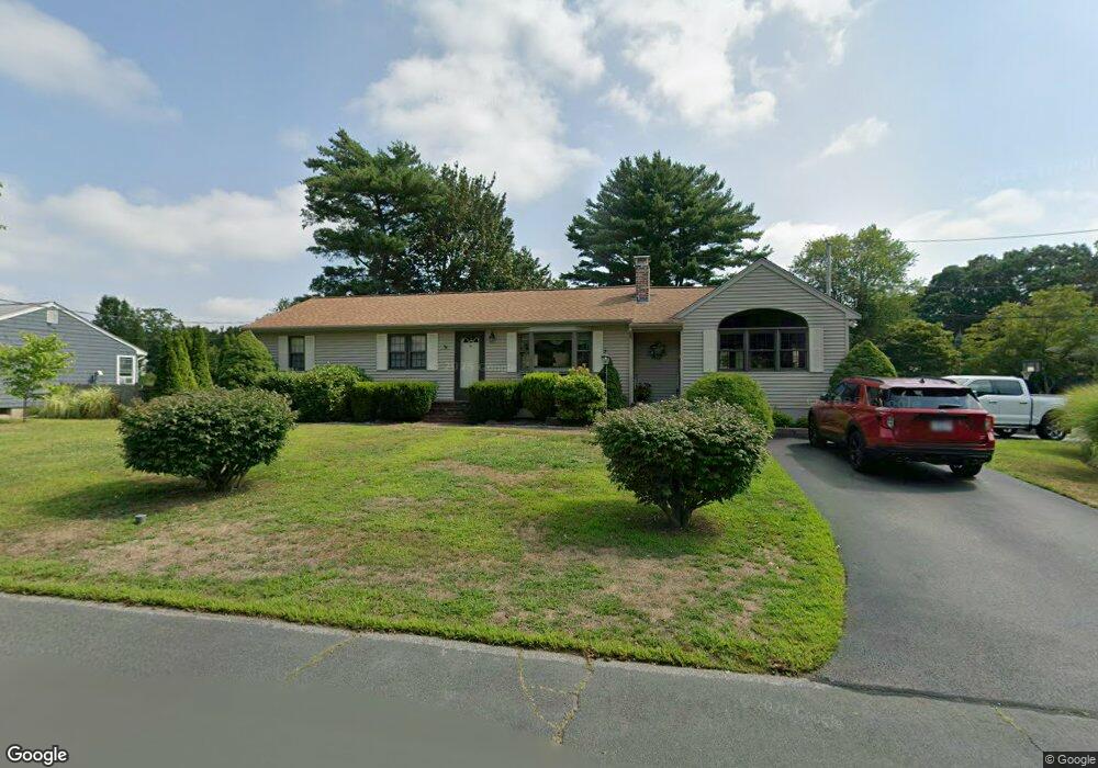
19 George St North Attleboro, MA 02760
North Attleboro NeighborhoodEstimated Value: $612,706 - $637,000
3
Beds
2
Baths
1,545
Sq Ft
$405/Sq Ft
Est. Value
About This Home
This home is located at 19 George St, North Attleboro, MA 02760 and is currently estimated at $625,177, approximately $404 per square foot. 19 George St is a home located in Bristol County with nearby schools including North Attleboro High School, Cadence Academy Preschool - North Attleborough, and Bishop Feehan High School.
Ownership History
Date
Name
Owned For
Owner Type
Purchase Details
Closed on
May 20, 2024
Sold by
Mckeon Robert J
Bought by
Rj Mckeon Rt and Mckeon
Current Estimated Value
Purchase Details
Closed on
Jan 1, 1975
Bought by
Mckeon Robert J and Mckeon Lorna M
Create a Home Valuation Report for This Property
The Home Valuation Report is an in-depth analysis detailing your home's value as well as a comparison with similar homes in the area
Home Values in the Area
Average Home Value in this Area
Purchase History
| Date | Buyer | Sale Price | Title Company |
|---|---|---|---|
| Rj Mckeon Rt | -- | None Available | |
| Rj Mckeon Rt | -- | None Available | |
| Mckeon Robert J | -- | -- |
Source: Public Records
Mortgage History
| Date | Status | Borrower | Loan Amount |
|---|---|---|---|
| Previous Owner | Mckeon Robert J | $115,000 |
Source: Public Records
Tax History Compared to Growth
Tax History
| Year | Tax Paid | Tax Assessment Tax Assessment Total Assessment is a certain percentage of the fair market value that is determined by local assessors to be the total taxable value of land and additions on the property. | Land | Improvement |
|---|---|---|---|---|
| 2025 | $6,173 | $523,600 | $146,000 | $377,600 |
| 2024 | $5,835 | $505,600 | $146,000 | $359,600 |
| 2023 | $5,626 | $439,900 | $146,000 | $293,900 |
| 2022 | $5,137 | $368,800 | $146,000 | $222,800 |
| 2021 | $5,354 | $375,200 | $146,000 | $229,200 |
| 2020 | $5,023 | $350,000 | $146,000 | $204,000 |
| 2019 | $4,832 | $339,300 | $132,700 | $206,600 |
| 2018 | $4,234 | $317,400 | $132,700 | $184,700 |
| 2017 | $4,076 | $308,300 | $132,700 | $175,600 |
| 2016 | $3,930 | $297,300 | $147,400 | $149,900 |
| 2015 | $3,737 | $284,400 | $147,400 | $137,000 |
| 2014 | $3,531 | $266,700 | $129,400 | $137,300 |
Source: Public Records
Map
Nearby Homes
- 16 Raymond Hall Dr
- 116 George St
- 10 Sleepy Hollow Cir
- 11 Landry Ave
- 15 Old Wood Rd
- 57 Vine St
- 28 Messenger St
- 33 Dublin Way
- Lot 5 Jeffrey Dr
- 2 George St Unit C
- 9 Sunnyside Dr Unit 9
- 166 E Bacon St Unit 4
- Lot 2 Jeffrey Dr
- 115 Westfield Dr
- 24 Red Coat Ln
- 17 Peters Way
- 1730 West St
- 36 Cranberry Rd
- 12 Houde St
- 2 Woodridge St Unit 2