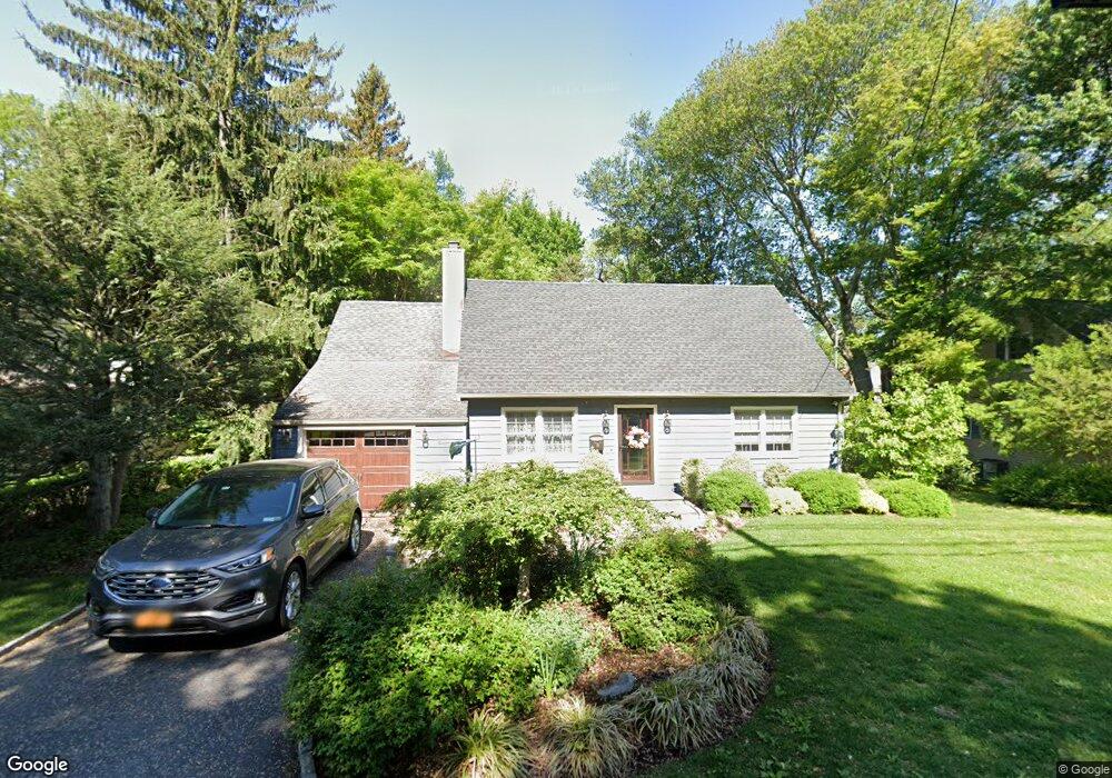
19 Highland Ave Tarrytown, NY 10591
Estimated Value: $887,000 - $1,101,223
4
Beds
2
Baths
2,061
Sq Ft
$486/Sq Ft
Est. Value
About This Home
This home is located at 19 Highland Ave, Tarrytown, NY 10591 and is currently estimated at $1,001,806, approximately $486 per square foot. 19 Highland Ave is a home located in Westchester County with nearby schools including Washington Irving Interm School, John Paulding School, and W L Morse School.
Ownership History
Date
Name
Owned For
Owner Type
Purchase Details
Closed on
Apr 27, 2021
Sold by
Aristy Mery A and Lazala Edwin
Bought by
Aristy Mery A
Current Estimated Value
Purchase Details
Closed on
Sep 26, 2014
Sold by
Townsend Tulloch M
Bought by
Townsend Tulloch M and Caramagna Tina
Purchase Details
Closed on
Oct 27, 2004
Sold by
Dolan Catherine E
Bought by
Townsend Tulloch M
Home Financials for this Owner
Home Financials are based on the most recent Mortgage that was taken out on this home.
Original Mortgage
$333,700
Interest Rate
4.62%
Mortgage Type
Purchase Money Mortgage
Create a Home Valuation Report for This Property
The Home Valuation Report is an in-depth analysis detailing your home's value as well as a comparison with similar homes in the area
Home Values in the Area
Average Home Value in this Area
Purchase History
| Date | Buyer | Sale Price | Title Company |
|---|---|---|---|
| Aristy Mery A | -- | None Listed On Document | |
| Townsend Tulloch M | -- | Fidelity Natl Title Ins Co | |
| Townsend Tulloch M | $531,000 | -- |
Source: Public Records
Mortgage History
| Date | Status | Borrower | Loan Amount |
|---|---|---|---|
| Previous Owner | Townsend Tulloch M | $333,700 |
Source: Public Records
Tax History Compared to Growth
Tax History
| Year | Tax Paid | Tax Assessment Tax Assessment Total Assessment is a certain percentage of the fair market value that is determined by local assessors to be the total taxable value of land and additions on the property. | Land | Improvement |
|---|---|---|---|---|
| 2024 | $27,221 | $886,900 | $282,300 | $604,600 |
| 2023 | $24,712 | $885,200 | $249,800 | $635,400 |
| 2022 | $23,749 | $777,200 | $249,800 | $527,400 |
| 2021 | $20,555 | $705,900 | $249,800 | $456,100 |
| 2020 | $20,419 | $592,700 | $249,800 | $342,900 |
| 2019 | $19,768 | $592,700 | $249,800 | $342,900 |
| 2018 | $23,350 | $582,100 | $249,800 | $332,300 |
| 2017 | $2,416 | $555,400 | $249,800 | $305,600 |
| 2016 | $393,946 | $534,000 | $249,800 | $284,200 |
| 2015 | -- | $17,100 | $2,300 | $14,800 |
| 2014 | -- | $17,100 | $2,300 | $14,800 |
| 2013 | $12,339 | $17,100 | $2,300 | $14,800 |
Source: Public Records
Map
Nearby Homes
- 94 Barnes Rd
- 43 Putnam Ave
- 14 Croton Ave
- 497 Martling Ave
- 18 N Broadway Unit 411
- 102 Legend Dr Unit 101
- 19 S Broadway Unit 4A
- 20 Benedict Ave
- 29 Woodland Ave
- 29 Dixon St
- 154 Martling Ave Unit 5-J6
- 103 Carrollwood Dr
- 93 Carrollwood Dr Unit 93
- 57 Cobb Ln
- 410 Benedict Ave Unit 5E
- 412 Benedict Ave Unit 5H
- 12 Hendrick Ln Unit 43E
- 443 Benedict Ave
- 26 Bridge St
- 300 S Broadway Unit 1C