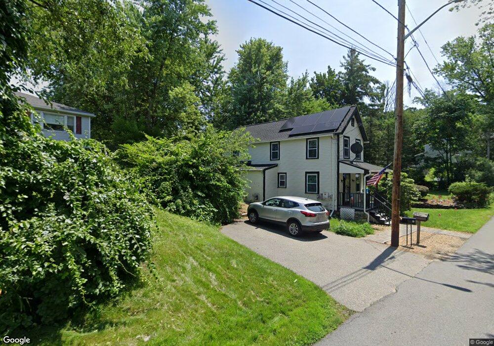
19 Hillside Ave Haverhill, MA 01835
Central Bradford NeighborhoodEstimated Value: $484,000 - $561,000
3
Beds
2
Baths
1,476
Sq Ft
$363/Sq Ft
Est. Value
About This Home
This home is located at 19 Hillside Ave, Haverhill, MA 01835 and is currently estimated at $536,503, approximately $363 per square foot. 19 Hillside Ave is a home located in Essex County with nearby schools including Greenleaf Academy, Bradford Elementary School, and Haverhill High School.
Ownership History
Date
Name
Owned For
Owner Type
Purchase Details
Closed on
May 30, 1997
Sold by
Riverbank Dev Corp
Bought by
Iversen Gary and Kimball-Iversen Judith
Current Estimated Value
Home Financials for this Owner
Home Financials are based on the most recent Mortgage that was taken out on this home.
Original Mortgage
$128,667
Interest Rate
8.09%
Mortgage Type
Purchase Money Mortgage
Purchase Details
Closed on
Aug 8, 1995
Sold by
D & D Rt
Bought by
Riverbank Dev Corp
Purchase Details
Closed on
Dec 22, 1994
Sold by
Gary Rt
Bought by
D & D Rt
Create a Home Valuation Report for This Property
The Home Valuation Report is an in-depth analysis detailing your home's value as well as a comparison with similar homes in the area
Home Values in the Area
Average Home Value in this Area
Purchase History
| Date | Buyer | Sale Price | Title Company |
|---|---|---|---|
| Iversen Gary | $135,450 | -- | |
| Riverbank Dev Corp | $35,000 | -- | |
| D & D Rt | $20,000 | -- |
Source: Public Records
Mortgage History
| Date | Status | Borrower | Loan Amount |
|---|---|---|---|
| Open | D & D Rt | $126,000 | |
| Closed | D & D Rt | $122,000 | |
| Closed | D & D Rt | $128,667 |
Source: Public Records
Tax History
| Year | Tax Paid | Tax Assessment Tax Assessment Total Assessment is a certain percentage of the fair market value that is determined by local assessors to be the total taxable value of land and additions on the property. | Land | Improvement |
|---|---|---|---|---|
| 2025 | $4,764 | $444,800 | $168,800 | $276,000 |
| 2024 | $4,546 | $427,300 | $160,300 | $267,000 |
| 2023 | $4,263 | $382,300 | $139,200 | $243,100 |
| 2022 | $4,102 | $322,500 | $126,600 | $195,900 |
| 2021 | $4,017 | $298,900 | $119,500 | $179,400 |
| 2020 | $3,997 | $293,900 | $119,500 | $174,400 |
| 2019 | $3,885 | $278,500 | $104,100 | $174,400 |
| 2018 | $3,728 | $261,400 | $98,500 | $162,900 |
| 2017 | $3,725 | $248,500 | $95,600 | $152,900 |
| 2016 | $3,636 | $236,700 | $87,200 | $149,500 |
| 2015 | $3,633 | $236,700 | $87,200 | $149,500 |
Source: Public Records
Map
Nearby Homes
- 18 Wainwright Ave
- 647 S Main St Unit B
- 31 Rainbow Dr
- 59 Riverdale Ave Unit 2
- 552 S Main St Unit 2
- 80/88 River St
- 41 Sherwood Dr
- 552 Washington St
- 2 Marion St
- 27 Vernon St
- 260 Willow Ave
- 219 River St
- 19 Observatory Ave
- 8 Ford St
- 10 Winchester St
- 399 S Main St
- 54 Observatory Ave
- 21 Conover Way
- 18 Greenleaf St
- 499 Chadwick Rd
- 18 Hillside Ave
- 14 Wainwright Ave
- 21 Hillside Ave
- 12 Hillside Ave
- 14 Hillside Ave
- 30 Wainwright Ave
- 19 Wainwright Ave
- 10 Wainwright Ave
- 22 Hillside Ave
- 15 Wainwright Ave
- 4 Hillside Ave
- 2 Hillside Ave
- 11 Wainwright Ave
- 11 Wainwright Ave Unit 11
- 11 Wainwright Ave Unit 16
- 4 Wainwright Ave Unit 4
- 4 Wainwright Ave Unit 2
- 712 S Main St
- 712 S Main St Unit 1
- 40 Wainwright Ave
Your Personal Tour Guide
Ask me questions while you tour the home.