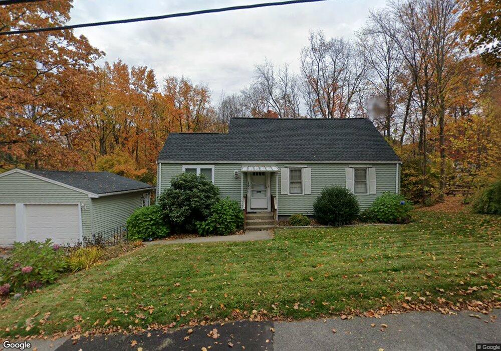
19 Kings Grant Rd Marlborough, MA 01752
Estimated Value: $448,000 - $503,000
2
Beds
1
Bath
930
Sq Ft
$523/Sq Ft
Est. Value
About This Home
This home is located at 19 Kings Grant Rd, Marlborough, MA 01752 and is currently estimated at $486,195, approximately $522 per square foot. 19 Kings Grant Rd is a home located in Middlesex County with nearby schools including Marlborough High School, New Covenant Christian School, and Glenhaven Academy - JRI School.
Ownership History
Date
Name
Owned For
Owner Type
Purchase Details
Closed on
Jul 26, 2013
Sold by
Leblanc Stacy M
Bought by
Diehl Scott
Current Estimated Value
Home Financials for this Owner
Home Financials are based on the most recent Mortgage that was taken out on this home.
Original Mortgage
$164,000
Outstanding Balance
$39,948
Interest Rate
3.97%
Mortgage Type
New Conventional
Estimated Equity
$446,247
Purchase Details
Closed on
Feb 22, 2012
Sold by
Est Myrick Thomas F and Lowe Gary
Bought by
Leblanc Stacy M
Create a Home Valuation Report for This Property
The Home Valuation Report is an in-depth analysis detailing your home's value as well as a comparison with similar homes in the area
Home Values in the Area
Average Home Value in this Area
Purchase History
| Date | Buyer | Sale Price | Title Company |
|---|---|---|---|
| Diehl Scott | $205,000 | -- | |
| Diehl Scott | $205,000 | -- | |
| Leblanc Stacy M | -- | -- |
Source: Public Records
Mortgage History
| Date | Status | Borrower | Loan Amount |
|---|---|---|---|
| Open | Diehl Scott | $164,000 | |
| Closed | Diehl Scott | $164,000 |
Source: Public Records
Tax History Compared to Growth
Tax History
| Year | Tax Paid | Tax Assessment Tax Assessment Total Assessment is a certain percentage of the fair market value that is determined by local assessors to be the total taxable value of land and additions on the property. | Land | Improvement |
|---|---|---|---|---|
| 2025 | $4,231 | $429,100 | $220,400 | $208,700 |
| 2024 | $4,079 | $398,300 | $200,300 | $198,000 |
| 2023 | $4,292 | $371,900 | $169,100 | $202,800 |
| 2022 | $4,168 | $317,700 | $161,100 | $156,600 |
| 2021 | $31,130 | $292,400 | $134,200 | $158,200 |
| 2020 | $8,840 | $279,100 | $127,800 | $151,300 |
| 2019 | $8,347 | $274,200 | $125,300 | $148,900 |
| 2018 | $30,820 | $248,500 | $99,900 | $148,600 |
| 2017 | $3,433 | $224,100 | $99,000 | $125,100 |
| 2016 | $3,326 | $216,800 | $99,000 | $117,800 |
| 2015 | $3,421 | $217,100 | $101,300 | $115,800 |
Source: Public Records
Map
Nearby Homes
- 11 Kings Grant Rd
- 24 Kings Grant Rd
- 64 Old Charter Rd
- 16 Kings Grant Rd
- 39 Kings Grant Rd
- 169 Clinton St
- 8 Kings Grant Rd
- 70 Old Charter Rd
- 40 Kings Grant Rd
- 49 Kings Grant Rd
- 48 Old Charter Rd
- 161 Clinton St
- 67 Old Charter Rd
- 48 Kings Grant Rd
- 59 Kings Grant Rd
- 162 Clinton St
- 82 Old Charter Rd
- 47 Old Charter Rd
- 77 Old Charter Rd
- 153 Clinton St