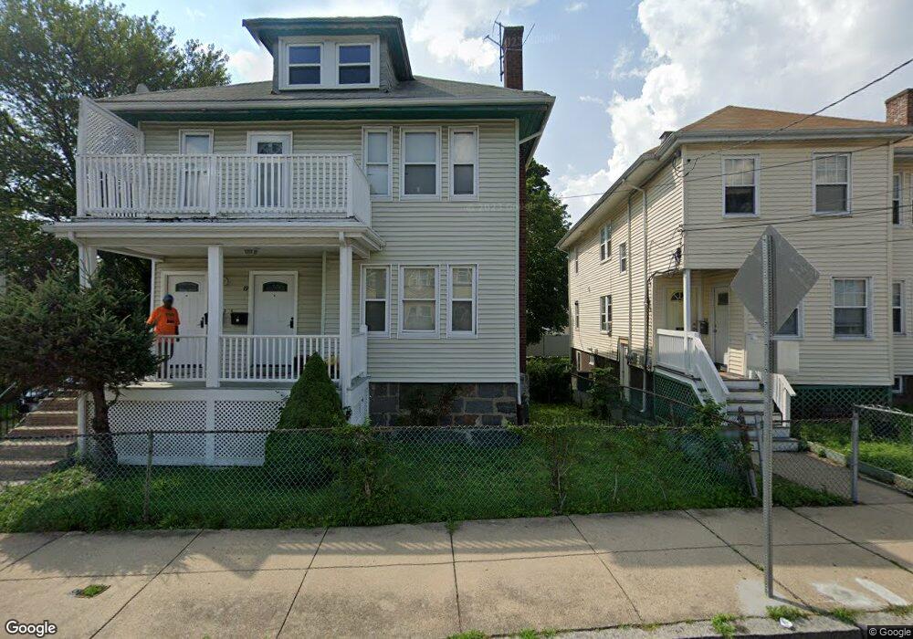
19 Lorna Rd Unit 21 Mattapan, MA 02126
Southern Mattapan NeighborhoodEstimated Value: $798,161 - $896,000
5
Beds
2
Baths
2,332
Sq Ft
$358/Sq Ft
Est. Value
About This Home
This home is located at 19 Lorna Rd Unit 21, Mattapan, MA 02126 and is currently estimated at $835,290, approximately $358 per square foot. 19 Lorna Rd Unit 21 is a home located in Suffolk County with nearby schools including KIPP Academy Boston Charter School and Berea Seventh-day Adventist Academy.
Ownership History
Date
Name
Owned For
Owner Type
Purchase Details
Closed on
Aug 18, 2011
Sold by
Riguad Montour Evans and Riguad Rene
Bought by
Rene Riguad and Rene Marie A
Current Estimated Value
Purchase Details
Closed on
Dec 20, 2006
Sold by
Melon Jacqueline and Melon Jeanot C
Bought by
Riguad Montour Evans and Riguad Rene
Home Financials for this Owner
Home Financials are based on the most recent Mortgage that was taken out on this home.
Original Mortgage
$360,000
Interest Rate
6.35%
Mortgage Type
Purchase Money Mortgage
Create a Home Valuation Report for This Property
The Home Valuation Report is an in-depth analysis detailing your home's value as well as a comparison with similar homes in the area
Home Values in the Area
Average Home Value in this Area
Purchase History
| Date | Buyer | Sale Price | Title Company |
|---|---|---|---|
| Rene Riguad | -- | -- | |
| Riguad Montour Evans | $450,000 | -- |
Source: Public Records
Mortgage History
| Date | Status | Borrower | Loan Amount |
|---|---|---|---|
| Previous Owner | Riguad Montour Evans | $360,000 |
Source: Public Records
Tax History Compared to Growth
Tax History
| Year | Tax Paid | Tax Assessment Tax Assessment Total Assessment is a certain percentage of the fair market value that is determined by local assessors to be the total taxable value of land and additions on the property. | Land | Improvement |
|---|---|---|---|---|
| 2025 | $7,918 | $683,800 | $192,600 | $491,200 |
| 2024 | $7,060 | $647,700 | $186,400 | $461,300 |
| 2023 | $6,440 | $599,600 | $172,600 | $427,000 |
| 2022 | $6,524 | $599,600 | $172,600 | $427,000 |
| 2021 | $6,036 | $565,700 | $162,800 | $402,900 |
| 2020 | $5,017 | $475,100 | $158,000 | $317,100 |
| 2019 | $4,468 | $423,900 | $119,400 | $304,500 |
| 2018 | $4,191 | $399,900 | $119,400 | $280,500 |
| 2017 | $4,071 | $384,400 | $119,400 | $265,000 |
| 2016 | $3,952 | $359,300 | $119,400 | $239,900 |
| 2015 | $3,430 | $283,200 | $93,900 | $189,300 |
| 2014 | $3,180 | $252,800 | $93,900 | $158,900 |
Source: Public Records
Map
Nearby Homes
- 15-17 W Selden St
- 808 Morton St Unit 3
- 139 Selden St
- 124 Selden St
- 32 Crowell St
- 18 Astoria St
- 30 Glenhill Rd
- 44 Evans St
- 68 Mascot St
- 147 Fairmount St
- 73 Stanton St
- 10 Sutton St
- 251 Norfolk St Unit A
- 5 Sutton St
- 5 Sutton St Unit 3B
- 23 Maryknoll St
- 38 Mascot St Unit 3
- 24 Marden Ave
- 67 Wildwood St
- 14-16 Jacob St
- 29 Lorna Rd
- 15 Lorna Rd Unit 17
- 15 Lorna Rd Unit 1
- 33 Lorna Rd
- 22 W Selden St
- 22 W Selden St Unit 1
- 18 W Selden St
- 9 Lorna Rd Unit 11
- 26 W Selden St
- 26 W Selden St Unit 2
- 26 W Selden St Unit 1
- 14 W Selden St Unit 16
- 14-16 W Selden St
- 14 W Selden St Unit 2
- 14 W Selden St Unit 1
- 30 W Selden St
- 2 Tiverton Rd
- 10 W Selden St
- 10 W Selden St Unit 1
- 34 W Selden St