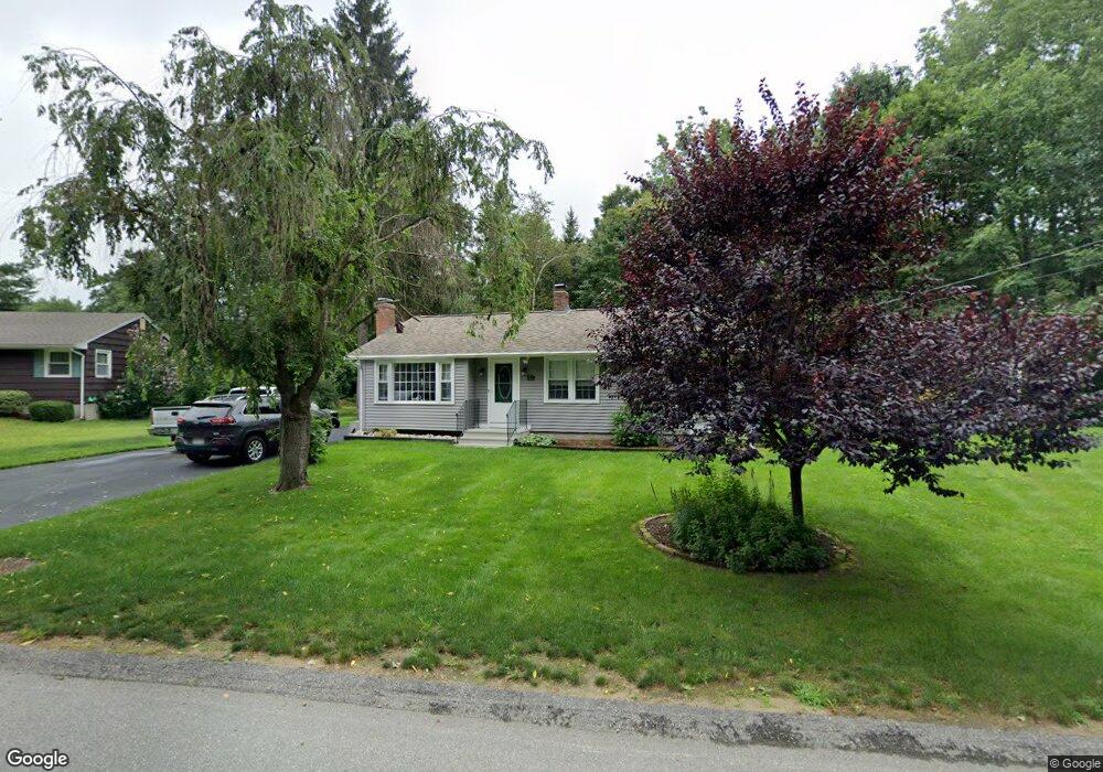
19 Miles Rd Rutland, MA 01543
Estimated Value: $418,000 - $616,000
3
Beds
3
Baths
2,132
Sq Ft
$247/Sq Ft
Est. Value
About This Home
This home is located at 19 Miles Rd, Rutland, MA 01543 and is currently estimated at $526,004, approximately $246 per square foot. 19 Miles Rd is a home located in Worcester County with nearby schools including Wachusett Regional High School.
Ownership History
Date
Name
Owned For
Owner Type
Purchase Details
Closed on
Jul 29, 1996
Sold by
Fnma
Bought by
Jrio Nancy
Current Estimated Value
Home Financials for this Owner
Home Financials are based on the most recent Mortgage that was taken out on this home.
Original Mortgage
$82,000
Interest Rate
8.37%
Mortgage Type
Purchase Money Mortgage
Purchase Details
Closed on
Sep 20, 1995
Sold by
Russo Edward R
Bought by
Federal National Mortgage Association
Create a Home Valuation Report for This Property
The Home Valuation Report is an in-depth analysis detailing your home's value as well as a comparison with similar homes in the area
Home Values in the Area
Average Home Value in this Area
Purchase History
| Date | Buyer | Sale Price | Title Company |
|---|---|---|---|
| Jrio Nancy | $94,000 | -- | |
| Federal National Mortgage Association | $85,500 | -- |
Source: Public Records
Mortgage History
| Date | Status | Borrower | Loan Amount |
|---|---|---|---|
| Open | Federal National Mortgage Association | $81,000 | |
| Closed | Federal National Mortgage Association | $82,000 |
Source: Public Records
Tax History Compared to Growth
Tax History
| Year | Tax Paid | Tax Assessment Tax Assessment Total Assessment is a certain percentage of the fair market value that is determined by local assessors to be the total taxable value of land and additions on the property. | Land | Improvement |
|---|---|---|---|---|
| 2025 | $4,938 | $346,800 | $80,000 | $266,800 |
| 2024 | $4,649 | $313,500 | $76,500 | $237,000 |
| 2023 | $4,239 | $309,000 | $72,200 | $236,800 |
| 2022 | $4,105 | $260,000 | $60,900 | $199,100 |
| 2021 | $3,831 | $229,400 | $60,900 | $168,500 |
| 2020 | $3,411 | $213,800 | $57,600 | $156,200 |
| 2019 | $3,685 | $206,000 | $54,900 | $151,100 |
| 2018 | $4,986 | $195,900 | $54,900 | $141,000 |
| 2017 | $3,020 | $190,100 | $54,900 | $135,200 |
| 2016 | $3,168 | $182,400 | $54,600 | $127,800 |
| 2015 | $2,960 | $167,700 | $54,600 | $113,100 |
| 2014 | $2,869 | $167,700 | $54,600 | $113,100 |
Source: Public Records
Map
Nearby Homes
- 5 Miles Rd
- 55 Pommogussett Rd
- 32 Pommogussett Rd Unit 1
- 10 Soucy Dr
- 16 Richards Ave
- 25 Watson Ln
- 28 Forest Hill Dr
- 40 Brunelle Dr
- 47 Woodside Ave
- 6 Lewis St
- 11 Lewis St
- 21 Lewis St
- 12 Lewis St
- 51 Woodside Ave
- 27 Lewis St
- 2 Forest Hill Dr
- 10 Fidelity Dr Unit 5
- 12 Fidelity Dr Unit 6
- 132 Fidelity Dr Unit 61
- Lot 24R Quail Run
- 17 Miles Rd
- Lot 1&3 Moulton Mill Rd
- 21 Miles Rd
- 16 Miles Rd
- 1 Moulton Mill Rd
- 3 Moulton Mill Rd
- 15 Miles Rd
- 14 Miles Rd
- 18 Miles Rd
- 12 Miles Rd
- 5 Moulton Mill Rd
- 9 Miles Rd
- 5 Depot Rd
- 8 Miles Rd
- 43 Pommogussett Rd
- 51 Pommogussett Rd
- 16 Moulton Mill Rd
- 0 Powell Trail Unit 71683062
- LOTS-1&3 Moulton Mill Rd
- 46 Pommogussett Rd