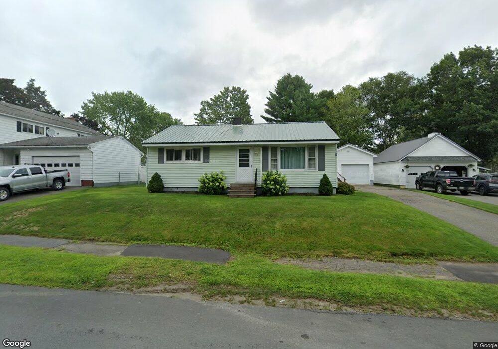
19 New York St Millinocket, ME 04462
Estimated Value: $152,113 - $197,000
--
Bed
--
Bath
--
Sq Ft
10,019
Sq Ft Lot
About This Home
This home is located at 19 New York St, Millinocket, ME 04462 and is currently estimated at $170,778. 19 New York St is a home with nearby schools including Granite Street School and Stearns Junior/Senior High School.
Ownership History
Date
Name
Owned For
Owner Type
Purchase Details
Closed on
May 28, 2015
Sold by
Boone Angela R
Bought by
Groh Alan H
Current Estimated Value
Purchase Details
Closed on
Mar 18, 2013
Sold by
Caron Yvonne M Est
Bought by
Boone Angela R
Home Financials for this Owner
Home Financials are based on the most recent Mortgage that was taken out on this home.
Original Mortgage
$33,250
Interest Rate
3.54%
Mortgage Type
Commercial
Create a Home Valuation Report for This Property
The Home Valuation Report is an in-depth analysis detailing your home's value as well as a comparison with similar homes in the area
Home Values in the Area
Average Home Value in this Area
Purchase History
| Date | Buyer | Sale Price | Title Company |
|---|---|---|---|
| Groh Alan H | -- | -- | |
| Boone Angela R | -- | -- |
Source: Public Records
Mortgage History
| Date | Status | Borrower | Loan Amount |
|---|---|---|---|
| Previous Owner | Boone Angela R | $33,250 |
Source: Public Records
Tax History Compared to Growth
Tax History
| Year | Tax Paid | Tax Assessment Tax Assessment Total Assessment is a certain percentage of the fair market value that is determined by local assessors to be the total taxable value of land and additions on the property. | Land | Improvement |
|---|---|---|---|---|
| 2025 | $2,077 | $90,300 | $12,000 | $78,300 |
| 2024 | $2,029 | $73,500 | $6,000 | $67,500 |
| 2023 | $1,692 | $60,000 | $6,000 | $54,000 |
| 2022 | $1,587 | $53,800 | $6,000 | $47,800 |
| 2021 | $1,489 | $45,800 | $6,000 | $39,800 |
| 2020 | $1,479 | $43,500 | $6,000 | $37,500 |
| 2019 | $1,436 | $43,500 | $6,000 | $37,500 |
| 2018 | $1,414 | $43,500 | $6,000 | $37,500 |
| 2017 | $1,405 | $43,500 | $6,000 | $37,500 |
| 2016 | $1,362 | $43,500 | $6,000 | $37,500 |
| 2015 | $1,290 | $43,500 | $6,000 | $37,500 |
| 2014 | $1,288 | $43,500 | $6,000 | $37,500 |
Source: Public Records
Map
Nearby Homes
- 54 Rhode Island Ave
- 92 Ohio St
- 86 Ohio St
- 47 New Jersey St
- 102 Connecticut Ave
- 45 Vermont St
- 125 Connecticut Ave
- 30 New Hampshire St
- 78 Massachusetts Ave
- 5 Grove St
- Lot # Fern St
- 73 Forest Ave
- 26 Pleasant St
- 13 Colony Place
- 6 Colony Place
- 22 Colony Place
- 899 Central St
- 23 Hillcrest Ave
- 6 & 6A Forest Ave
- 28 Eastland Ave
- 15 New York St
- 7 New York St
- 20 New York St
- 68 Rhode Island Ave
- 14 New York St
- 44 Rhode Island Ave
- 104 Ohio St
- 100 Ohio St
- 55 Rhode Island Ave
- 97 Cottage Rd
- 89 Cottage Rd
- 67 Rhode Island Ave
- 78 Rhode Island Ave
- 119 Cottage Rd
- 7 Michigan St
- 45 New York St
- 44 New York St
- 105 Ohio St
- 97 Ohio St
- 30 Rhode Island Ave