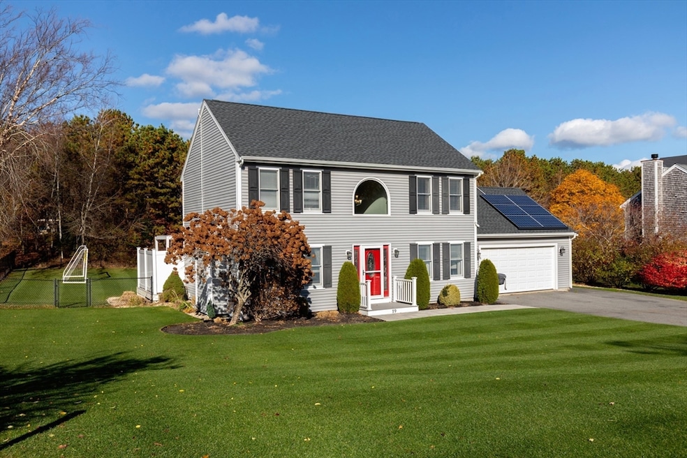
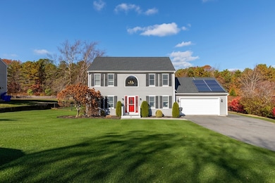
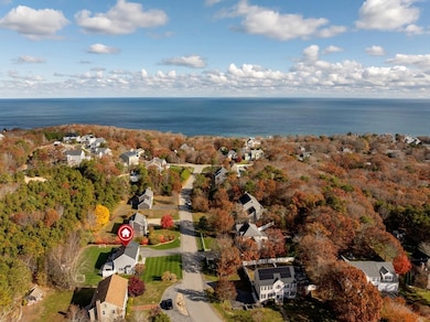
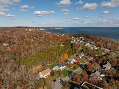
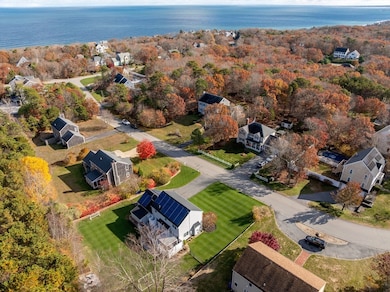
19 Oak Bluff Rd Sagamore Beach, MA 02562
Estimated payment $4,558/month
Highlights
- Hot Property
- Open Floorplan
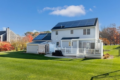
- Covered Deck
- Golf Course Community
- Colonial Architecture
- Bonus Room
About This Home
Walk to the Beach! Enjoy coastal living in the highly sought-after Sagamore Beach Highlands. This beautifully updated and very well-maintained home offers modern comfort and seaside charm. The open layout and updated kitchen features granite counters, SS appliances and plenty of storage. Upgraded bathrooms showcase stylish finishes and thoughtful design. The bonus space in the lower level, has an air circulation system, keeping things fresh. This space is currently being used as a playroom & office, and provides flexible options for a gym or media room. Additional highlights include a 3-year-old roof, fenced yard, outdoor shower - perfect after beach days - and irrigation system to keep the lush landscape pristine! Composite deck & stone patio with fire pit for your enjoyment. This move-in ready home captures the best of coastal living. Don't miss this rare opportunity to live just steps from the shore in one of the area's most desirable neighborhoods!
Home Details
Home Type
- Single Family
Est. Annual Taxes
- $4,356
Year Built
- Built in 1998 | Remodeled
Lot Details
- 0.35 Acre Lot
- Fenced Yard
- Level Lot
- Sprinkler System
- Cleared Lot
- Property is zoned R40
Parking
- 2 Car Attached Garage
- Garage Door Opener
- Open Parking
- Off-Street Parking
Home Design
- Colonial Architecture
- Frame Construction
- Shingle Roof
- Concrete Perimeter Foundation
Interior Spaces
- Open Floorplan
- Sheet Rock Walls or Ceilings
- Recessed Lighting
- Decorative Lighting
- Light Fixtures
- Insulated Windows
- Living Room with Fireplace
- Home Office
- Bonus Room
- Finished Basement
- Basement Fills Entire Space Under The House
Kitchen
- Breakfast Bar
- Stove
- Range
- Microwave
- Dishwasher
- Stainless Steel Appliances
- Kitchen Island
- Solid Surface Countertops
Flooring
- Wall to Wall Carpet
- Ceramic Tile
- Vinyl
Bedrooms and Bathrooms
- 3 Bedrooms
- Primary bedroom located on second floor
- Walk-In Closet
- Bathtub with Shower
- Separate Shower
Laundry
- Laundry on main level
- Dryer
- Washer
Home Security
- Storm Windows
- Storm Doors
Outdoor Features
- Walking Distance to Water
- Bulkhead
- Covered Deck
- Covered Patio or Porch
- Outdoor Storage
- Rain Gutters
Location
- Property is near schools
Utilities
- Window Unit Cooling System
- 3 Heating Zones
- Heating System Uses Natural Gas
- 200+ Amp Service
- Gas Water Heater
- Private Sewer
Listing and Financial Details
- Assessor Parcel Number 3475302
Community Details
Overview
- No Home Owners Association
- Cliffside Estates Subdivision
Amenities
- Shops
Recreation
- Golf Course Community
Map
Home Values in the Area
Average Home Value in this Area
Tax History
| Year | Tax Paid | Tax Assessment Tax Assessment Total Assessment is a certain percentage of the fair market value that is determined by local assessors to be the total taxable value of land and additions on the property. | Land | Improvement |
|---|---|---|---|---|
| 2025 | $4,356 | $557,800 | $219,000 | $338,800 |
| 2024 | $4,289 | $534,800 | $208,500 | $326,300 |
| 2023 | $4,170 | $473,300 | $184,500 | $288,800 |
| 2022 | $3,987 | $395,100 | $163,300 | $231,800 |
| 2021 | $3,899 | $362,000 | $148,500 | $213,500 |
| 2020 | $1,959 | $353,600 | $147,100 | $206,500 |
| 2019 | $2,083 | $342,000 | $147,100 | $194,900 |
| 2018 | $2,168 | $319,600 | $140,200 | $179,400 |
| 2017 | $3,260 | $316,500 | $138,900 | $177,600 |
| 2016 | $3,087 | $303,800 | $138,900 | $164,900 |
| 2015 | $2,931 | $291,100 | $126,200 | $164,900 |
Property History
| Date | Event | Price | List to Sale | Price per Sq Ft |
|---|---|---|---|---|
| 11/19/2025 11/19/25 | For Sale | $799,900 | -- | $502 / Sq Ft |
Purchase History
| Date | Type | Sale Price | Title Company |
|---|---|---|---|
| Quit Claim Deed | $313,145 | -- | |
| Quit Claim Deed | $313,145 | -- | |
| Deed | $169,900 | -- | |
| Deed | $169,900 | -- |
Mortgage History
| Date | Status | Loan Amount | Loan Type |
|---|---|---|---|
| Open | $319,877 | VA | |
| Closed | $319,877 | VA | |
| Previous Owner | $216,975 | Stand Alone Second | |
| Previous Owner | $208,000 | No Value Available |
Source: MLS Property Information Network (MLS PIN)
MLS Number: 73456216
APN: BOUR-000014-000000-000054
Disclaimer: Certain information contained herein is derived from information provided by parties other than Homes.com. All information provided is deemed reliable, but is not guaranteed to be accurate and should be independently verified.
![]() The property listing data and information, or the Images, set forth herein were provided to MLS Property Information Network, Inc. from third party sources, including sellers, lessors and public records, and were compiled by MLS Property Information Network, Inc. The property listing data and information, and the Images, are for the personal, non-commercial use of consumers having a good faith interest in purchasing or leasing listed properties of the type displayed to them and may not be used for any purpose other than to identify prospective properties which such consumers may have a good faith interest in purchasing or leasing. MLS Property Information Network, Inc. and its subscribers disclaim any and all representations and warranties as to the accuracy of the property listing data and information, or as to the accuracy of any of the Images, set forth herein.
The property listing data and information, or the Images, set forth herein were provided to MLS Property Information Network, Inc. from third party sources, including sellers, lessors and public records, and were compiled by MLS Property Information Network, Inc. The property listing data and information, and the Images, are for the personal, non-commercial use of consumers having a good faith interest in purchasing or leasing listed properties of the type displayed to them and may not be used for any purpose other than to identify prospective properties which such consumers may have a good faith interest in purchasing or leasing. MLS Property Information Network, Inc. and its subscribers disclaim any and all representations and warranties as to the accuracy of the property listing data and information, or as to the accuracy of any of the Images, set forth herein.
- 29 Sheppard Rd
- 11 Village Green Dr Unit B
- 20 Brady Rd
- 368 Old Plymouth Rd
- 15 Nonantum Rd
- 92 Cliffside Dr Unit hole 2
- 5 Pocasset Rd
- 1 Kara's Way
- 1150 Long Pond Rd
- 0 State Rd
- 10 Tecumseh Rd
- 4 Westcliff Dr Unit Golfview
- 20 Westcliff Dr Unit 20
- 90 Westcliff Dr Unit 90
- 133 Phillips Rd
- 65 Lakewood Dr
- 18 Ocean Pines Dr Unit A
- 67 Phillips Rd
- 67 Phillips Rd
- 31 Monisa Kay Dr
- 64 Cliffside Dr Unit Off Season
- 64 Cliffside Dr Unit 64
- 619 White Cliff Dr
- 561 White Cliff Dr Unit 561
- 561 White Cliff Dr Unit Winter
- 68 Post n Rail Ave
- 32 Eagle Hill Dr
- 42 Oak Bluff Cir Unit H
- 372 Phillips Rd
- 29 Williston Rd
- 90 Lookout Point Rd
- 334 Phillips Rd
- 370 Phillips Rd
- 118 Knott Ave
- 95 Main St Unit A
- 4 Oaken Bucket Ln
- 220 Wareham Rd
- 27 Ships View Terrace
- 340 Scenic Hwy Unit 203
- 633 Wareham Rd Unit 1
