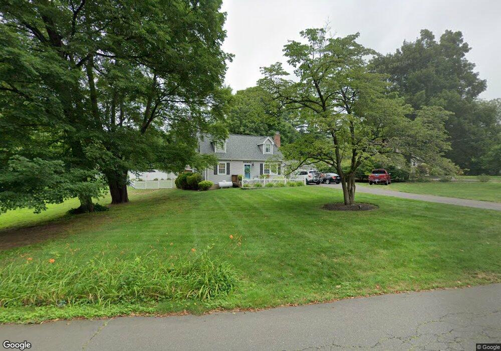
19 Oakridge Dr Granby, CT 06035
Estimated Value: $354,543 - $399,000
3
Beds
2
Baths
1,152
Sq Ft
$319/Sq Ft
Est. Value
About This Home
This home is located at 19 Oakridge Dr, Granby, CT 06035 and is currently estimated at $367,386, approximately $318 per square foot. 19 Oakridge Dr is a home located in Hartford County with nearby schools including Kelly Lane Primary School, Granby Memorial Middle School, and Granby Memorial High School.
Ownership History
Date
Name
Owned For
Owner Type
Purchase Details
Closed on
Jul 6, 2000
Sold by
Allen Joseph and Allen Lanneli
Bought by
Stone Russell and Stone Wendy
Current Estimated Value
Purchase Details
Closed on
Nov 3, 1997
Sold by
Schmahl Richard
Bought by
Allen Joseph and Allen Lanell
Purchase Details
Closed on
Oct 2, 1990
Sold by
Chatfield Elliott Est
Bought by
Schmahl Richard
Create a Home Valuation Report for This Property
The Home Valuation Report is an in-depth analysis detailing your home's value as well as a comparison with similar homes in the area
Home Values in the Area
Average Home Value in this Area
Purchase History
| Date | Buyer | Sale Price | Title Company |
|---|---|---|---|
| Stone Russell | $140,000 | -- | |
| Stone Russell | $140,000 | -- | |
| Allen Joseph | $122,200 | -- | |
| Allen Joseph | $122,200 | -- | |
| Schmahl Richard | $110,000 | -- |
Source: Public Records
Mortgage History
| Date | Status | Borrower | Loan Amount |
|---|---|---|---|
| Closed | Schmahl Richard | $38,180 | |
| Open | Schmahl Richard | $250,087 |
Source: Public Records
Tax History Compared to Growth
Tax History
| Year | Tax Paid | Tax Assessment Tax Assessment Total Assessment is a certain percentage of the fair market value that is determined by local assessors to be the total taxable value of land and additions on the property. | Land | Improvement |
|---|---|---|---|---|
| 2025 | $6,140 | $179,480 | $56,070 | $123,410 |
| 2024 | $5,946 | $179,480 | $56,070 | $123,410 |
| 2023 | $5,724 | $179,480 | $56,070 | $123,410 |
| 2022 | $5,222 | $130,620 | $48,650 | $81,970 |
| 2021 | $5,174 | $130,620 | $48,650 | $81,970 |
| 2020 | $5,174 | $130,620 | $48,650 | $81,970 |
| 2019 | $5,174 | $130,620 | $48,650 | $81,970 |
| 2018 | $5,054 | $130,620 | $48,650 | $81,970 |
| 2017 | $4,996 | $131,670 | $48,650 | $83,020 |
| 2016 | $4,864 | $131,670 | $48,650 | $83,020 |
| 2015 | $4,769 | $131,670 | $48,650 | $83,020 |
| 2014 | $4,677 | $131,670 | $48,650 | $83,020 |
Source: Public Records
Map
Nearby Homes
- 1 Rushford Meade
- 238 Salmon Brook St
- 11 Windmill Springs Unit 11
- 2 Dogwood Ct
- 77 Hunt Glen Dr
- 14 Hunt Glen Dr Unit 14
- 31 Hunt Glen Dr
- 16 Whytewood Ln
- 21 Highridge Dr
- 106 W Granby Rd
- 110 W Granby Rd
- 51 Canton Rd
- 125 N Granby Rd
- 17 Cranberry Ln
- 414 Salmon Brook St
- 6 Running Pine Rd
- 21 Newgate Rd
- 33 Whitman Dr
- 91 Turkey Hills Rd
- 277 N Granby Rd
- 25 Oakridge Dr
- 17 Oakridge Dr
- 12 Shattuck Ave
- 40 Rushford Meade
- 36 Rushford Meade
- 36 Rushford Meade Unit 36
- 8 Shattuck Ave
- 34 Rushford Meade
- 34 Rushford Meade
- 47 Rushford Meade
- 47 Rushford Meade Unit 47
- 32 Rushford Meade
- 32 Rushford Meade Unit 32
- 45 Rushford Meade
- 45 Rushford Meade Unit 45
- 20 Oakridge Dr
- 43 Rushford Meade
- 43 Rushford Meade Unit 43
- 41 Rushford Meade
- 15 Oakridge Dr