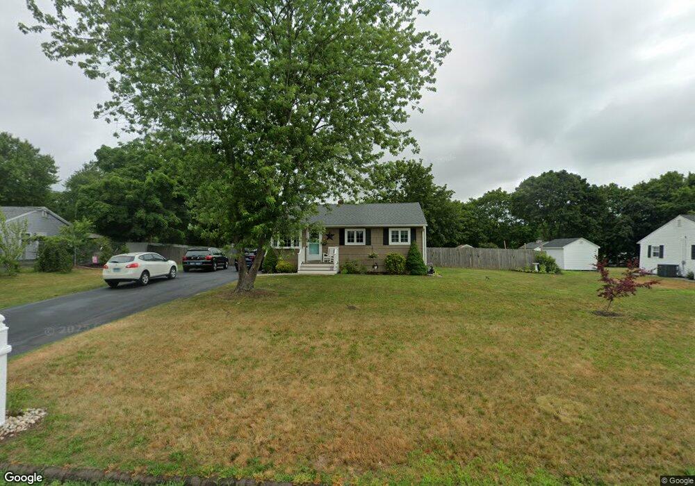
19 Pearl St North Branford, CT 06471
Estimated Value: $375,483 - $422,000
2
Beds
3
Baths
972
Sq Ft
$406/Sq Ft
Est. Value
About This Home
This home is located at 19 Pearl St, North Branford, CT 06471 and is currently estimated at $394,621, approximately $405 per square foot. 19 Pearl St is a home located in New Haven County with nearby schools including Jerome Harrison School, Totoket Valley Elementary School, and North Branford Intermediate School.
Ownership History
Date
Name
Owned For
Owner Type
Purchase Details
Closed on
Sep 24, 2019
Sold by
Furr Gary and Furr Joan
Bought by
Turcotte Nicole M
Current Estimated Value
Purchase Details
Closed on
Mar 1, 2007
Sold by
Bernick Michael J and Bernick Rischell J
Bought by
Austio Julie
Home Financials for this Owner
Home Financials are based on the most recent Mortgage that was taken out on this home.
Original Mortgage
$209,000
Interest Rate
6.25%
Create a Home Valuation Report for This Property
The Home Valuation Report is an in-depth analysis detailing your home's value as well as a comparison with similar homes in the area
Home Values in the Area
Average Home Value in this Area
Purchase History
| Date | Buyer | Sale Price | Title Company |
|---|---|---|---|
| Turcotte Nicole M | $250,000 | -- | |
| Austio Julie | $220,000 | -- |
Source: Public Records
Mortgage History
| Date | Status | Borrower | Loan Amount |
|---|---|---|---|
| Previous Owner | Austio Julie | $188,000 | |
| Previous Owner | Austio Julie | $178,400 | |
| Previous Owner | Austio Julie | $209,000 |
Source: Public Records
Tax History Compared to Growth
Tax History
| Year | Tax Paid | Tax Assessment Tax Assessment Total Assessment is a certain percentage of the fair market value that is determined by local assessors to be the total taxable value of land and additions on the property. | Land | Improvement |
|---|---|---|---|---|
| 2025 | $5,853 | $212,000 | $106,200 | $105,800 |
| 2024 | $5,041 | $140,300 | $88,500 | $51,800 |
| 2023 | $4,843 | $140,300 | $88,500 | $51,800 |
| 2022 | $4,662 | $140,300 | $88,500 | $51,800 |
| 2021 | $12,936 | $140,300 | $88,500 | $51,800 |
| 2020 | $4,570 | $136,100 | $82,700 | $53,400 |
| 2019 | $4,554 | $136,100 | $82,700 | $53,400 |
| 2018 | $4,544 | $136,100 | $82,700 | $53,400 |
| 2017 | $4,561 | $136,100 | $82,700 | $53,400 |
| 2016 | $4,352 | $136,100 | $82,700 | $53,400 |
| 2015 | $4,218 | $135,900 | $82,700 | $53,200 |
| 2014 | $4,066 | $135,900 | $82,700 | $53,200 |
Source: Public Records
Map
Nearby Homes
- 356 Totoket Rd
- 358 Totoket Rd
- 3 Borrelli Rd
- 255 Forest Rd
- 32 Branhaven Dr
- 81 Warner Rd
- 11 Williams Rd
- 29 Justine Dr
- 33 Justine Dr
- 32 Justine Dr
- 47 Summit Dr
- 20 Lombard Cir Unit 20
- 22 Lombard Cir Unit 22
- 7 Jeffrey Rd
- 4 Lombard Cir Unit 4
- 2 Lombard Cir Unit 2
- 379 Brushy Plain Rd
- 132 Linsley Lake Rd
- 7 Oak Hill Dr
- 7 Carolyn Ct