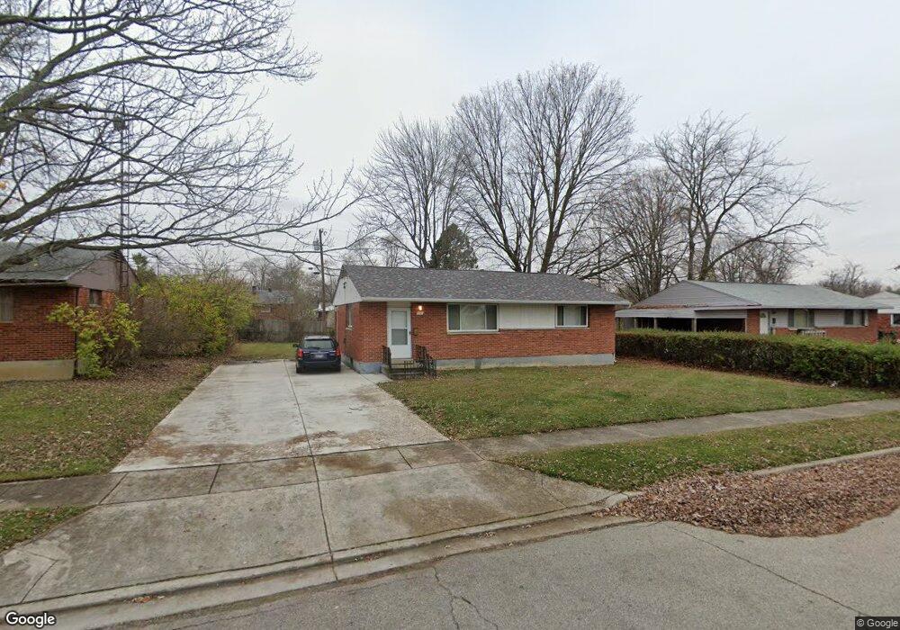
19 Stubbs Dr Dayton, OH 45426
Estimated Value: $109,000 - $148,000
3
Beds
1
Bath
1,100
Sq Ft
$117/Sq Ft
Est. Value
About This Home
This home is located at 19 Stubbs Dr, Dayton, OH 45426 and is currently estimated at $128,875, approximately $117 per square foot. 19 Stubbs Dr is a home located in Montgomery County with nearby schools including Trotwood-Madison Middle School, Trotwood-Madison High School, and Trotwood Preparatory & Fitness Academy.
Ownership History
Date
Name
Owned For
Owner Type
Purchase Details
Closed on
Dec 20, 1999
Sold by
Johnson Carlton H
Bought by
Hamilton Charles and Hamilton Charles E
Current Estimated Value
Home Financials for this Owner
Home Financials are based on the most recent Mortgage that was taken out on this home.
Original Mortgage
$56,583
Outstanding Balance
$17,486
Interest Rate
7.69%
Estimated Equity
$111,389
Purchase Details
Closed on
Apr 6, 1994
Sold by
Bartel David Newton
Bought by
Johnston Carlton H
Create a Home Valuation Report for This Property
The Home Valuation Report is an in-depth analysis detailing your home's value as well as a comparison with similar homes in the area
Home Values in the Area
Average Home Value in this Area
Purchase History
| Date | Buyer | Sale Price | Title Company |
|---|---|---|---|
| Hamilton Charles | $51,500 | -- | |
| Johnston Carlton H | -- | -- |
Source: Public Records
Mortgage History
| Date | Status | Borrower | Loan Amount |
|---|---|---|---|
| Open | Hamilton Charles | $56,583 |
Source: Public Records
Tax History Compared to Growth
Tax History
| Year | Tax Paid | Tax Assessment Tax Assessment Total Assessment is a certain percentage of the fair market value that is determined by local assessors to be the total taxable value of land and additions on the property. | Land | Improvement |
|---|---|---|---|---|
| 2024 | $1,319 | $20,170 | $4,480 | $15,690 |
| 2023 | $1,319 | $20,170 | $4,480 | $15,690 |
| 2022 | $1,326 | $15,780 | $3,500 | $12,280 |
| 2021 | $1,328 | $15,780 | $3,500 | $12,280 |
| 2020 | $1,328 | $15,780 | $3,500 | $12,280 |
| 2019 | $1,094 | $11,600 | $2,450 | $9,150 |
| 2018 | $1,095 | $11,600 | $2,450 | $9,150 |
| 2017 | $1,088 | $11,600 | $2,450 | $9,150 |
| 2016 | $1,121 | $11,970 | $3,500 | $8,470 |
| 2015 | $1,103 | $11,970 | $3,500 | $8,470 |
| 2014 | $1,103 | $11,970 | $3,500 | $8,470 |
| 2012 | -- | $19,090 | $5,430 | $13,660 |
Source: Public Records
Map
Nearby Homes
- 33 Mario Dr
- 204 E Main St
- 4 Pleasant Ave
- 17 Grand Ave
- 103 E Worley Ave
- 1 E Worley Ave
- 301 Beardsley Rd
- 0 Main
- 208 E Sunrise Ave
- 209 W Main St
- 385 Blairwood Dr
- 316 Skinner Dr
- 208 E Eppington Dr
- 717 Mapleside Dr
- 800 Chandler Dr
- 512 N Sherry Dr
- 7540 Tuscola Dr
- 6899 Little Richmond Rd
- 4051 Belmore Trace
- 0 Little Richmond Rd