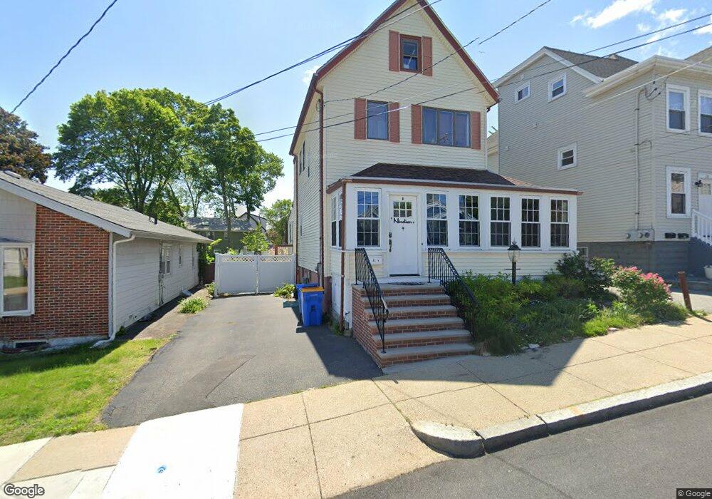
19 Thornton St Winthrop, MA 02152
Downtown Winthrop NeighborhoodEstimated Value: $665,000 - $802,000
4
Beds
2
Baths
1,601
Sq Ft
$451/Sq Ft
Est. Value
About This Home
This home is located at 19 Thornton St, Winthrop, MA 02152 and is currently estimated at $721,725, approximately $450 per square foot. 19 Thornton St is a home located in Suffolk County with nearby schools including William P. Gorman/Fort Banks Elementary School, Arthur T. Cummings Elementary School, and Winthrop Middle School.
Ownership History
Date
Name
Owned For
Owner Type
Purchase Details
Closed on
Mar 27, 2020
Sold by
19 Thornton Street T
Bought by
Soper and Stevens James
Current Estimated Value
Home Financials for this Owner
Home Financials are based on the most recent Mortgage that was taken out on this home.
Original Mortgage
$391,000
Outstanding Balance
$346,379
Interest Rate
3.4%
Mortgage Type
New Conventional
Estimated Equity
$375,346
Create a Home Valuation Report for This Property
The Home Valuation Report is an in-depth analysis detailing your home's value as well as a comparison with similar homes in the area
Home Values in the Area
Average Home Value in this Area
Purchase History
| Date | Buyer | Sale Price | Title Company |
|---|---|---|---|
| Soper | $525,000 | None Available |
Source: Public Records
Mortgage History
| Date | Status | Borrower | Loan Amount |
|---|---|---|---|
| Open | Soper | $391,000 |
Source: Public Records
Tax History
| Year | Tax Paid | Tax Assessment Tax Assessment Total Assessment is a certain percentage of the fair market value that is determined by local assessors to be the total taxable value of land and additions on the property. | Land | Improvement |
|---|---|---|---|---|
| 2025 | $6,535 | $633,200 | $332,200 | $301,000 |
| 2024 | $6,685 | $641,600 | $319,300 | $322,300 |
| 2023 | $6,223 | $581,600 | $292,300 | $289,300 |
| 2022 | $5,994 | $509,700 | $261,100 | $248,600 |
| 2021 | $5,634 | $444,300 | $233,100 | $211,200 |
| 2020 | $5,607 | $444,300 | $233,100 | $211,200 |
| 2019 | $5,480 | $415,800 | $214,800 | $201,000 |
| 2018 | $5,314 | $375,300 | $184,400 | $190,900 |
| 2017 | $4,895 | $339,700 | $163,300 | $176,400 |
| 2016 | $4,826 | $314,000 | $142,000 | $172,000 |
| 2015 | $4,382 | $305,600 | $137,900 | $167,700 |
| 2014 | $4,384 | $281,400 | $128,200 | $153,200 |
Source: Public Records
Map
Nearby Homes
- 142 Washington Ave
- 304 Shirley St
- 279 Shirley St Unit 2
- 26 Forrest St Unit 1
- 247 Washington Ave Unit 9
- 247 Washington Ave Unit 10
- 23 Trident Ave Unit 1
- 66 Plummer Ave Unit 3
- 53 Trident Ave Unit 204
- 37 Trident Ave
- 43-45 Ocean Ave
- 10 Somerset Ave Unit 403
- 10 Somerset Ave Unit 404
- 10 Somerset Ave Unit 207
- 10 Somerset Ave Unit 304
- 10 Somerset Ave Unit 408
- 10 Somerset Ave Unit 201
- 10 Somerset Ave Unit 405
- 10 Somerset Ave Unit 308
- 10 Somerset Ave Unit 211
- 23 Thornton St
- 27 Thornton St
- 15 Thornton St
- 15 Thornton St Unit 2
- 15 Thornton St Unit 1
- 50 Willow Ave
- 50 Willow Ave Unit 1
- 56 Willow Ave
- 60 Willow Ave
- 31 Thornton St Unit 33
- 33 Thornton St Unit 1
- 290 Bowdoin St
- 294 Bowdoin St
- 20 Thornton St
- 16 Thornton St
- 276 Bowdoin St
- 28 Thornton St
- 149 River Rd
- 149 River Rd Unit 1st Floor
- 149 River Rd Unit 1
Your Personal Tour Guide
Ask me questions while you tour the home.