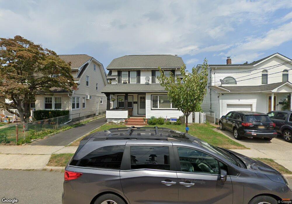
19 Wyoming Ave Lynbrook, NY 11563
Estimated Value: $637,706 - $721,000
--
Bed
2
Baths
1,445
Sq Ft
$470/Sq Ft
Est. Value
About This Home
This home is located at 19 Wyoming Ave, Lynbrook, NY 11563 and is currently estimated at $679,353, approximately $470 per square foot. 19 Wyoming Ave is a home located in Nassau County with nearby schools including East Rockaway Junior/Senior High School, Our Lady Of Peace School, and St Agnes Cathedral School.
Ownership History
Date
Name
Owned For
Owner Type
Purchase Details
Closed on
May 12, 2004
Sold by
Carini Joseph
Bought by
Chojnacki Peter
Current Estimated Value
Purchase Details
Closed on
Dec 27, 1994
Sold by
Donald William and Donald Carol
Bought by
Donald Carol and Carini Joseph
Home Financials for this Owner
Home Financials are based on the most recent Mortgage that was taken out on this home.
Original Mortgage
$75,000
Interest Rate
8.96%
Purchase Details
Closed on
Dec 19, 1994
Sold by
Terzi Anthony and Terzi Robin
Bought by
Terzi Robin
Home Financials for this Owner
Home Financials are based on the most recent Mortgage that was taken out on this home.
Original Mortgage
$75,000
Interest Rate
8.96%
Create a Home Valuation Report for This Property
The Home Valuation Report is an in-depth analysis detailing your home's value as well as a comparison with similar homes in the area
Home Values in the Area
Average Home Value in this Area
Purchase History
| Date | Buyer | Sale Price | Title Company |
|---|---|---|---|
| Chojnacki Peter | $380,000 | -- | |
| Donald Carol | -- | -- | |
| Terzi Robin | -- | -- |
Source: Public Records
Mortgage History
| Date | Status | Borrower | Loan Amount |
|---|---|---|---|
| Previous Owner | Donald Carol | $75,000 |
Source: Public Records
Tax History Compared to Growth
Tax History
| Year | Tax Paid | Tax Assessment Tax Assessment Total Assessment is a certain percentage of the fair market value that is determined by local assessors to be the total taxable value of land and additions on the property. | Land | Improvement |
|---|---|---|---|---|
| 2025 | $6,982 | $455 | $164 | $291 |
| 2024 | $697 | $455 | $164 | $291 |
| 2023 | $7,400 | $451 | $164 | $287 |
| 2022 | $7,400 | $451 | $164 | $287 |
| 2021 | $11,390 | $438 | $159 | $279 |
| 2020 | $7,451 | $748 | $363 | $385 |
| 2019 | $8,775 | $748 | $363 | $385 |
| 2018 | $7,987 | $748 | $0 | $0 |
| 2017 | $6,221 | $748 | $363 | $385 |
| 2016 | $6,965 | $748 | $363 | $385 |
| 2015 | $765 | $748 | $363 | $385 |
| 2014 | $765 | $748 | $363 | $385 |
| 2013 | $701 | $748 | $363 | $385 |
Source: Public Records
Map
Nearby Homes
- 6 Windsor Place
- 263 Village Ave
- 463 Ocean Ave
- 142 Rocklyn Ave
- 4 Hilton St
- 3 Hampton Rd
- 160 Rocklyn Ave
- 44 Jefferson Ave
- 59 Manor Rd
- 70 Denton Ave
- 44 Madison St
- 292 Ocean Ave
- 54 Lynbrook Ave
- 45 Lynbrook Ave
- 9 Christabel St
- 108 Earle Ave
- 80 Oak St
- 65 Earle Ave
- 102 S Village Ave Unit 2B
- 106 S Village Ave Unit 1D
- 13 Wyoming Ave
- 21 Wyoming Ave
- 87 Sunrise Hwy
- 25 Wyoming Ave
- 31 Wyoming Ave
- 16 Wyoming Ave
- 22 Wyoming Ave Unit 2
- 22 Wyoming Ave Unit 1
- 75 Sunrise Hwy
- 12 Wyoming Ave
- 37 Wyoming Ave
- 28 Wyoming Ave
- 10 Wyoming Ave
- 20 Exeter Ave
- 39 Wyoming Ave
- 39 Wyoming Ave Unit 2
- 6 Wyoming Ave
- 32 Wyoming Ave
- 18 Exeter Ave
- 27 Malden Ave