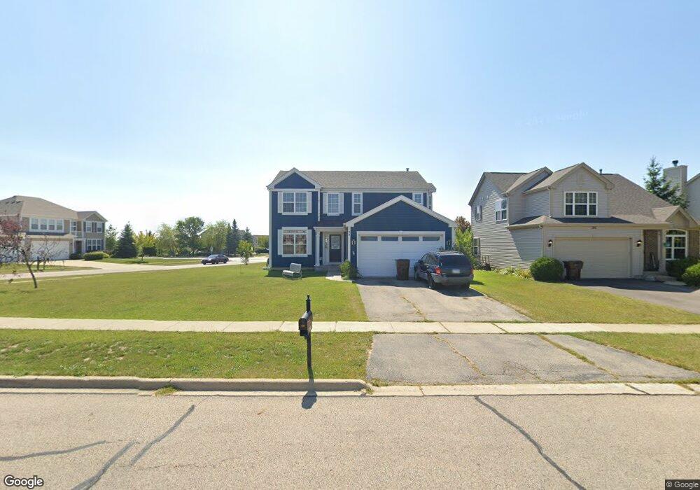
190 Bloomfield Dr Woodstock, IL 60098
Estimated Value: $407,280 - $444,000
3
Beds
3
Baths
2,435
Sq Ft
$174/Sq Ft
Est. Value
About This Home
This home is located at 190 Bloomfield Dr, Woodstock, IL 60098 and is currently estimated at $423,320, approximately $173 per square foot. 190 Bloomfield Dr is a home located in McHenry County with nearby schools including Prairiewood Elementary School, Creekside Middle School, and Woodstock High School.
Ownership History
Date
Name
Owned For
Owner Type
Purchase Details
Closed on
Jan 19, 2012
Sold by
Mosley Anthony and Mosley Maria
Bought by
Mosley Maria
Current Estimated Value
Purchase Details
Closed on
Dec 17, 2008
Sold by
Apple Creek Estates Llc
Bought by
Mosley Anthony H and Mosley Maria D
Home Financials for this Owner
Home Financials are based on the most recent Mortgage that was taken out on this home.
Original Mortgage
$290,801
Outstanding Balance
$192,709
Interest Rate
6.19%
Mortgage Type
FHA
Estimated Equity
$230,611
Create a Home Valuation Report for This Property
The Home Valuation Report is an in-depth analysis detailing your home's value as well as a comparison with similar homes in the area
Home Values in the Area
Average Home Value in this Area
Purchase History
| Date | Buyer | Sale Price | Title Company |
|---|---|---|---|
| Mosley Maria | -- | None Available | |
| Mosley Anthony H | $294,223 | First American Title Ins Co |
Source: Public Records
Mortgage History
| Date | Status | Borrower | Loan Amount |
|---|---|---|---|
| Open | Mosley Anthony H | $290,801 |
Source: Public Records
Tax History Compared to Growth
Tax History
| Year | Tax Paid | Tax Assessment Tax Assessment Total Assessment is a certain percentage of the fair market value that is determined by local assessors to be the total taxable value of land and additions on the property. | Land | Improvement |
|---|---|---|---|---|
| 2024 | $9,566 | $111,821 | $16,152 | $95,669 |
| 2023 | $9,110 | $101,123 | $14,607 | $86,516 |
| 2022 | $8,634 | $89,743 | $12,963 | $76,780 |
| 2021 | $8,216 | $83,849 | $12,112 | $71,737 |
| 2020 | $7,916 | $79,674 | $11,509 | $68,165 |
| 2019 | $7,685 | $76,054 | $10,986 | $65,068 |
| 2018 | $6,873 | $67,660 | $12,532 | $55,128 |
| 2017 | $7,066 | $66,411 | $11,795 | $54,616 |
| 2016 | $6,817 | $60,018 | $10,921 | $49,097 |
| 2013 | -- | $70,149 | $9,007 | $61,142 |
Source: Public Records
Map
Nearby Homes
- 226 Wildmeadow Ln
- 200 Macintosh Ave
- 324 Fieldstone Dr
- 339 Meadowsedge Dr
- 3405 Dean St
- 377 Fieldstone Dr
- 999 Eastwood Dr
- 00 Illinois 47
- 1522 Fox Sedge Trail
- 1500 Sandpiper Ln
- 301 Clover Chase Cir Unit 5
- 1380 Sandpiper Ln
- 2007 Edgewood Dr
- 4215 Illinois 47
- 215 Ridgewood Dr
- 421 W Kimball Ave
- 430 Laurel Ave
- 7 Galaxy Way
- 321 Hoy Ave
- 13616 Illinois 176
- 186 Bloomfield Dr
- 3080 Braeburn Way
- 182 Bloomfield Dr
- 3090 Braeburn Way
- 178 Bloomfield Dr
- 3101 Braeburn Ct
- 3070 Braeburn Way
- 189 Bloomfield Dr
- 193 Bloomfield Dr
- 185 Bloomfield Dr
- 3100 Braeburn Ct
- 181 Bloomfield Dr
- 3060 Braeburn Way
- 174 Bloomfield Dr
- 177 Bloomfield Dr
- 3111 Braeburn Ct
- 3050 Braeburn Way
- 3031 Courtland St Unit 24
- 3085 Courtland St Unit 45
- 3099 Courtland St Unit 41