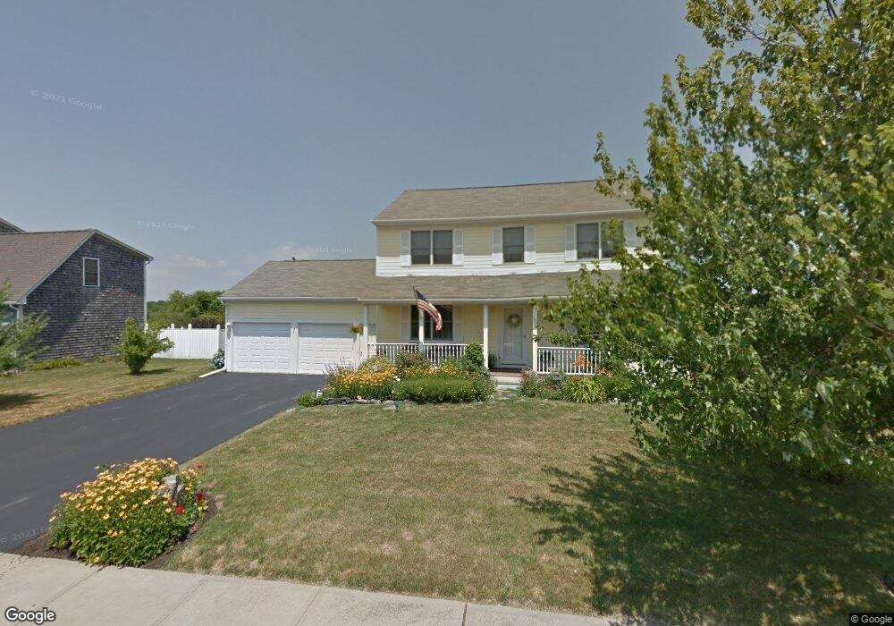
190 John Kesson Ln Middletown, RI 02842
Estimated Value: $774,427 - $1,107,000
3
Beds
3
Baths
1,920
Sq Ft
$464/Sq Ft
Est. Value
About This Home
This home is located at 190 John Kesson Ln, Middletown, RI 02842 and is currently estimated at $890,107, approximately $463 per square foot. 190 John Kesson Ln is a home located in Newport County with nearby schools including Middletown High School, All Saints STEAM Academy, and The Pennfield School.
Ownership History
Date
Name
Owned For
Owner Type
Purchase Details
Closed on
Oct 8, 2024
Sold by
Hohenleitner Ralph E and Hohenleitner Karean M
Bought by
Hohenleinter Jessica L
Current Estimated Value
Purchase Details
Closed on
Dec 22, 1999
Sold by
Kesson Farm Llc
Bought by
Hohenleitner Ralph E and Hohenleitner Karen
Home Financials for this Owner
Home Financials are based on the most recent Mortgage that was taken out on this home.
Original Mortgage
$85,000
Interest Rate
7.61%
Mortgage Type
Purchase Money Mortgage
Create a Home Valuation Report for This Property
The Home Valuation Report is an in-depth analysis detailing your home's value as well as a comparison with similar homes in the area
Home Values in the Area
Average Home Value in this Area
Purchase History
| Date | Buyer | Sale Price | Title Company |
|---|---|---|---|
| Hohenleinter Jessica L | -- | None Available | |
| Hohenleinter Jessica L | -- | None Available | |
| Hohenleitner Ralph E | $230,000 | -- | |
| Hohenleitner Ralph E | $230,000 | -- |
Source: Public Records
Mortgage History
| Date | Status | Borrower | Loan Amount |
|---|---|---|---|
| Previous Owner | Hohenleitner Ralph E | $85,000 |
Source: Public Records
Tax History Compared to Growth
Tax History
| Year | Tax Paid | Tax Assessment Tax Assessment Total Assessment is a certain percentage of the fair market value that is determined by local assessors to be the total taxable value of land and additions on the property. | Land | Improvement |
|---|---|---|---|---|
| 2024 | $7,715 | $685,200 | $326,500 | $358,700 |
| 2023 | $5,859 | $465,400 | $220,700 | $244,700 |
| 2022 | $5,594 | $465,400 | $220,700 | $244,700 |
| 2021 | $5,594 | $465,400 | $220,700 | $244,700 |
| 2020 | $5,321 | $386,700 | $165,800 | $220,900 |
| 2018 | $5,317 | $386,700 | $165,800 | $220,900 |
| 2016 | $5,580 | $361,900 | $149,200 | $212,700 |
| 2015 | $5,443 | $361,900 | $149,200 | $212,700 |
| 2014 | $5,514 | $343,100 | $128,100 | $215,000 |
| 2013 | $5,390 | $343,100 | $128,100 | $215,000 |
Source: Public Records
Map
Nearby Homes
- 103 Gossets Turn Dr
- 188 Greene Ln
- 10 J h Dwyer Dr
- 18 J h Dwyer Dr
- 68 Rebels Way
- 711 Union St
- 19 Cows Path Rd
- 278 Freedom Trail Dr
- 280 Freedom Trail Dr
- 286 Freedom Trail Dr
- 288 Freedom Trail Dr
- 8 North Dr
- 134 E Main Rd
- 1216 E Main Rd
- 6 Randall Ln
- 38 Mitchell's Ln
- 719 Forest Park
- 58 Lawton Brook Ln
- 849 Forest Park
- 836 Forest Park
- 200 John Kesson Ln
- 180 John Kesson Ln
- 191 John Kesson Ln
- 170 John Kesson Ln
- 181 John Kesson Ln
- 201 John Kesson Ln
- 165 John Kesson Ln
- 204 Pasture Farm Dr
- 192 Pasture Farm Dr
- 216 Pasture Farm Dr
- 164 Pasture Farm Dr
- 31 Christine Rd
- 161 Busher Dr
- 135 John Kesson Ln
- 130 John Kesson Ln
- 154 Pasture Farm Dr
- 90 Evelin Cir
- 32 Christine Rd
- 76 Evelin Cir
- 156 Busher Dr