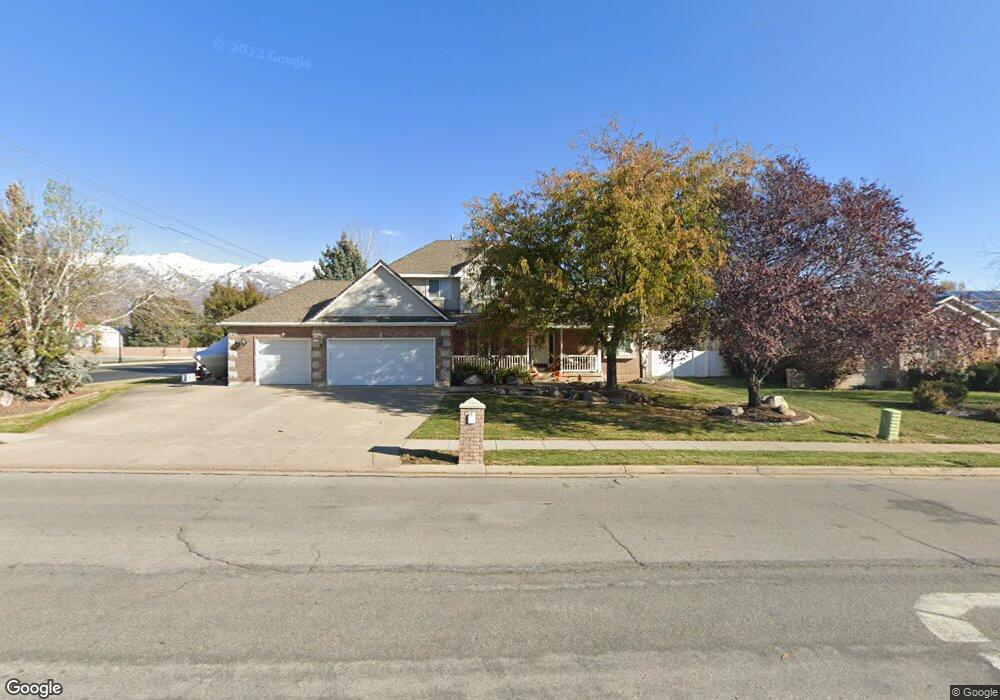
190 N Kays Dr Kaysville, UT 84037
West Kaysville NeighborhoodEstimated Value: $801,000 - $903,000
4
Beds
3
Baths
4,111
Sq Ft
$208/Sq Ft
Est. Value
About This Home
This home is located at 190 N Kays Dr, Kaysville, UT 84037 and is currently estimated at $855,184, approximately $208 per square foot. 190 N Kays Dr is a home located in Davis County with nearby schools including Kaysville Elementary School, Farmington High, and Centennial Junior High School.
Ownership History
Date
Name
Owned For
Owner Type
Purchase Details
Closed on
Jul 29, 2009
Sold by
Craig Cecil
Bought by
Kaysville City
Current Estimated Value
Purchase Details
Closed on
Feb 26, 2009
Sold by
Clark Alan L and Clark Sonja C
Bought by
Kaysville City
Purchase Details
Closed on
Feb 18, 2009
Sold by
West Darrell Ray and West Barbara
Bought by
Kaysville City
Purchase Details
Closed on
Sep 26, 1996
Sold by
Thompson Troy S and Thompson Jerilee
Bought by
Taylor Scott and Taylor Cindy
Home Financials for this Owner
Home Financials are based on the most recent Mortgage that was taken out on this home.
Original Mortgage
$198,400
Interest Rate
7.87%
Create a Home Valuation Report for This Property
The Home Valuation Report is an in-depth analysis detailing your home's value as well as a comparison with similar homes in the area
Home Values in the Area
Average Home Value in this Area
Purchase History
| Date | Buyer | Sale Price | Title Company |
|---|---|---|---|
| Kaysville City | -- | None Available | |
| Kaysville City | -- | None Available | |
| Kaysville City | -- | None Available | |
| Taylor Scott | -- | Equity Title Agency |
Source: Public Records
Mortgage History
| Date | Status | Borrower | Loan Amount |
|---|---|---|---|
| Previous Owner | Taylor Scott | $198,400 |
Source: Public Records
Tax History Compared to Growth
Tax History
| Year | Tax Paid | Tax Assessment Tax Assessment Total Assessment is a certain percentage of the fair market value that is determined by local assessors to be the total taxable value of land and additions on the property. | Land | Improvement |
|---|---|---|---|---|
| 2025 | $3,834 | $425,700 | $208,491 | $217,209 |
| 2024 | $3,834 | $404,250 | $197,084 | $207,166 |
| 2023 | $3,808 | $711,000 | $348,577 | $362,423 |
| 2022 | $3,832 | $401,500 | $190,231 | $211,269 |
| 2021 | $3,477 | $546,000 | $227,508 | $318,492 |
| 2020 | $3,152 | $482,000 | $194,700 | $287,300 |
| 2019 | $3,024 | $454,000 | $194,047 | $259,953 |
| 2018 | $2,826 | $423,000 | $164,461 | $258,539 |
| 2016 | $2,672 | $210,210 | $76,088 | $134,122 |
| 2015 | $2,546 | $190,190 | $76,088 | $114,102 |
| 2014 | $2,588 | $196,823 | $61,819 | $135,004 |
| 2013 | -- | $185,821 | $38,994 | $146,827 |
Source: Public Records
Map
Nearby Homes
- 1087 Barnes Dr
- 48 S Flint St
- 1429 W Lincoln Way
- 129 N Mountain Vistas Rd
- 917 S Main St Unit H
- 444 Creekside Way
- 454 S Jay St W
- 895 S Main St Unit E
- 424 W Creekside Ln
- 203 S Larkin Ln
- 1566 Pheasant Meadow Dr
- 680 N Main St Unit B19
- 52 S Grandison Ct E Unit 83-R
- 1346 W Blackbird Ln Unit 3
- 109 S Rock Loft Ridge Dr Unit 56-R
- 159 S Rock Loft Ridge Dr Unit 59-R
- 209 N Rock Loft Ridge E Unit 32-R
- 180 S Rock Loft Ridge Dr E Unit 7-R
- 246 N Rock Loft Ridge Dr Unit 36-R
- 22 S Rock Loft Ridge Dr Unit 16-R