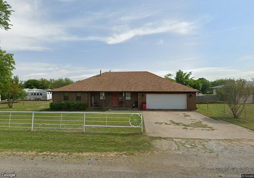
190 Preston Meadows Rd Sherman, TX 75092
Estimated Value: $488,000 - $516,363
3
Beds
2
Baths
2,355
Sq Ft
$213/Sq Ft
Est. Value
About This Home
This home is located at 190 Preston Meadows Rd, Sherman, TX 75092 and is currently estimated at $502,182, approximately $213 per square foot. 190 Preston Meadows Rd is a home located in Grayson County with nearby schools including S&S Consolidated Elementary School, S&S Consolidated Middle School, and S. & S. Cons H.S..
Ownership History
Date
Name
Owned For
Owner Type
Purchase Details
Closed on
Mar 20, 2020
Sold by
Lj Real Estate Investments Ltd
Bought by
Jordan Troy W
Current Estimated Value
Purchase Details
Closed on
Jul 15, 2015
Sold by
Azhderian Samuel Ara and Azhderian Carla
Bought by
Jordan Troy
Home Financials for this Owner
Home Financials are based on the most recent Mortgage that was taken out on this home.
Original Mortgage
$135,150
Interest Rate
4.08%
Mortgage Type
New Conventional
Purchase Details
Closed on
Sep 28, 2005
Sold by
Pattison Dewayne and Pattison Karen E
Bought by
Azhderian Samuel Ara
Home Financials for this Owner
Home Financials are based on the most recent Mortgage that was taken out on this home.
Original Mortgage
$127,200
Interest Rate
7.37%
Mortgage Type
Fannie Mae Freddie Mac
Create a Home Valuation Report for This Property
The Home Valuation Report is an in-depth analysis detailing your home's value as well as a comparison with similar homes in the area
Home Values in the Area
Average Home Value in this Area
Purchase History
| Date | Buyer | Sale Price | Title Company |
|---|---|---|---|
| Jordan Troy W | -- | Grayson County Title | |
| Jordan Troy | -- | Chapin Title Co Inc | |
| Azhderian Samuel Ara | -- | -- |
Source: Public Records
Mortgage History
| Date | Status | Borrower | Loan Amount |
|---|---|---|---|
| Previous Owner | Jordan Troy | $135,150 | |
| Previous Owner | Azhderian Samuel Ara | $127,200 |
Source: Public Records
Tax History Compared to Growth
Tax History
| Year | Tax Paid | Tax Assessment Tax Assessment Total Assessment is a certain percentage of the fair market value that is determined by local assessors to be the total taxable value of land and additions on the property. | Land | Improvement |
|---|---|---|---|---|
| 2025 | $4,640 | $439,189 | -- | -- |
| 2024 | $5,961 | $399,263 | $0 | $0 |
| 2023 | $3,548 | $323,815 | $0 | $0 |
| 2022 | $4,950 | $294,377 | $0 | $0 |
| 2021 | $5,090 | $311,347 | $84,979 | $226,368 |
| 2020 | $4,772 | $323,355 | $74,992 | $248,363 |
| 2019 | $4,570 | $330,645 | $56,019 | $274,626 |
| 2018 | $3,804 | $249,194 | $56,019 | $193,175 |
| 2017 | $3,470 | $213,314 | $41,883 | $171,431 |
| 2016 | $3,166 | $161,453 | $25,479 | $135,974 |
| 2015 | $4,592 | $232,072 | $25,492 | $206,580 |
| 2014 | $4,420 | $223,376 | $25,492 | $197,884 |
Source: Public Records
Map
Nearby Homes
- 1171 Rockport Rd
- 6514 Joyce Ln
- 00 Primrose Ln
- 3356 Old Dorchester Rd
- 586 Pleasant Home Rd
- 2615 Rolling Hills Dr
- 10.96 Acres Wible Rd
- 750 Wible Rd
- TBD Wible Rd
- 1401 Cimmaron Trail
- 3410 Old Dorchester Rd
- 1404 Tejas Dr
- TBD Taylor Rd
- 1426 S Raven Dr
- 1407 Swan Ridge Dr
- 4501 Hawk Ln
- 4507 Falcon Dr
- 6935 S Farm To Market Road 1417
- 1415 Mallard Dr
- 2134 Peggeys Cove
- 208 Preston Meadows Rd
- 199 Preston Meadows Rd
- 128 Preston Meadows Rd
- 245 Preston Meadows Rd
- 282 Preston Meadows Rd
- 94 Preston Meadows Rd
- 295 Preston Meadows Rd
- 216 Preston Meadows Rd
- 32 Preston Meadows Rd
- 327 Preston Meadows Rd
- 563 Rockport Rd
- 543 Rockport Rd
- 509 Rockport Rd
- 385 Preston Meadows Rd
- 481 Rockport Rd
- 453 Rockport Rd
- 322 Laughlin Rd
- 80 Laughlin Rd Unit R0AD
- 473 Preston Meadows Rd
- 417 Rockport Rd