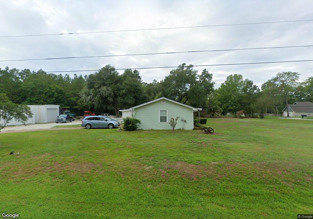
1900 Allendale Dr Lufkin, TX 75904
Estimated Value: $188,204 - $257,000
--
Bed
5
Baths
1,708
Sq Ft
$130/Sq Ft
Est. Value
About This Home
This home is located at 1900 Allendale Dr, Lufkin, TX 75904 and is currently estimated at $222,301, approximately $130 per square foot. 1900 Allendale Dr is a home located in Angelina County with nearby schools including Trout Primary School, Brookhollow Elementary School, and Lufkin Middle School.
Ownership History
Date
Name
Owned For
Owner Type
Purchase Details
Closed on
Mar 29, 2012
Sold by
Burrous Winnie L
Bought by
Forrest Darel Hogue and Forrest Crystal Elaine
Current Estimated Value
Home Financials for this Owner
Home Financials are based on the most recent Mortgage that was taken out on this home.
Original Mortgage
$63,175
Outstanding Balance
$8,107
Interest Rate
3.91%
Mortgage Type
New Conventional
Estimated Equity
$214,194
Create a Home Valuation Report for This Property
The Home Valuation Report is an in-depth analysis detailing your home's value as well as a comparison with similar homes in the area
Home Values in the Area
Average Home Value in this Area
Purchase History
| Date | Buyer | Sale Price | Title Company |
|---|---|---|---|
| Forrest Darel Hogue | -- | Security & Guaranty Abstract |
Source: Public Records
Mortgage History
| Date | Status | Borrower | Loan Amount |
|---|---|---|---|
| Open | Forrest Darel Hogue | $63,175 |
Source: Public Records
Tax History Compared to Growth
Tax History
| Year | Tax Paid | Tax Assessment Tax Assessment Total Assessment is a certain percentage of the fair market value that is determined by local assessors to be the total taxable value of land and additions on the property. | Land | Improvement |
|---|---|---|---|---|
| 2025 | $3,202 | $174,320 | $36,750 | $137,570 |
| 2024 | $2,911 | $171,510 | $36,750 | $134,760 |
| 2023 | $2,516 | $169,750 | $36,750 | $133,000 |
| 2022 | $2,622 | $134,780 | $8,840 | $125,940 |
| 2021 | $2,578 | $107,520 | $8,840 | $98,680 |
| 2020 | $2,338 | $95,130 | $8,840 | $86,290 |
| 2019 | $2,476 | $95,270 | $8,840 | $86,430 |
| 2018 | $1,805 | $92,720 | $8,840 | $83,880 |
| 2017 | $1,805 | $88,840 | $8,840 | $80,000 |
| 2016 | $1,917 | $81,910 | $8,840 | $73,070 |
| 2015 | $505 | $81,910 | $8,840 | $73,070 |
| 2014 | $505 | $66,440 | $8,840 | $57,600 |
Source: Public Records
Map
Nearby Homes
- 214 Brooks St
- 1802 Jana Dr
- 1904 S John Redditt Dr
- 825 Hanks St
- R122325 S John Redditt Dr
- 1505 S John Redditt Dr
- 1805 Hanks St
- 2302 S John Redditt Dr
- 1307 Wildbriar Dr
- 900 Wildbriar Dr
- 207 Echo Ln
- 911 Evans Dr
- 915 Evans Dr
- 01 Lane Dr
- 1108 Crooked Creek Dr
- 8 Woodhue Ct
- 309 Echo Ln
- 1201 Pierce St
- 1025 Mcgregor Dr
- 715 Pine Tree Ln