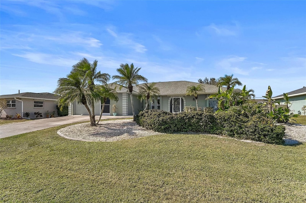
19010 Mcgrath Cir Port Charlotte, FL 33948
Estimated payment $2,454/month
Highlights
- Popular Property
- Open Floorplan
- Sun or Florida Room
- Screened Pool
- Cathedral Ceiling
- Granite Countertops
About This Home
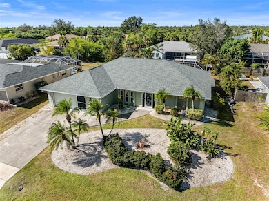
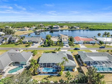
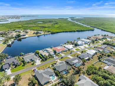
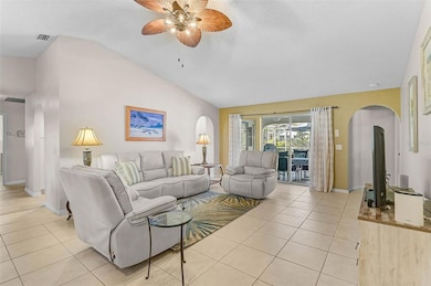
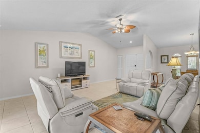
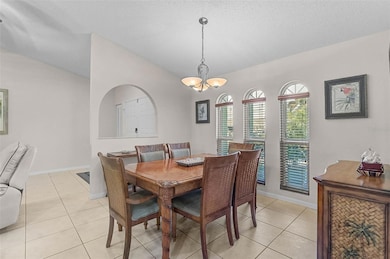
Welcome to this beautifully updated 3-bedroom, 2-bath pool home designed for relaxed Florida living. With major improvements completed throughout the home, this property offers comfort, style, and confidence for first-time homebuyers, those relocating for a fresh start, or anyone seeking the true Florida lifestyle. Recent updates include a 2023 roof, 2023 impact windows, 2023 solar pool heating system, 2022 repiping, a 2021 water heater, and a newer HVAC system. The home is also available fully furnished, providing an easy and convenient move-in option. The spacious primary suite features two walk-in closets, a private slider leading to the pool area, and an en suite bathroom with dual sinks, a large garden tub, and a separate shower. Bedroom three also includes a slider to the pool, offering flexibility for guests, extended family, or a home office with direct outdoor access. The second bathroom has pool access. The family room is bright and inviting with cathedral ceilings, a gas fireplace, and a wet bar, making it ideal for entertaining and everyday comfort. The kitchen includes granite countertops, newer cabinetry, a large peninsula for extra seating and prep space, and a built-in desk area. The kitchen opens seamlessly into the family room, while the combined living and dining room features sliding glass doors that lead to the screened lanai and pool deck. Step outside to your own private tropical oasis. The fully fenced yard is surrounded by lush landscaping, and the expansive screened-in lanai with paver pool deck offers an ideal setting for outdoor dining, relaxing, or entertaining around the solar-heated pool. The home is ideally located near Charlotte Harbor, the Sunseeker Resort, Punta Gorda Airport, beaches, parks, fishing, boating, shopping, and restaurants. Baseball fans can enjoy Tampa Bay Rays spring training at nearby Charlotte Sports Park, golfers have year-round access to Port Charlotte’s scenic courses, and outdoor enthusiasts can explore the 380-acre Tippecanoe Environmental Park with its seven miles of trails. Port Charlotte Beach Park offers another excellent spot for recreation and relaxation. This property combines thoughtful updates, a spacious layout, and an exceptional location—perfect for first-time homebuyers, those relocating, or anyone ready to enjoy the best of Florida living.
Listing Agent
WAGNER REALTY Brokerage Phone: 941-727-2800 License #3471515 Listed on: 11/17/2025

Home Details
Home Type
- Single Family
Est. Annual Taxes
- $2,294
Year Built
- Built in 1988
Lot Details
- 10,625 Sq Ft Lot
- Lot Dimensions are 85x125
- East Facing Home
- Wood Fence
- Irrigation Equipment
- Garden
- Property is zoned RSF3.5
Parking
- 2 Car Attached Garage
Home Design
- Slab Foundation
- Shingle Roof
- Concrete Siding
- Block Exterior
- Stucco
Interior Spaces
- 2,078 Sq Ft Home
- 1-Story Property
- Open Floorplan
- Wet Bar
- Built-In Desk
- Crown Molding
- Cathedral Ceiling
- Ceiling Fan
- Gas Fireplace
- Shades
- Shutters
- Blinds
- Drapes & Rods
- Sliding Doors
- Family Room Off Kitchen
- Formal Dining Room
- Sun or Florida Room
- Inside Utility
- Storm Windows
Kitchen
- Range
- Microwave
- Dishwasher
- Granite Countertops
- Disposal
Flooring
- Brick
- Ceramic Tile
- Luxury Vinyl Tile
Bedrooms and Bathrooms
- 3 Bedrooms
- Split Bedroom Floorplan
- En-Suite Bathroom
- Walk-In Closet
- 2 Full Bathrooms
- Soaking Tub
- Shower Only
- Garden Bath
Laundry
- Laundry Room
- Dryer
- Washer
Pool
- Screened Pool
- In Ground Pool
- Gunite Pool
- Fence Around Pool
- Outside Bathroom Access
Schools
- Meadow Park Elementary School
- Murdock Middle School
- Port Charlotte High School
Utilities
- Central Air
- Heating Available
- Phone Available
- Cable TV Available
Community Details
- No Home Owners Association
- Port Charlotte Subs Community
- Port Charlotte Sec 092 Subdivision
Listing and Financial Details
- Visit Down Payment Resource Website
- Legal Lot and Block 26 / 2143
- Assessor Parcel Number 402229405018
Map
Home Values in the Area
Average Home Value in this Area
Tax History
| Year | Tax Paid | Tax Assessment Tax Assessment Total Assessment is a certain percentage of the fair market value that is determined by local assessors to be the total taxable value of land and additions on the property. | Land | Improvement |
|---|---|---|---|---|
| 2025 | $2,294 | $105,391 | -- | -- |
| 2024 | $2,244 | $102,421 | -- | -- |
| 2023 | $2,244 | $99,438 | $0 | $0 |
| 2022 | $2,164 | $96,542 | $0 | $0 |
| 2021 | $2,144 | $93,730 | $0 | $0 |
| 2020 | $2,099 | $92,436 | $0 | $0 |
| 2019 | $1,439 | $90,358 | $0 | $0 |
| 2018 | $1,311 | $88,673 | $0 | $0 |
| 2017 | $1,291 | $86,849 | $0 | $0 |
| 2016 | $1,276 | $85,063 | $0 | $0 |
| 2015 | $1,260 | $84,472 | $0 | $0 |
| 2014 | $1,235 | $83,802 | $0 | $0 |
Property History
| Date | Event | Price | List to Sale | Price per Sq Ft |
|---|---|---|---|---|
| 11/17/2025 11/17/25 | For Sale | $429,900 | -- | $207 / Sq Ft |
Purchase History
| Date | Type | Sale Price | Title Company |
|---|---|---|---|
| Warranty Deed | -- | None Listed On Document | |
| Warranty Deed | $100 | Stewart Title | |
| Warranty Deed | $100 | Stewart Title | |
| Warranty Deed | $310,000 | Executive Title Ins Svcs Inc | |
| Warranty Deed | $143,000 | -- |
Mortgage History
| Date | Status | Loan Amount | Loan Type |
|---|---|---|---|
| Previous Owner | $144,000 | No Value Available | |
| Previous Owner | $144,000 | New Conventional |
Source: Stellar MLS
MLS Number: A4672167
APN: 402229405018
Disclaimer: Certain information contained herein is derived from information provided by parties other than Homes.com. All information provided is deemed reliable, but is not guaranteed to be accurate and should be independently verified.
![]() IDX information is provided exclusively for personal, non-commercial use, and may not be used for any purpose other than to identify prospective properties consumers may be interested in purchasing. Information is deemed reliable but not guaranteed.
IDX information is provided exclusively for personal, non-commercial use, and may not be used for any purpose other than to identify prospective properties consumers may be interested in purchasing. Information is deemed reliable but not guaranteed.
Listing Information presented by local MLS brokerage: Ten-X - (888)-952-6393
- 4349 Pates St
- 4318 Pates St
- 4361 Point Ct
- 18770 Mcgrath Cir
- 4310 Point Ct
- 4231 Eagle Nest Ct
- 18773 Lake Worth Blvd
- 18780 Lake Worth Blvd
- 18753 Macgill Ave
- 4501 Ewing Cir
- 18743 Macgill Ave
- 19379 Midway Blvd
- 18733 Macgill Ave
- 4204 Cockrell St
- 4213 Cockrell St
- 18716 Ohara Dr
- 18790 Countryman Ave
- 4323 Rock Creek Dr
- 4123 Corn St
- 19420 Midway Blvd
- 4342 Ewing Cir
- 18637 Lake Worth Blvd
- 18726 Countryman Ave
- 4115 Corn St
- 4147 Rock Creek Dr
- 19484 Midway Blvd
- 18608 Alphonse Cir
- 18625 Alphonse Cir
- 18606 Briggs Cir
- 4289 Yucatan Cir
- 5087 Silver Bell Dr
- 233 Chamber St NW
- 18555 Fort Smith Cir
- 4088 Gingold St
- 326 Millport St NW
- 4314 Concert St
- 334 Millport St NW
- 342 Millport St NW
- 1148 Salina Ave
- 4192 Gingold St