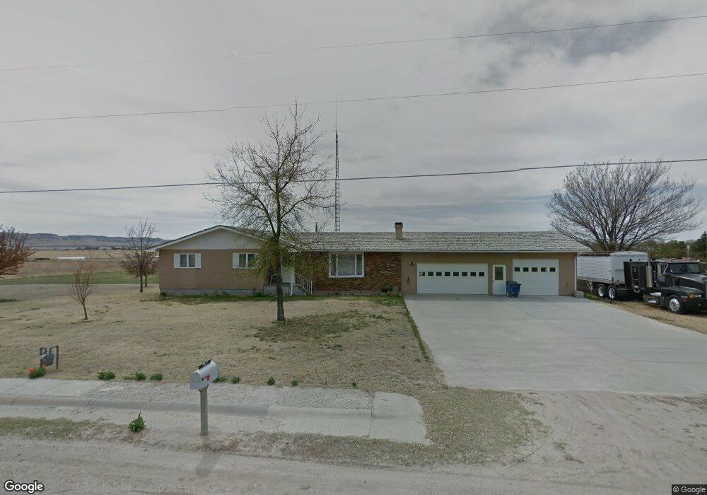
190179 University St Scottsbluff, NE 69361
Estimated Value: $229,000 - $310,000
3
Beds
2
Baths
1,605
Sq Ft
$173/Sq Ft
Est. Value
About This Home
This home is located at 190179 University St, Scottsbluff, NE 69361 and is currently estimated at $277,210, approximately $172 per square foot. 190179 University St is a home located in Scotts Bluff County with nearby schools including Lincoln Heights Elementary School, Bluffs Middle School, and Scottsbluff Senior High School.
Ownership History
Date
Name
Owned For
Owner Type
Purchase Details
Closed on
May 20, 2016
Sold by
Engledow Earl and Diamond Jana
Bought by
Grass Craig
Current Estimated Value
Purchase Details
Closed on
Aug 5, 2010
Sold by
Hunt Vernon L
Bought by
Glynn Lois E
Purchase Details
Closed on
Oct 29, 2007
Sold by
Batey Jess D and Green Catherine M
Bought by
Ashford Leighton
Purchase Details
Closed on
Apr 10, 2007
Sold by
Batey Jess D
Bought by
Batey Jess D and Green Catherine M
Purchase Details
Closed on
Sep 2, 2005
Sold by
Palmer Stephens R
Bought by
Batey Jess
Create a Home Valuation Report for This Property
The Home Valuation Report is an in-depth analysis detailing your home's value as well as a comparison with similar homes in the area
Home Values in the Area
Average Home Value in this Area
Purchase History
| Date | Buyer | Sale Price | Title Company |
|---|---|---|---|
| Grass Craig | $205,000 | Nebraska Title Company | |
| Glynn Lois E | -- | -- | |
| Ashford Leighton | $130,000 | -- | |
| Batey Jess D | $50,000 | -- | |
| Batey Jess | -- | -- |
Source: Public Records
Tax History Compared to Growth
Tax History
| Year | Tax Paid | Tax Assessment Tax Assessment Total Assessment is a certain percentage of the fair market value that is determined by local assessors to be the total taxable value of land and additions on the property. | Land | Improvement |
|---|---|---|---|---|
| 2024 | -- | $225,695 | $22,680 | $203,015 |
| 2023 | $0 | $181,066 | $14,675 | $166,391 |
| 2022 | $0 | $181,066 | $14,675 | $166,391 |
| 2021 | $2,881 | $170,192 | $14,675 | $155,517 |
| 2020 | $2,881 | $156,070 | $14,675 | $141,395 |
| 2019 | $2,881 | $176,605 | $15,570 | $161,035 |
| 2018 | $0 | $168,936 | $15,570 | $153,366 |
| 2017 | $0 | $160,275 | $15,570 | $144,705 |
| 2016 | $0 | $156,071 | $15,570 | $140,501 |
| 2015 | $2,881 | $151,979 | $15,570 | $136,409 |
| 2014 | $2,439 | $138,461 | $15,570 | $122,891 |
| 2012 | -- | $134,882 | $15,570 | $119,312 |
Source: Public Records
Map
Nearby Homes
- 190226 University St
- 2510 Kingsgate Rd
- 2317 Kingsgate Rd
- 4301 Shady Ln
- 180436 River Rd
- TBD W 36th St
- 0 W 36th St Unit 20254154
- 806 W 36th St
- 60260 Highway 71
- 10 Stoney Creek Dr
- 60043 Mccain Rd
- 414 W 33rd St
- 3017 Avenue F
- 2918 Avenue F
- 50501 County Road 20
- 2113 Avenue O
- 3415 Ross Ave
- 2809 Avenue D
- Lot 1 31st St
- TBD U S Highway 26
- 190133 University St
- 190208 University St
- 190152 University St
- 190265 University St
- 190094 University St
- 190280 University St
- 190321 University St
- 190051 University St
- 190051 University St Unit 190051 University St
- 190369 County Road H
- 190367 County Road H
- 190038 University St
- 190397 County Road H
- 190047 University St
- 190322 University St
- 190425 County Road H
- 190487 County Road H
- 190487 Cr H
- 190019 University St
- 190389 University St