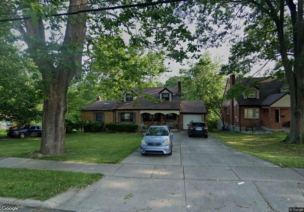
1902 Adams Rd Cincinnati, OH 45231
Estimated Value: $236,000 - $261,000
3
Beds
2
Baths
1,505
Sq Ft
$167/Sq Ft
Est. Value
About This Home
This home is located at 1902 Adams Rd, Cincinnati, OH 45231 and is currently estimated at $250,972, approximately $166 per square foot. 1902 Adams Rd is a home located in Hamilton County with nearby schools including Mt Healthy High School and Central Montessori Academy.
Ownership History
Date
Name
Owned For
Owner Type
Purchase Details
Closed on
May 8, 2000
Sold by
Boden Monica A
Bought by
Hiller Robert P and Hiller Laura A
Current Estimated Value
Home Financials for this Owner
Home Financials are based on the most recent Mortgage that was taken out on this home.
Original Mortgage
$103,200
Interest Rate
8.26%
Purchase Details
Closed on
Sep 22, 1997
Sold by
Clemens Gayle P and Clemens Robert E
Bought by
Boden Monica A
Home Financials for this Owner
Home Financials are based on the most recent Mortgage that was taken out on this home.
Original Mortgage
$109,800
Interest Rate
7.54%
Create a Home Valuation Report for This Property
The Home Valuation Report is an in-depth analysis detailing your home's value as well as a comparison with similar homes in the area
Home Values in the Area
Average Home Value in this Area
Purchase History
We collect this data history from publicly available records. To have your information removed, we recommend requesting removal directly through your county’s website.
| Date | Buyer | Sale Price | Title Company |
|---|---|---|---|
| Hiller Robert P | $129,000 | -- | |
| Boden Monica A | $122,000 | -- |
Source: Public Records
Mortgage History
We collect this data history from publicly available records. To have your information removed, we recommend requesting removal directly through your county’s website.
| Date | Status | Borrower | Loan Amount |
|---|---|---|---|
| Previous Owner | Hiller Robert P | $103,200 | |
| Previous Owner | Boden Monica A | $109,800 |
Source: Public Records
Tax History
| Year | Tax Paid | Tax Assessment Tax Assessment Total Assessment is a certain percentage of the fair market value that is determined by local assessors to be the total taxable value of land and additions on the property. | Land | Improvement |
|---|---|---|---|---|
| 2025 | $3,601 | $68,817 | $16,492 | $52,325 |
| 2023 | $3,612 | $68,817 | $16,492 | $52,325 |
| 2022 | $3,300 | $45,021 | $16,212 | $28,809 |
| 2021 | $3,219 | $45,021 | $16,212 | $28,809 |
| 2020 | $3,305 | $45,021 | $16,212 | $28,809 |
| 2019 | $2,772 | $39,841 | $14,347 | $25,494 |
| 2018 | $2,790 | $39,841 | $14,347 | $25,494 |
| 2017 | $2,632 | $39,841 | $14,347 | $25,494 |
| 2016 | $2,432 | $36,303 | $13,416 | $22,887 |
| 2015 | $2,447 | $36,303 | $13,416 | $22,887 |
| 2014 | $2,433 | $36,303 | $13,416 | $22,887 |
| 2013 | $2,737 | $41,255 | $15,246 | $26,009 |
Source: Public Records
Map
Nearby Homes
- 8001 Hamilton Ave Unit 27
- 7821 Perry St
- 2175 Carlsbory Dr
- 1524 Adams Rd
- 1545 Mcmakin Ave
- 1914 Madison Ave
- 9697 Fallsridge Ct
- 1457 Adams Rd
- 1469 Hill Ave
- 7508 Elizabeth St
- 7310 Forest Ave
- 7849 Seward Ave
- 2306 Garrison Dr
- 1461 Kinney Ave
- 616 Brightview Place Unit 28
- 610 Brightview Place Unit 31
- 624 Brightview Dr
- 626 Brightview Dr
- 610 Brightview Dr
- 622 Brightview Dr
Your Personal Tour Guide
Ask me questions while you tour the home.