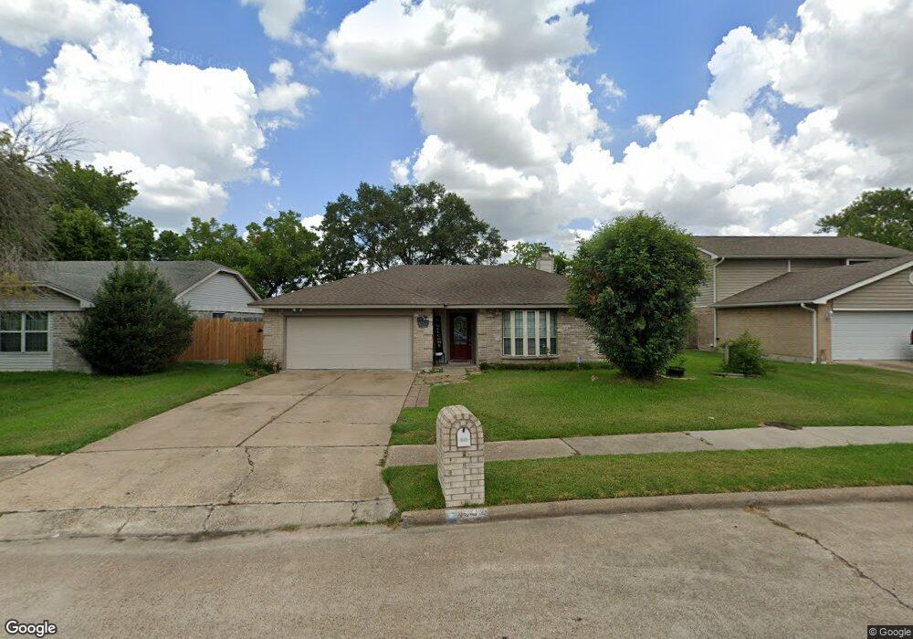
1902 Aldates Dr Houston, TX 77015
Estimated Value: $221,322 - $237,000
4
Beds
2
Baths
1,614
Sq Ft
$142/Sq Ft
Est. Value
About This Home
This home is located at 1902 Aldates Dr, Houston, TX 77015 and is currently estimated at $229,581, approximately $142 per square foot. 1902 Aldates Dr is a home located in Harris County with nearby schools including James B. Havard Elementary School, Cobb 6th Grade Campus, and North Shore Middle School.
Ownership History
Date
Name
Owned For
Owner Type
Purchase Details
Closed on
Jan 24, 2019
Sold by
Arellano Jose and Arellano Edgar
Bought by
Villarreal Victor and Villarreal Griselda
Current Estimated Value
Purchase Details
Closed on
Jul 26, 2010
Sold by
Mendez Nora
Bought by
Arellano Edgar
Purchase Details
Closed on
Mar 5, 2008
Sold by
Powell Dorothy K
Bought by
Arellano Jose and Mendez Nora
Purchase Details
Closed on
Mar 15, 2001
Sold by
Powell Dorothy K
Bought by
Powell Dorothy K and The Dorothy K Powell Revocable Living Tr
Create a Home Valuation Report for This Property
The Home Valuation Report is an in-depth analysis detailing your home's value as well as a comparison with similar homes in the area
Home Values in the Area
Average Home Value in this Area
Purchase History
| Date | Buyer | Sale Price | Title Company |
|---|---|---|---|
| Villarreal Victor | -- | Stewart Title Houston Divisi | |
| Arellano Edgar | -- | None Available | |
| Arellano Jose | -- | Texas American Title Company | |
| Powell Dorothy K | -- | -- |
Source: Public Records
Tax History Compared to Growth
Tax History
| Year | Tax Paid | Tax Assessment Tax Assessment Total Assessment is a certain percentage of the fair market value that is determined by local assessors to be the total taxable value of land and additions on the property. | Land | Improvement |
|---|---|---|---|---|
| 2025 | $4,757 | $196,818 | $41,582 | $155,236 |
| 2024 | $4,757 | $213,773 | $41,582 | $172,191 |
| 2023 | $4,757 | $221,951 | $41,582 | $180,369 |
| 2022 | $4,420 | $182,249 | $41,582 | $140,667 |
| 2021 | $4,270 | $159,963 | $41,582 | $118,381 |
| 2020 | $4,011 | $139,934 | $41,582 | $98,352 |
| 2019 | $3,207 | $130,233 | $41,582 | $88,651 |
| 2018 | $1,336 | $95,967 | $18,345 | $77,622 |
| 2017 | $2,966 | $95,967 | $18,345 | $77,622 |
| 2016 | $2,966 | $95,967 | $18,345 | $77,622 |
| 2015 | $2,436 | $98,522 | $9,173 | $89,349 |
| 2014 | $2,436 | $87,074 | $9,173 | $77,901 |
Source: Public Records
Map
Nearby Homes
- 1915 Aldates Dr
- 14847 Shottery Dr
- 14854 Shottery Dr
- 14807 Shottery Dr
- 1610 Evesham Dr
- 15602 Egret Field Ln
- 1423 Seafield Dr
- 14808 Welbeck Dr
- 15822 Mesenbrink Ln
- 15835 Flagstone Walk Way
- 15703 Granite Mountain Trail
- 111 Ambershadow Dr
- 1303 Sterling Green Ct
- 1346 Castle Glen Dr
- 1342 Castle Glen Dr
- 14806 Beaconsfield Dr
- 16007 Makayla Dr
- 14615 Woodmaple Ct
- 218 Magnolia Grove Ln
- 14835 Scotter Dr
- 1834 Aldates Dr
- 1906 Aldates Dr
- 1830 Aldates Dr
- 1902 Merton Ct
- 14831 Selwyn Dr
- 14834 Selwyn Dr
- 1906 Merton Ct
- 1826 Aldates Dr
- 14830 Selwyn Dr
- 14827 Selwyn Dr
- 1822 Aldates Dr
- 1830 Merton Dr
- 14863 Waterside Dr
- 14826 Selwyn Dr
- 1907 Merton Ct
- 14859 Waterside Dr
- 14823 Selwyn Dr
- 1818 Aldates Dr
- 1826 Merton Dr
- 14902 Waterside Dr