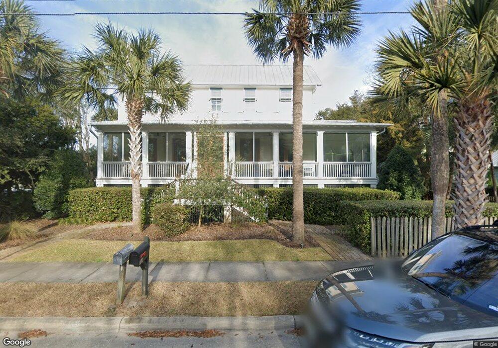
1902 Middle St Unit 1002 Sullivans Island, SC 29482
Sullivan's Island NeighborhoodEstimated Value: $4,122,000 - $5,199,000
4
Beds
3
Baths
2,324
Sq Ft
$2,039/Sq Ft
Est. Value
About This Home
This home is located at 1902 Middle St Unit 1002, Sullivans Island, SC 29482 and is currently estimated at $4,738,106, approximately $2,038 per square foot. 1902 Middle St Unit 1002 is a home located in Charleston County with nearby schools including Sullivans Island Elementary School, Moultrie Middle School, and Wando High School.
Ownership History
Date
Name
Owned For
Owner Type
Purchase Details
Closed on
Dec 16, 2009
Sold by
Zoukis Stephen J
Bought by
Zoukis Suzan Moore
Current Estimated Value
Purchase Details
Closed on
Mar 13, 2007
Sold by
Jeffords John A
Bought by
Raven Cliff Zm Llc
Purchase Details
Closed on
Apr 23, 2004
Sold by
Two Creek Llc
Bought by
Jeffords John A
Purchase Details
Closed on
Oct 24, 2001
Sold by
Betts W Earle
Bought by
Two Creek Llc
Purchase Details
Closed on
Oct 5, 2001
Sold by
Moore Louisa R
Bought by
Betts W Earle
Create a Home Valuation Report for This Property
The Home Valuation Report is an in-depth analysis detailing your home's value as well as a comparison with similar homes in the area
Home Values in the Area
Average Home Value in this Area
Purchase History
| Date | Buyer | Sale Price | Title Company |
|---|---|---|---|
| Zoukis Suzan Moore | -- | -- | |
| Zoukis Stephen J | -- | -- | |
| Raven Cliff Company Llc | -- | -- | |
| Raven Cliff Zm Llc | $1,350,000 | None Available | |
| Jeffords John A | $1,100,000 | -- | |
| Two Creek Llc | -- | -- | |
| Betts W Earle | $950,000 | -- |
Source: Public Records
Tax History Compared to Growth
Tax History
| Year | Tax Paid | Tax Assessment Tax Assessment Total Assessment is a certain percentage of the fair market value that is determined by local assessors to be the total taxable value of land and additions on the property. | Land | Improvement |
|---|---|---|---|---|
| 2024 | $53,549 | $180,960 | $0 | $0 |
| 2023 | $48,454 | $120,640 | $0 | $0 |
| 2022 | $13,591 | $120,640 | $0 | $0 |
| 2021 | $14,086 | $120,640 | $0 | $0 |
| 2020 | $14,375 | $120,640 | $0 | $0 |
| 2019 | $12,244 | $107,000 | $0 | $0 |
| 2017 | $10,794 | $107,000 | $0 | $0 |
| 2016 | $10,281 | $107,000 | $0 | $0 |
| 2015 | $10,758 | $107,000 | $0 | $0 |
| 2014 | $9,476 | $0 | $0 | $0 |
| 2011 | -- | $0 | $0 | $0 |
Source: Public Records
Map
Nearby Homes
- 2002 Ion Ave
- 1773 Atlantic Ave
- 1749 Middle St
- 1750 Ion Ave
- 189 Station 18 St
- 1714 Middle St
- 1727 Atlantic Ave
- 409 Station 22 1 2 St
- 1651 Atlantic Ave
- 2307 Ion Ave
- 2414 Goldbug Ave
- 2424 Middle St
- 2524 Middle St
- 1666 Marsh Harbor Ln Unit 101
- 2629 Goldbug Ave
- 2630 Bayonne Ave
- 0 Middle St
- 1647 Marsh Harbor Ln
- 1608 Marsh Harbor Ln Unit C
- 1606 Marsh Harbor Ln Unit C
- 1908 Middle St
- 1901 Middle St
- 226 Station 19 St
- 1908 Ion Ave
- 1856 Ion Ave
- 1856 Ion Ave Unit A
- 1856 Ion Ave Unit B (Down)
- 1856 Ion Ave Unit B
- 1914 Middle St
- 1902 Ion Ave
- 1850 Middle St
- 1914 Ion Ave
- 1850 Ion Ave
- 1856 Central Ave
- 305 Station 20 St
- 1902 Central Ave Unit A
- 1918 Ion Ave
- 1908 Central Ave
- 322 Station 19 St Unit B
- 1901 Ion Ave