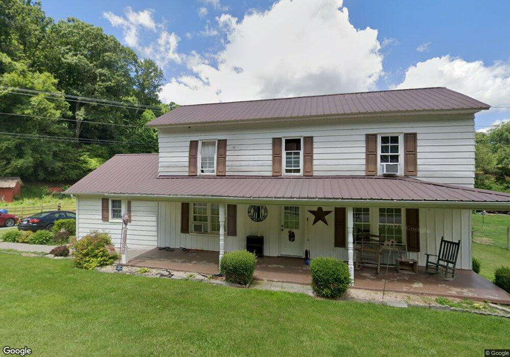
1903 Red Stone Rd Chilhowie, VA 24319
Estimated Value: $231,532 - $353,000
3
Beds
2
Baths
1,949
Sq Ft
$144/Sq Ft
Est. Value
About This Home
This home is located at 1903 Red Stone Rd, Chilhowie, VA 24319 and is currently estimated at $281,383, approximately $144 per square foot. 1903 Red Stone Rd is a home located in Smyth County with nearby schools including Chilhowie Elementary School, Chilhowie Middle School, and Chilhowie High School.
Ownership History
Date
Name
Owned For
Owner Type
Purchase Details
Closed on
Apr 13, 2016
Sold by
Jones Farrell L and Jones Julia B
Bought by
Tibbs Linda S
Current Estimated Value
Home Financials for this Owner
Home Financials are based on the most recent Mortgage that was taken out on this home.
Original Mortgage
$174,652
Outstanding Balance
$138,568
Interest Rate
3.64%
Mortgage Type
New Conventional
Estimated Equity
$142,815
Purchase Details
Closed on
Jun 22, 2005
Sold by
Federal National Mortgage Association
Bought by
Jones Farrell L and Jones Julia B
Home Financials for this Owner
Home Financials are based on the most recent Mortgage that was taken out on this home.
Original Mortgage
$143,000
Interest Rate
5.99%
Mortgage Type
Adjustable Rate Mortgage/ARM
Create a Home Valuation Report for This Property
The Home Valuation Report is an in-depth analysis detailing your home's value as well as a comparison with similar homes in the area
Home Values in the Area
Average Home Value in this Area
Purchase History
| Date | Buyer | Sale Price | Title Company |
|---|---|---|---|
| Tibbs Linda S | $168,500 | Attorney | |
| Jones Farrell L | -- | -- |
Source: Public Records
Mortgage History
| Date | Status | Borrower | Loan Amount |
|---|---|---|---|
| Open | Tibbs Linda S | $174,652 | |
| Previous Owner | Jones Farrell L | $143,000 |
Source: Public Records
Tax History Compared to Growth
Tax History
| Year | Tax Paid | Tax Assessment Tax Assessment Total Assessment is a certain percentage of the fair market value that is determined by local assessors to be the total taxable value of land and additions on the property. | Land | Improvement |
|---|---|---|---|---|
| 2025 | $904 | $153,200 | $33,000 | $120,200 |
| 2024 | $904 | $153,200 | $33,000 | $120,200 |
| 2023 | $695 | $105,400 | $30,000 | $75,400 |
| 2022 | $695 | $105,400 | $30,000 | $75,400 |
| 2021 | $695 | $105,400 | $30,000 | $75,400 |
| 2020 | $695 | $105,400 | $30,000 | $75,400 |
| 2019 | $649 | $99,100 | $30,000 | $69,100 |
| 2018 | $649 | $99,100 | $30,000 | $69,100 |
| 2017 | $649 | $99,100 | $30,000 | $69,100 |
| 2016 | $733 | $99,100 | $30,000 | $69,100 |
| 2015 | $733 | $0 | $0 | $0 |
| 2014 | $744 | $0 | $0 | $0 |
Source: Public Records
Map
Nearby Homes
- 450 Stoney Battery Rd
- 556 Stoney Battery Rd
- 265 Flatwoods Rd
- 625 Belle Hollow Rd
- 244 Rosenbaum Hollow Ln
- TBD Granite Ln
- 513 Adwolfe Rd
- tbd Chestnut Ridge Rd
- 1295 Chestnut Ridge Rd
- 1219 Chestnut Ridge Rd
- 454 Old Airport Rd
- 1055 Saint Clairs Creek Rd
- TBD Saint Clairs Creek Rd
- 182 Saint Johns Way
- 0.46 AC Brentwood Ln
- 1364 Saint Clairs Creek Rd
- 154 North Dr
- 158 North Dr
- 251 Ramblewood Rd
- 139 Brooke St
- 1911 Red Stone Rd
- 1920 Red Stone Rd
- 1921 Red Stone Rd
- 1918 Red Stone Rd
- 1934 Red Stone Rd
- 1839 Red Stone Rd
- 1814 Red Stone Rd
- 113 R L Dr
- 122 S Fork Rd
- 162 Old Mill Rd
- 152 Old Mill Rd
- 188 Old Mill Rd
- 194 Old Mill Rd
- 179 Old Mill Rd
- 135 S Fork Rd
- 104 Old Mill Rd
- 109 S Fork Rd
- 112 R L Dr
- 117 Old Mill Rd
- 159 Old Mill Rd