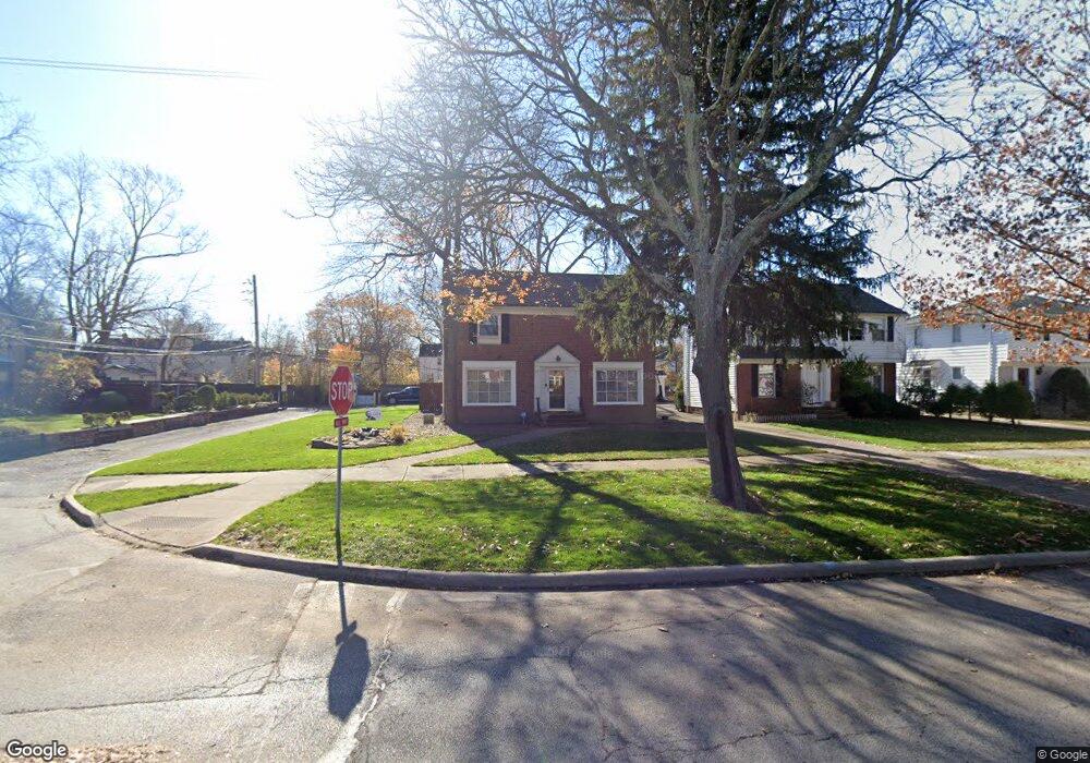
19030 Scottsdale Blvd Shaker Heights, OH 44122
Estimated Value: $270,000 - $285,793
3
Beds
2
Baths
1,930
Sq Ft
$143/Sq Ft
Est. Value
About This Home
This home is located at 19030 Scottsdale Blvd, Shaker Heights, OH 44122 and is currently estimated at $276,448, approximately $143 per square foot. 19030 Scottsdale Blvd is a home located in Cuyahoga County with nearby schools including Lomond Elementary School, Woodbury Elementary School, and Shaker Heights Middle School.
Ownership History
Date
Name
Owned For
Owner Type
Purchase Details
Closed on
Aug 15, 2013
Sold by
Estate Of Vera Plaxico Prince
Bought by
Prince Mahoney Angela and Prince Thomas Cheryl
Current Estimated Value
Purchase Details
Closed on
Jan 6, 2004
Sold by
Estate Of Moses Prince Jr
Bought by
Prince Vera P
Purchase Details
Closed on
Dec 28, 2002
Sold by
Thomas Cheryl Prince and Mahoney Angela Prince
Bought by
Prince Vera P
Purchase Details
Closed on
Apr 4, 2002
Sold by
Prince Vera P
Bought by
Thomas Cheryl Prince and Mahoney Angela Prince
Purchase Details
Closed on
Feb 1, 2002
Sold by
Estate Of Moses Prince
Bought by
Prince Vera P
Purchase Details
Closed on
Jan 1, 1975
Bought by
Prince Moses Jr & V P
Create a Home Valuation Report for This Property
The Home Valuation Report is an in-depth analysis detailing your home's value as well as a comparison with similar homes in the area
Home Values in the Area
Average Home Value in this Area
Purchase History
| Date | Buyer | Sale Price | Title Company |
|---|---|---|---|
| Prince Mahoney Angela | -- | Public | |
| Prince Vera P | -- | -- | |
| Prince Vera P | -- | -- | |
| Thomas Cheryl Prince | -- | -- | |
| Prince Vera P | -- | -- | |
| Prince Moses Jr & V P | -- | -- |
Source: Public Records
Tax History Compared to Growth
Tax History
| Year | Tax Paid | Tax Assessment Tax Assessment Total Assessment is a certain percentage of the fair market value that is determined by local assessors to be the total taxable value of land and additions on the property. | Land | Improvement |
|---|---|---|---|---|
| 2024 | $6,506 | $71,470 | $20,510 | $50,960 |
| 2023 | $5,709 | $49,980 | $16,520 | $33,460 |
| 2022 | $5,592 | $49,980 | $16,520 | $33,460 |
| 2021 | $5,573 | $49,980 | $16,520 | $33,460 |
| 2020 | $5,368 | $45,430 | $15,020 | $30,420 |
| 2019 | $5,292 | $129,800 | $42,900 | $86,900 |
| 2018 | $5,932 | $45,430 | $15,020 | $30,420 |
| 2017 | $4,758 | $38,500 | $14,840 | $23,660 |
| 2016 | $6,854 | $55,790 | $14,840 | $40,950 |
| 2015 | $13,836 | $55,790 | $14,840 | $40,950 |
| 2014 | $13,836 | $54,710 | $14,560 | $40,150 |
Source: Public Records
Map
Nearby Homes
- 19110 Lanbury Ave
- 3696 Tolland Rd
- 19302 Shakerwood Rd
- 3846 E 189th St
- 3676 Rawnsdale Rd
- 3635 Tolland Rd
- 19901 Lanbury Ave
- 19912 Lanbury Ave
- 3717 Gridley Rd
- 3651 Rawnsdale Rd
- 3609 Stoer Rd
- 19024 Lomond Blvd
- 3656 Latimore Rd
- 18302 Scottsdale Blvd
- 19112 Kings Hwy
- 18515 Lomond Blvd
- 19617 Lomond Blvd
- 18107 Scottsdale Blvd
- 18112 Lomond Blvd
- 3638 Glencairn Rd
- 19024 Scottsdale Blvd
- 19206 Scottsdale Blvd
- 19119 Wickfield Ave
- 19205 Wickfield Ave
- 19115 Wickfield Ave
- 19214 Scottsdale Blvd
- 19209 Wickfield Ave
- 19014 Scottsdale Blvd
- 19111 Wickfield Ave
- 19213 Wickfield Ave
- 19107 Wickfield Ave
- 19220 Scottsdale Blvd
- 19008 Scottsdale Blvd
- 19219 Wickfield Ave
- 19029 Scottsdale Blvd
- 19023 Scottsdale Blvd
- 19101 Wickfield Ave
- 19205 Scottsdale Blvd
- 19226 Scottsdale Blvd
- 19303 Wickfield Ave