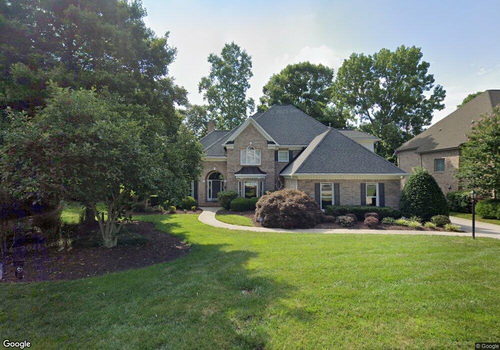
19031 Wildcat Trail Davidson, NC 28036
Estimated Value: $1,328,000 - $1,654,000
4
Beds
4
Baths
3,954
Sq Ft
$363/Sq Ft
Est. Value
About This Home
This home is located at 19031 Wildcat Trail, Davidson, NC 28036 and is currently estimated at $1,435,443, approximately $363 per square foot. 19031 Wildcat Trail is a home located in Mecklenburg County with nearby schools including Davidson Elementary School, William Amos Hough High School, and Lakeside Charter Academy.
Ownership History
Date
Name
Owned For
Owner Type
Purchase Details
Closed on
Mar 29, 2023
Sold by
Michael Alan and Michael Mary Anne
Bought by
Michael Family Trust
Current Estimated Value
Purchase Details
Closed on
Dec 21, 2006
Sold by
Troth Paula C
Bought by
Michael Alan and Michael Mary Anne
Home Financials for this Owner
Home Financials are based on the most recent Mortgage that was taken out on this home.
Original Mortgage
$350,000
Interest Rate
6.1%
Mortgage Type
Purchase Money Mortgage
Purchase Details
Closed on
Sep 1, 2005
Sold by
Troth Michael A
Bought by
Troth Paula C
Create a Home Valuation Report for This Property
The Home Valuation Report is an in-depth analysis detailing your home's value as well as a comparison with similar homes in the area
Home Values in the Area
Average Home Value in this Area
Purchase History
| Date | Buyer | Sale Price | Title Company |
|---|---|---|---|
| Michael Family Trust | -- | None Listed On Document | |
| Michael Alan | $675,000 | None Available | |
| Troth Paula C | -- | -- |
Source: Public Records
Mortgage History
| Date | Status | Borrower | Loan Amount |
|---|---|---|---|
| Previous Owner | Michael Alan | $350,000 |
Source: Public Records
Tax History
| Year | Tax Paid | Tax Assessment Tax Assessment Total Assessment is a certain percentage of the fair market value that is determined by local assessors to be the total taxable value of land and additions on the property. | Land | Improvement |
|---|---|---|---|---|
| 2025 | $8,059 | $1,069,200 | $240,000 | $829,200 |
| 2024 | $8,059 | $1,069,200 | $240,000 | $829,200 |
| 2023 | $7,947 | $1,069,200 | $240,000 | $829,200 |
| 2022 | $6,958 | $734,500 | $200,000 | $534,500 |
| 2021 | $6,902 | $734,500 | $200,000 | $534,500 |
| 2020 | $6,902 | $734,500 | $200,000 | $534,500 |
| 2019 | $6,896 | $734,500 | $200,000 | $534,500 |
| 2018 | $7,224 | $596,300 | $160,000 | $436,300 |
| 2017 | $7,176 | $596,300 | $160,000 | $436,300 |
| 2016 | $7,173 | $596,300 | $160,000 | $436,300 |
| 2015 | $7,169 | $596,300 | $160,000 | $436,300 |
| 2014 | $7,167 | $0 | $0 | $0 |
Source: Public Records
Map
Nearby Homes
- 19016 Wildcat Trail
- 19310 River Falls Dr
- 18908 Riverwind Ln
- 15107 Rocky Bluff Loop
- 14536 E Rocky River Rd
- 14532 E Rocky River Rd
- 18800 Boundary Oaks Ct
- 16117 Halle Marie Cir
- 13446 Scanlan Way
- 14325 E Rocky River Rd
- 17928 Pages Pond Ct
- 13417 Scanlan Way
- 18530 Carnegie Overlook Blvd
- 14105 Ryker Way
- 15615 E Rocky River Rd
- 18624 Silent Falls Cove
- 17422 Shearer Rd
- 15910 Heath Aster Way
- 11445 Prosperity Church Rd
- 11443 Prosperity Church Rd
- 19023 Wildcat Trail
- 19015 Wildcat Trail
- 19032 Wildcat Trail
- 19119 Wildcat Trail
- 19024 Wildcat Trail
- 19108 Wildcat Trail
- 19009 Wildcat Trail
- 19631 River Falls Dr
- 19701 River Falls Dr
- 19625 River Falls Dr
- 19007 Hodestone Mews Ct
- 19001 Wildcat Trail
- 19011 Hodestone Mews Ct
- 19003 Hodestone Mews Ct
- 19509 River Falls Dr
- 19630 River Falls Dr
- 19702 River Falls Dr
- 19600 River Falls Dr
- 19712 River Falls Dr
- 19004 Hodestone Mews Ct
Your Personal Tour Guide
Ask me questions while you tour the home.