1904 Queensway Dundalk, MD 21222
Estimated Value: $190,315 - $272,000
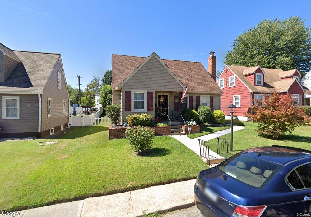
About This Home
This home is located at 1904 Queensway, Dundalk, MD 21222 and is currently estimated at $243,829, approximately $183 per square foot. 1904 Queensway is a home located in Baltimore County with nearby schools including Dundalk Elementary, Dundalk Middle School, and Dundalk High School.
Ownership History
We collect this data history from publicly available records. To have your information removed, we recommend requesting removal directly through your county’s website.
Purchase Details
Purchase Details
Home Financials for this Owner
Home Financials are based on the most recent Mortgage that was taken out on this home.Purchase Details
Home Values in the Area
Average Home Value in this Area
Purchase History
We collect this data history from publicly available records. To have your information removed, we recommend requesting removal directly through your county’s website.
| Date | Buyer | Sale Price | Title Company |
|---|---|---|---|
| -- | None Listed On Document | ||
| -- | None Available | ||
| $13,800 | -- |
Mortgage History
We collect this data history from publicly available records. To have your information removed, we recommend requesting removal directly through your county’s website.
| Date | Status | Borrower | Loan Amount |
|---|---|---|---|
| Previous Owner | $80,000 |
Tax History
We collect this data history from publicly available records. To have your information removed, we recommend requesting removal directly through your county’s website.
| Year | Tax Paid | Tax Assessment Tax Assessment Total Assessment is a certain percentage of the fair market value that is determined by local assessors to be the total taxable value of land and additions on the property. | Land | Improvement |
|---|---|---|---|---|
| 2025 | $2,380 | $168,567 | -- | -- |
| 2024 | $2,380 | $159,533 | $0 | $0 |
| 2023 | $1,198 | $150,500 | $50,000 | $100,500 |
| 2022 | $2,313 | $143,167 | $0 | $0 |
| 2021 | $2,193 | $135,833 | $0 | $0 |
| 2020 | $2,193 | $128,500 | $50,000 | $78,500 |
| 2019 | $2,047 | $124,167 | $0 | $0 |
| 2018 | $1,868 | $119,833 | $0 | $0 |
| 2017 | $1,777 | $115,500 | $0 | $0 |
| 2016 | $1,717 | $113,600 | $0 | $0 |
| 2015 | $1,717 | $111,700 | $0 | $0 |
| 2014 | $1,717 | $109,800 | $0 | $0 |
Map
- 1919 Maxwell Ave
- 1925 Queensway
- 1823 Dundalk Ave
- 1817 Maxwell Ave
- 17 Sollers Point Rd
- 6735 Oak Ave
- 6904 Homeway
- 2411 Fairway
- 62 Yorkway
- 1910 Tyler Rd
- 106 Kinship Rd
- 6526 Detroit Ave
- 1801 Tolson Ave
- 101 Willow Spring Rd
- 1603 Malvern St
- 2504 Liberty Pkwy
- 1613 Dundalk Ave
- 6632 Hartwait St
- 6520 Eastbourne Ave
- 6750 Railway Ave
- 1928 Maxwell Ave
- 1926 Maxwell Ave
- 1932 Maxwell Ave
- 1924 Maxwell Ave
- 1936 Maxwell Ave
- 1920 Maxwell Ave
- 1923 Dundalk Ave
- 1921 Dundalk Ave
- 1927 Dundalk Ave
- 1938 Maxwell Ave
- 1919 Dundalk Ave
- 1929 Dundalk Ave
- 1923 Maxwell Ave
- 1900 Queensway
- 1917 Dundalk Ave
- 1940 Maxwell Ave
- 1931 Dundalk Ave
- 1916 Maxwell Ave
- 1906 Queensway
- 1933 Dundalk Ave
Ask me questions while you tour the home.