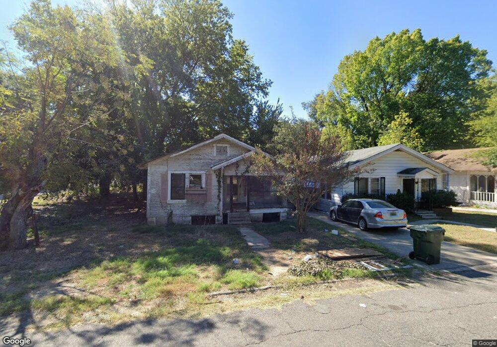
1905 Anna St Shreveport, LA 71101
Allendale-Lakeside NeighborhoodEstimated Value: $35,134 - $53,000
3
Beds
1
Bath
895
Sq Ft
$52/Sq Ft
Est. Value
About This Home
This home is located at 1905 Anna St, Shreveport, LA 71101 and is currently estimated at $46,284, approximately $51 per square foot. 1905 Anna St is a home with nearby schools including Judson Fundamental Elementary School, South Highlands Elementary, and Fairfield Magnet School.
Ownership History
Date
Name
Owned For
Owner Type
Purchase Details
Closed on
Mar 18, 2010
Sold by
High Sierra Tax Sale Properties Llc
Bought by
Pintail Holdings Llc
Current Estimated Value
Purchase Details
Closed on
Mar 12, 2010
Sold by
High Sierra Tax Sale Properties Llc
Bought by
Pintail Holdings Llc
Purchase Details
Closed on
Jun 14, 2007
Sold by
High Sierra Tax Sale Properties Llc
Bought by
Zydeco 4 Llc
Purchase Details
Closed on
Jun 8, 2007
Sold by
High Sierra Tax Sale Properties Llc
Bought by
Zydeco 2
Purchase Details
Closed on
Jun 2, 2006
Sold by
Mack Clara F
Bought by
High Sterra Tax Sale Properties Llc
Create a Home Valuation Report for This Property
The Home Valuation Report is an in-depth analysis detailing your home's value as well as a comparison with similar homes in the area
Home Values in the Area
Average Home Value in this Area
Purchase History
| Date | Buyer | Sale Price | Title Company |
|---|---|---|---|
| Pintail Holdings Llc | -- | None Available | |
| Pintail Holdings Llc | -- | None Available | |
| Zydeco 4 Llc | $119 | None Available | |
| Zydeco 2 | -- | None Available | |
| High Sterra Tax Sale Properties Llc | $340 | None Available |
Source: Public Records
Tax History Compared to Growth
Tax History
| Year | Tax Paid | Tax Assessment Tax Assessment Total Assessment is a certain percentage of the fair market value that is determined by local assessors to be the total taxable value of land and additions on the property. | Land | Improvement |
|---|---|---|---|---|
| 2024 | $249 | $1,600 | $348 | $1,252 |
| 2023 | $255 | $1,600 | $348 | $1,252 |
| 2022 | $255 | $1,600 | $348 | $1,252 |
| 2021 | $251 | $1,600 | $348 | $1,252 |
| 2020 | $251 | $1,600 | $348 | $1,252 |
| 2019 | $259 | $1,600 | $348 | $1,252 |
| 2018 | $206 | $1,600 | $348 | $1,252 |
| 2017 | $263 | $1,600 | $348 | $1,252 |
| 2015 | $236 | $1,818 | $348 | $1,470 |
| 2014 | $238 | $1,820 | $350 | $1,470 |
| 2013 | -- | $1,820 | $350 | $1,470 |
Source: Public Records
Map
Nearby Homes
- 1933 Milam St
- 1943 Milam St
- 2017 Looney St
- 1644 Looney St
- 1656 Looney St
- 1680 Looney St
- 1734 Ashton St
- 309 Oregon Ave
- 937 Lewis Place
- 1726 Murphy St
- 2740 Murphy St
- 1844 W Jordan St
- 1438 Arlington Ave
- 1514 Gary St
- 1120 Madison Ave
- 300 Hearne Ave
- 2712 Ashton St
- 2760 Anna St
- 1111 View St
- 1713 Madison Ave