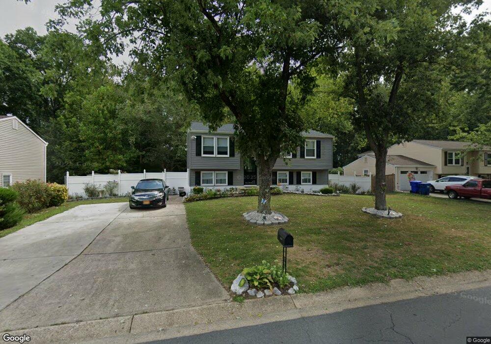
1905 Michael Rd Waldorf, MD 20601
Estimated Value: $379,033 - $398,000
--
Bed
2
Baths
996
Sq Ft
$392/Sq Ft
Est. Value
About This Home
This home is located at 1905 Michael Rd, Waldorf, MD 20601 and is currently estimated at $390,258, approximately $391 per square foot. 1905 Michael Rd is a home located in Charles County with nearby schools including J.P. Ryon Elementary School, John Hanson Middle School, and Thomas Stone High School.
Ownership History
Date
Name
Owned For
Owner Type
Purchase Details
Closed on
Jan 16, 2008
Sold by
Federal National Mortgage Association
Bought by
Briscoe Linda M
Current Estimated Value
Home Financials for this Owner
Home Financials are based on the most recent Mortgage that was taken out on this home.
Original Mortgage
$53,200
Interest Rate
6.21%
Mortgage Type
Purchase Money Mortgage
Purchase Details
Closed on
Dec 10, 2007
Sold by
Nocho Inez
Bought by
Federal National Mortgage Association
Home Financials for this Owner
Home Financials are based on the most recent Mortgage that was taken out on this home.
Original Mortgage
$53,200
Interest Rate
6.21%
Mortgage Type
Purchase Money Mortgage
Purchase Details
Closed on
Nov 28, 2007
Sold by
Federal National Mortgage Association
Bought by
Briscoe Linda M
Home Financials for this Owner
Home Financials are based on the most recent Mortgage that was taken out on this home.
Original Mortgage
$53,200
Interest Rate
6.21%
Mortgage Type
Purchase Money Mortgage
Purchase Details
Closed on
Jan 23, 2007
Sold by
Franklin Richard P
Bought by
Nocho Inez
Home Financials for this Owner
Home Financials are based on the most recent Mortgage that was taken out on this home.
Original Mortgage
$238,000
Interest Rate
9.12%
Mortgage Type
Purchase Money Mortgage
Purchase Details
Closed on
Jun 22, 2006
Sold by
Franklin Richard P
Bought by
Nocho Inez
Home Financials for this Owner
Home Financials are based on the most recent Mortgage that was taken out on this home.
Original Mortgage
$238,000
Interest Rate
9.12%
Mortgage Type
Purchase Money Mortgage
Purchase Details
Closed on
Apr 23, 2003
Sold by
Franklin Richard P and Franklin Ella L
Bought by
Franklin Richard P
Purchase Details
Closed on
May 11, 2001
Sold by
Secretary Of Housing & Urban Devel
Bought by
Franklin Richard P and Franklin Ella L
Purchase Details
Closed on
Feb 15, 2001
Sold by
Herd Wayne P and Chapman Lucy T
Bought by
Secretary Of Housing & Urban Devel
Purchase Details
Closed on
Dec 9, 1994
Sold by
Bl Goldsworth
Bought by
Herd Wayne P
Home Financials for this Owner
Home Financials are based on the most recent Mortgage that was taken out on this home.
Original Mortgage
$117,025
Interest Rate
9%
Create a Home Valuation Report for This Property
The Home Valuation Report is an in-depth analysis detailing your home's value as well as a comparison with similar homes in the area
Home Values in the Area
Average Home Value in this Area
Purchase History
| Date | Buyer | Sale Price | Title Company |
|---|---|---|---|
| Briscoe Linda M | $266,000 | -- | |
| Federal National Mortgage Association | $253,790 | -- | |
| Briscoe Linda M | $266,000 | -- | |
| Nocho Inez | $280,000 | -- | |
| Nocho Inez | $280,000 | -- | |
| Franklin Richard P | -- | -- | |
| Franklin Richard P | $110,000 | -- | |
| Secretary Of Housing & Urban Devel | $130,000 | -- | |
| Herd Wayne P | $119,987 | -- |
Source: Public Records
Mortgage History
| Date | Status | Borrower | Loan Amount |
|---|---|---|---|
| Closed | Briscoe Linda M | $53,200 | |
| Previous Owner | Briscoe Linda M | $53,200 | |
| Previous Owner | Nocho Inez | $238,000 | |
| Previous Owner | Nocho Inez | $238,000 | |
| Previous Owner | Herd Wayne P | $117,025 | |
| Closed | Franklin Richard P | -- |
Source: Public Records
Tax History Compared to Growth
Tax History
| Year | Tax Paid | Tax Assessment Tax Assessment Total Assessment is a certain percentage of the fair market value that is determined by local assessors to be the total taxable value of land and additions on the property. | Land | Improvement |
|---|---|---|---|---|
| 2025 | $8,738 | $287,367 | -- | -- |
| 2024 | $3,737 | $264,633 | $0 | $0 |
| 2023 | $3,457 | $241,900 | $83,300 | $158,600 |
| 2022 | $3,311 | $231,100 | $0 | $0 |
| 2021 | $2,981 | $220,300 | $0 | $0 |
| 2020 | $2,981 | $209,500 | $83,300 | $126,200 |
| 2019 | $2,904 | $204,867 | $0 | $0 |
| 2018 | $2,803 | $200,233 | $0 | $0 |
| 2017 | $2,735 | $195,600 | $0 | $0 |
| 2016 | -- | $192,600 | $0 | $0 |
| 2015 | $2,806 | $189,600 | $0 | $0 |
| 2014 | $2,806 | $186,600 | $0 | $0 |
Source: Public Records
Map
Nearby Homes
- 0 Pinewood Dr
- 1305 Harwich Dr
- 1325 Harwich Dr
- 5914 Michael Rd
- 9016 Holly Ave
- 1103 Falmouth Rd
- 6320 Josephine Rd
- 5026 Nicholas Rd
- 2769 Pinewood Dr
- 2419 Pinefield Rd
- 7010 Evergreen Dr
- 3907 Brewster Ct
- 919 Truro Ln
- 13246 Hawks Branch Ct
- 8311 Cedarville Rd
- 2217 Pinefield Way
- 3502 Lisa Ln
- 2730 Sprague Dr
- 3307 Peach Tree Rd
- 2650 Pinewood Dr
- 1903 Michael Rd
- 1907 Michael Rd
- 1909 Michael Rd
- 1901 Michael Rd
- 1904 Michael Rd
- 1902 Michael Rd
- 1900 Michael Rd
- 5700 Lynn Cir
- 1911 Michael Rd
- 12815 Country Ln
- 2121 Cedar Tree Ln
- 5702 Lynn Cir
- 5703 Lynn Cir
- 1913 Michael Rd
- 12809 Country Ln
- 1746 Temi Dr
- 5704 Lynn Cir
- 1915 Michael Rd
- 2125 Cedar Tree Ln
- 5705 Lynn Cir