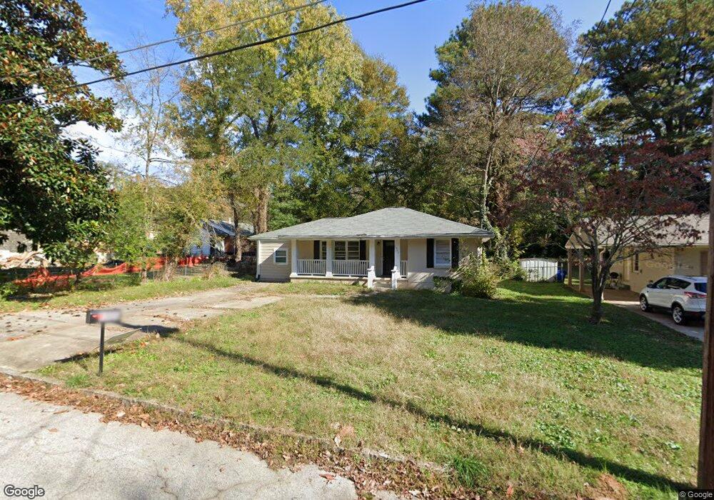
1906 Amesbury Dr Decatur, GA 30032
Estimated Value: $183,611 - $204,000
2
Beds
2
Baths
1,092
Sq Ft
$180/Sq Ft
Est. Value
About This Home
This home is located at 1906 Amesbury Dr, Decatur, GA 30032 and is currently estimated at $196,653, approximately $180 per square foot. 1906 Amesbury Dr is a home located in DeKalb County with nearby schools including Snapfinger Elementary School, Columbia Middle School, and Columbia High School.
Ownership History
Date
Name
Owned For
Owner Type
Purchase Details
Closed on
Jun 9, 2021
Sold by
Rntr 3 Llc
Bought by
Rm1 Sfr Propco A L P
Current Estimated Value
Purchase Details
Closed on
Feb 18, 2014
Sold by
Blackacre Llc
Bought by
Rntr 3 Llc
Purchase Details
Closed on
Dec 5, 2011
Sold by
Bryant Antonio
Bought by
Blackacre Llc
Purchase Details
Closed on
Oct 28, 2010
Sold by
Digangi John
Bought by
Bryant Antonio
Purchase Details
Closed on
Nov 12, 2009
Sold by
Us Bank Na Series 2004-1
Bought by
Digangi John
Purchase Details
Closed on
Sep 1, 2009
Sold by
Affordable Housing Of Atlanta
Bought by
Us Bank Na Series 2004-1
Purchase Details
Closed on
Jan 1, 2007
Sold by
Affordable Homes Of Atlanta Tr
Bought by
Flatbush Avenue Redevelopment
Purchase Details
Closed on
Feb 24, 2004
Sold by
Nurse Winston E
Bought by
Affordable Homes Of Atl Trust
Purchase Details
Closed on
Sep 4, 2001
Sold by
Huger Robert
Bought by
Kh Financial Co
Create a Home Valuation Report for This Property
The Home Valuation Report is an in-depth analysis detailing your home's value as well as a comparison with similar homes in the area
Home Values in the Area
Average Home Value in this Area
Purchase History
| Date | Buyer | Sale Price | Title Company |
|---|---|---|---|
| Rm1 Sfr Propco A L P | $5,334,391 | -- | |
| Rntr 3 Llc | $45,000 | -- | |
| Blackacre Llc | -- | -- | |
| Bryant Antonio | $37,000 | -- | |
| Digangi John | $16,900 | -- | |
| Us Bank Na Series 2004-1 | $19,430 | -- | |
| Flatbush Avenue Redevelopment | -- | -- | |
| Affordable Homes Of Atl Trust | $1,000 | -- | |
| Kh Financial Co | $55,800 | -- |
Source: Public Records
Tax History Compared to Growth
Tax History
| Year | Tax Paid | Tax Assessment Tax Assessment Total Assessment is a certain percentage of the fair market value that is determined by local assessors to be the total taxable value of land and additions on the property. | Land | Improvement |
|---|---|---|---|---|
| 2025 | $3,596 | $71,920 | $24,453 | $47,467 |
| 2024 | $3,591 | $71,920 | $24,560 | $47,360 |
| 2023 | $3,591 | $63,360 | $24,560 | $38,800 |
| 2022 | $2,627 | $52,120 | $14,040 | $38,080 |
| 2021 | $2,337 | $45,520 | $14,040 | $31,480 |
| 2020 | $2,181 | $41,960 | $12,000 | $29,960 |
| 2019 | $2,286 | $44,360 | $12,000 | $32,360 |
| 2018 | $1,421 | $29,280 | $12,000 | $17,280 |
| 2017 | $1,381 | $23,640 | $3,200 | $20,440 |
| 2016 | $1,124 | $17,760 | $3,200 | $14,560 |
| 2014 | $1,015 | $14,920 | $3,200 | $11,720 |
Source: Public Records
Map
Nearby Homes
- 1819 Rosewood Rd
- 1779 Rosewood Rd
- 3260 Glenco Dr
- 1908 S Columbia Place
- 3314 Glenco Dr
- 1870 S Columbia Place
- 1852 Shamrock Dr
- 1846 Shamrock Dr
- 1884 Derrill Dr
- 1853 Pinedale Place
- 1864 Pinedale Place
- 1879 Rosewood Rd
- 1990 Shamrock Dr
- 3235 Glenwood Rd
- 1882 Rosewood Rd
- 2361 Lynn Lris Dr
- 1857 Derrill Dr
- 1986 Bandera Dr
- 2004 Shamrock Dr
- 1906 Amesbury Dr
- 1906 Amesbury Dr
- 1910 Amesbury Dr
- 3277 Glenco Dr
- 3285 Glenco Dr
- 1916 Amesbury Dr
- 3291 Glenco Dr
- 0 Amesbury Dr Unit 7497609
- 0 Amesbury Dr Unit 7205237
- 0 Amesbury Dr Unit 3183298
- 0 Amesbury Dr Unit 8006188
- 0 Amesbury Dr Unit 8100223
- 0 Amesbury Dr Unit 2997197
- 0 Amesbury Dr
- 3267 Glenco Dr
- 1909 S Columbia Place
- 1899 S Columbia Place
- 32545 Glenco Dr
- 1799 Rosewood Rd
- 1805 Rosewood Rd