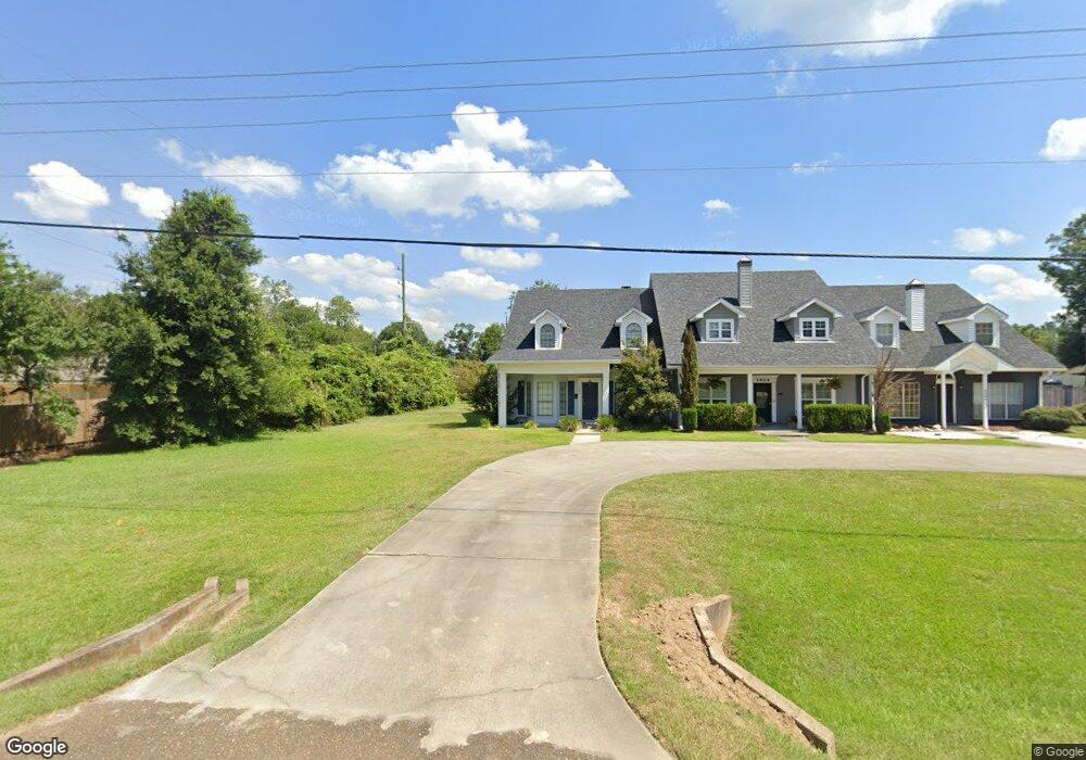
1906 Blankenship Dr Deridder, LA 70634
Estimated Value: $289,713 - $340,000
4
Beds
3
Baths
3,211
Sq Ft
$97/Sq Ft
Est. Value
About This Home
This home is located at 1906 Blankenship Dr, Deridder, LA 70634 and is currently estimated at $311,928, approximately $97 per square foot. 1906 Blankenship Dr is a home located in Beauregard Parish with nearby schools including K.R. Hanchey Elementary School, Pine Wood Elementary School, and Carver Elementary School.
Ownership History
Date
Name
Owned For
Owner Type
Purchase Details
Closed on
Jun 30, 2020
Sold by
Glass James Robert and Glass Mary Farrow
Bought by
Deridder Property Partners Llc
Current Estimated Value
Home Financials for this Owner
Home Financials are based on the most recent Mortgage that was taken out on this home.
Original Mortgage
$196,480
Outstanding Balance
$174,549
Interest Rate
3.2%
Mortgage Type
Commercial
Estimated Equity
$137,379
Create a Home Valuation Report for This Property
The Home Valuation Report is an in-depth analysis detailing your home's value as well as a comparison with similar homes in the area
Home Values in the Area
Average Home Value in this Area
Purchase History
| Date | Buyer | Sale Price | Title Company |
|---|---|---|---|
| Deridder Property Partners Llc | $240,000 | None Available |
Source: Public Records
Mortgage History
| Date | Status | Borrower | Loan Amount |
|---|---|---|---|
| Open | Deridder Property Partners Llc | $196,480 |
Source: Public Records
Tax History Compared to Growth
Tax History
| Year | Tax Paid | Tax Assessment Tax Assessment Total Assessment is a certain percentage of the fair market value that is determined by local assessors to be the total taxable value of land and additions on the property. | Land | Improvement |
|---|---|---|---|---|
| 2024 | $2,576 | $25,093 | $1,080 | $24,013 |
| 2023 | $2,269 | $21,600 | $700 | $20,900 |
| 2022 | $2,268 | $21,600 | $700 | $20,900 |
| 2021 | $2,268 | $21,600 | $700 | $20,900 |
| 2020 | $1,050 | $10,000 | $700 | $9,300 |
| 2019 | $1,051 | $10,000 | $700 | $9,300 |
| 2018 | $1,051 | $10,000 | $700 | $9,300 |
| 2017 | $1,051 | $10,000 | $700 | $9,300 |
| 2016 | $1,051 | $10,000 | $700 | $9,300 |
| 2015 | $331 | $10,000 | $600 | $9,400 |
| 2014 | $331 | $10,000 | $600 | $9,400 |
Source: Public Records
Map
Nearby Homes
- 1914 Donna Dr
- 906 Birch Dr
- 111 Henderson St
- 119 Henderson St
- 333 Dees St
- 246 Church St
- 1000 Kathleen Dr
- 147 S Planer Mill Rd
- 1015 Michael Dr
- 0 Highway 190 Unit 26-5128
- 0 Highway 190 Unit SWL24006297
- 0 Highway 190 Unit 61-162
- 2570 U S 190
- 134 P W Dr W
- 2125 U S 190
- 0 Planer Mill Rd
- 190 Blue Ridge Rd Unit Blue Ridge
- 140 Ethel Ln
- 1905 U S 190
- 115 Eddy Rd
- 1904 Blankenship Dr
- 1902 Blankenship Dr
- 311 Long St
- 308 Nolen St
- 308 Long St
- 306 Nolen St
- 1816 Blankenship Dr
- 310 Long St
- 1815 Blankenship Dr
- 306 Long St
- 309 Long St
- 309 Long St
- 104 Cecil Doyle Rd
- 0 Blankenship Dr Unit 2-607
- 0 Blankenship Dr Unit 2-159
- 0 Blankenship Dr Unit 2-5492
- 0 Blankenship Dr Unit 2-5491
- 302 Nolen St
- 2002 Blankenship Dr
- 304 Long St