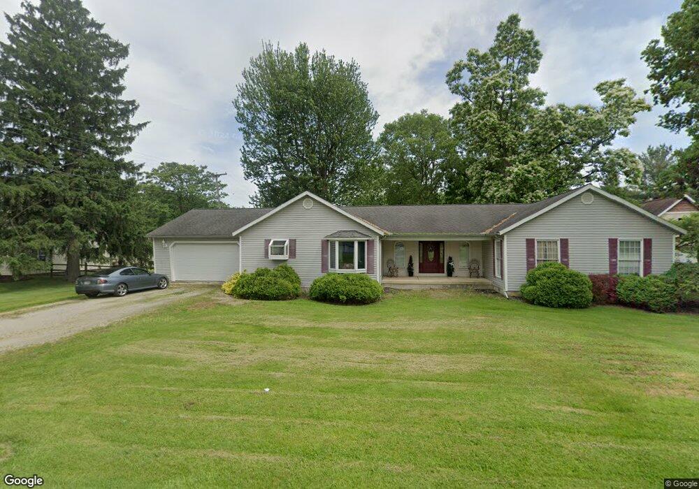
1909 Buckland Ave Fremont, OH 43420
Estimated Value: $168,000 - $326,000
3
Beds
2
Baths
2,760
Sq Ft
$94/Sq Ft
Est. Value
About This Home
This home is located at 1909 Buckland Ave, Fremont, OH 43420 and is currently estimated at $259,106, approximately $93 per square foot. 1909 Buckland Ave is a home located in Sandusky County with nearby schools including Fremont Ross High School, St. Joseph School, and Bishop Hoffman Catholic School - This is St Joe's School now.
Ownership History
Date
Name
Owned For
Owner Type
Purchase Details
Closed on
Sep 20, 1999
Sold by
Contimortgage Corp
Bought by
Davis John E and Davis Sarah C
Current Estimated Value
Home Financials for this Owner
Home Financials are based on the most recent Mortgage that was taken out on this home.
Original Mortgage
$85,141
Outstanding Balance
$25,455
Interest Rate
7.93%
Mortgage Type
FHA
Estimated Equity
$233,651
Purchase Details
Closed on
Jun 11, 1999
Sold by
Burrell Aaron A
Bought by
Contimortgage Corp
Create a Home Valuation Report for This Property
The Home Valuation Report is an in-depth analysis detailing your home's value as well as a comparison with similar homes in the area
Home Values in the Area
Average Home Value in this Area
Purchase History
| Date | Buyer | Sale Price | Title Company |
|---|---|---|---|
| Davis John E | $53,000 | -- | |
| Contimortgage Corp | $53,000 | -- |
Source: Public Records
Mortgage History
| Date | Status | Borrower | Loan Amount |
|---|---|---|---|
| Open | Davis John E | $85,141 |
Source: Public Records
Tax History Compared to Growth
Tax History
| Year | Tax Paid | Tax Assessment Tax Assessment Total Assessment is a certain percentage of the fair market value that is determined by local assessors to be the total taxable value of land and additions on the property. | Land | Improvement |
|---|---|---|---|---|
| 2024 | $2,980 | $86,490 | $9,980 | $76,510 |
| 2023 | $2,980 | $73,920 | $8,540 | $65,380 |
| 2022 | $2,705 | $73,920 | $8,540 | $65,380 |
| 2021 | $2,787 | $73,920 | $8,540 | $65,380 |
| 2020 | $3,059 | $68,570 | $8,540 | $60,030 |
| 2019 | $3,056 | $68,570 | $8,540 | $60,030 |
| 2018 | $2,976 | $68,570 | $8,540 | $60,030 |
| 2017 | $2,650 | $60,730 | $8,540 | $52,190 |
| 2016 | $2,330 | $60,730 | $8,540 | $52,190 |
| 2015 | $2,294 | $60,730 | $8,540 | $52,190 |
| 2014 | $2,161 | $54,780 | $8,370 | $46,410 |
| 2013 | $2,116 | $54,780 | $8,370 | $46,410 |
Source: Public Records
Map
Nearby Homes
- 1719 Buckland Ave
- 1485 Autumn Woods Dr
- 2484 Buckland Ave
- 1420 Center St
- 10 Meadowbrook Dr
- 10 Meadowbrook Ln
- 64 River Run Dr Unit J
- 1611 Mcpherson Blvd
- 1028 June St
- 1013 Whittlesey St
- 905 Twinn St
- 1015 Hayes Ave
- 135 Briarwood Cir
- 1037 Buckland Ave
- 815 South St
- 616 S Wood St
- 625 Bush Place
- 1818 Finley Dr
- 515 Everett Rd
- 619 Hayes Ave
- 1917 Buckland Ave
- 1901 Buckland Ave
- 1016 Oakwood St
- 1902 Buckland Ave
- 1022 Oakwood St
- 952 Fennimore St
- 1829 Buckland Ave
- 1921 Buckland Ave
- 1828 Buckland Ave
- 1946 Buckland Ave
- 1028 Oakwood St
- 1028 Oakwood St
- 934 Fennimore St
- 1954 Buckland Ave
- 1822 Buckland Ave
- 1036 Oakwood St
- 901 Fennimore St
- 906 Fennimore St
- 1943 Martin Ave
- 1968 Buckland Ave