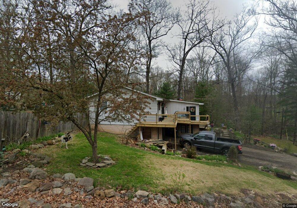
1909 Maple Dr Zanesville, OH 43701
Estimated Value: $246,000 - $284,000
3
Beds
2
Baths
1,532
Sq Ft
$172/Sq Ft
Est. Value
About This Home
This home is located at 1909 Maple Dr, Zanesville, OH 43701 and is currently estimated at $263,900, approximately $172 per square foot. 1909 Maple Dr is a home located in Muskingum County with nearby schools including Maysville Elementary School, Maysville Middle School, and Maysville High School.
Ownership History
Date
Name
Owned For
Owner Type
Purchase Details
Closed on
Apr 6, 1999
Sold by
American General Finance
Bought by
Mckee Wililam L and Mckee Kelley K
Current Estimated Value
Home Financials for this Owner
Home Financials are based on the most recent Mortgage that was taken out on this home.
Original Mortgage
$82,311
Outstanding Balance
$20,583
Interest Rate
6.89%
Mortgage Type
FHA
Estimated Equity
$243,317
Purchase Details
Closed on
Nov 6, 1998
Sold by
Strock Kelly L
Bought by
American General Finance
Purchase Details
Closed on
Apr 26, 1995
Sold by
Miller Timothy K
Bought by
Strock John and Strock Kelly
Home Financials for this Owner
Home Financials are based on the most recent Mortgage that was taken out on this home.
Original Mortgage
$66,048
Interest Rate
8.42%
Mortgage Type
New Conventional
Create a Home Valuation Report for This Property
The Home Valuation Report is an in-depth analysis detailing your home's value as well as a comparison with similar homes in the area
Home Values in the Area
Average Home Value in this Area
Purchase History
| Date | Buyer | Sale Price | Title Company |
|---|---|---|---|
| Mckee Wililam L | $82,400 | -- | |
| American General Finance | $42,000 | -- | |
| Strock John | $79,500 | -- |
Source: Public Records
Mortgage History
| Date | Status | Borrower | Loan Amount |
|---|---|---|---|
| Open | Mckee Wililam L | $82,311 | |
| Previous Owner | Strock John | $66,048 |
Source: Public Records
Tax History Compared to Growth
Tax History
| Year | Tax Paid | Tax Assessment Tax Assessment Total Assessment is a certain percentage of the fair market value that is determined by local assessors to be the total taxable value of land and additions on the property. | Land | Improvement |
|---|---|---|---|---|
| 2024 | $2,235 | $70,560 | $11,410 | $59,150 |
| 2023 | $1,432 | $41,755 | $6,580 | $35,175 |
| 2022 | $1,395 | $41,755 | $6,580 | $35,175 |
| 2021 | $1,373 | $41,755 | $6,580 | $35,175 |
| 2020 | $1,219 | $34,790 | $5,495 | $29,295 |
| 2019 | $1,205 | $34,790 | $5,495 | $29,295 |
| 2018 | $1,197 | $34,790 | $5,495 | $29,295 |
| 2017 | $1,192 | $32,130 | $5,495 | $26,635 |
| 2016 | $1,146 | $32,140 | $5,500 | $26,640 |
| 2015 | $1,169 | $32,140 | $5,500 | $26,640 |
| 2013 | $1,251 | $32,140 | $5,500 | $26,640 |
Source: Public Records
Map
Nearby Homes
- 108 Summit Dr
- 109 Sherwood Dr
- 1119 Ellen Dr
- 1705 Bradford Ave
- 108 N Montague Ave
- 2854 Mcfarland Dr
- 1321 S Westwood Dr
- 2945 Shaw Rd
- 2631 Coopermill Rd
- 1049 Benjamin Ave
- 72 N Pembroke Ave
- 2810 Maysville Pike
- 2625 Fawn Ln
- 67 E King St
- 3208 Lakewood Dr
- 72 E Berkley St
- 16 Beech Rock Dr
- 911 Merrick Ave
- 1140 Lindbergh Ave
- 105 Rains Cir