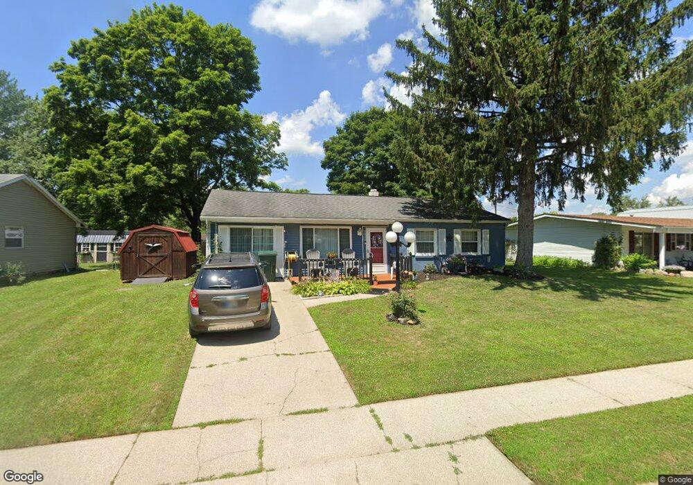
1909 S Phillip Dr Muncie, IN 47302
Forest Park NeighborhoodEstimated Value: $95,000 - $126,915
3
Beds
1
Bath
1,305
Sq Ft
$87/Sq Ft
Est. Value
About This Home
This home is located at 1909 S Phillip Dr, Muncie, IN 47302 and is currently estimated at $113,729, approximately $87 per square foot. 1909 S Phillip Dr is a home located in Delaware County with nearby schools including West View Elementary School, Muncie Central High School, and Southside Middle School.
Ownership History
Date
Name
Owned For
Owner Type
Purchase Details
Closed on
Sep 15, 2017
Sold by
Weaver Joyce A
Bought by
Weaver Sherry L
Current Estimated Value
Home Financials for this Owner
Home Financials are based on the most recent Mortgage that was taken out on this home.
Original Mortgage
$25,000
Interest Rate
3.89%
Mortgage Type
New Conventional
Create a Home Valuation Report for This Property
The Home Valuation Report is an in-depth analysis detailing your home's value as well as a comparison with similar homes in the area
Home Values in the Area
Average Home Value in this Area
Purchase History
| Date | Buyer | Sale Price | Title Company |
|---|---|---|---|
| Weaver Sherry L | -- | -- |
Source: Public Records
Mortgage History
| Date | Status | Borrower | Loan Amount |
|---|---|---|---|
| Closed | Weaver Sherry L | $25,000 |
Source: Public Records
Tax History
| Year | Tax Paid | Tax Assessment Tax Assessment Total Assessment is a certain percentage of the fair market value that is determined by local assessors to be the total taxable value of land and additions on the property. | Land | Improvement |
|---|---|---|---|---|
| 2025 | $707 | $108,700 | $12,600 | $96,100 |
| 2024 | $707 | $87,600 | $12,600 | $75,000 |
| 2023 | $720 | $89,700 | $12,600 | $77,100 |
| 2022 | $483 | $80,600 | $12,600 | $68,000 |
| 2021 | $257 | $68,900 | $10,100 | $58,800 |
| 2020 | $118 | $54,000 | $10,100 | $43,900 |
| 2019 | $118 | $54,000 | $10,100 | $43,900 |
| 2018 | $118 | $53,000 | $10,100 | $42,900 |
| 2017 | $617 | $52,700 | $9,400 | $43,300 |
| 2016 | $632 | $52,700 | $9,400 | $43,300 |
| 2014 | $531 | $52,600 | $8,900 | $43,700 |
| 2013 | -- | $52,700 | $9,500 | $43,200 |
Source: Public Records
Map
Nearby Homes
- 2031 S Daly Ave
- 2025 S Lazy Creek Dr
- 2520 W 11th St
- 2519 W 10th St
- 1601 S Clark St
- 2200 W Memorial Dr
- 2300 W 9th St
- 2233 W 8th St
- 1808 W 11th St
- 1605 W Memorial Dr
- 1617 W 16th St
- 1504 W 13th St
- 1448 W 14th St
- 610 S Manning Ave
- 2417 S Hoyt Ave
- 2224 S Hoyt Ave
- 2707 W 26th St
- 3515 W Godman Ave
- 422 S Hutchinson Ave
- 512 S Talley Ave
- 2001 S Phillip Dr
- 1907 S Phillip Dr
- 1908 S Victoria Dr
- 1906 S Victoria Dr
- 2000 S Victoria Dr
- 2701 W Brookfield Dr
- 1910 S Phillip Dr
- 2705 W Brookfield Dr
- 1908 S Phillip Dr
- 2000 S Phillip Dr
- 2002 S Victoria Dr
- 2709 W Brookfield Dr
- 1906 S Phillip Dr
- 2005 S Phillip Dr
- 2002 S Phillip Dr
- 1904 S Phillips Dr
- 2004 S Victoria Dr
- 1904 S Phillip Dr
- 2007 S Clark St
- 2007 S Clark St Unit Muncie
Your Personal Tour Guide
Ask me questions while you tour the home.