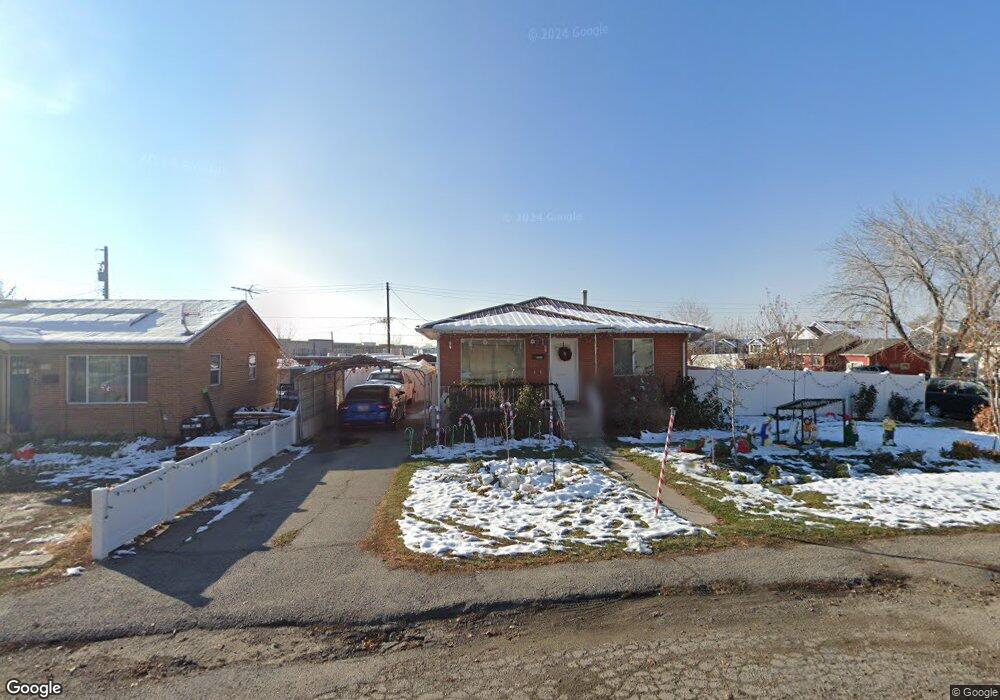
191 Allenhurst Pleasant Grove, UT 84062
Estimated Value: $382,000 - $444,000
3
Beds
1
Bath
952
Sq Ft
$442/Sq Ft
Est. Value
About This Home
This home is located at 191 Allenhurst, Pleasant Grove, UT 84062 and is currently estimated at $420,702, approximately $441 per square foot. 191 Allenhurst is a home located in Utah County with nearby schools including Central Elementary School, Pleasant Grove Junior High School, and Pleasant Grove High School.
Ownership History
Date
Name
Owned For
Owner Type
Purchase Details
Closed on
Jun 26, 2007
Sold by
Frampton Dustin R and Millward Jennifer
Bought by
Davis Michael T and Davis Maurina J
Current Estimated Value
Purchase Details
Closed on
Dec 23, 2003
Sold by
Bezzant Russell and Bezzant Melissa
Bought by
Frampton Dustin R and Millward Jennifer
Home Financials for this Owner
Home Financials are based on the most recent Mortgage that was taken out on this home.
Original Mortgage
$121,985
Interest Rate
6.03%
Mortgage Type
FHA
Purchase Details
Closed on
Jun 27, 2000
Sold by
Jones George T and Jones Yvonne V
Bought by
Bezzant Russell and Bezzant Melissa
Home Financials for this Owner
Home Financials are based on the most recent Mortgage that was taken out on this home.
Original Mortgage
$104,000
Interest Rate
8.67%
Mortgage Type
Seller Take Back
Create a Home Valuation Report for This Property
The Home Valuation Report is an in-depth analysis detailing your home's value as well as a comparison with similar homes in the area
Home Values in the Area
Average Home Value in this Area
Purchase History
| Date | Buyer | Sale Price | Title Company |
|---|---|---|---|
| Davis Michael T | -- | Union Title | |
| Frampton Dustin R | -- | Equity Title Agency Inc | |
| Bezzant Russell | -- | Mountain West Title Co |
Source: Public Records
Mortgage History
| Date | Status | Borrower | Loan Amount |
|---|---|---|---|
| Previous Owner | Frampton Dustin R | $121,985 | |
| Previous Owner | Bezzant Russell | $104,000 |
Source: Public Records
Tax History Compared to Growth
Tax History
| Year | Tax Paid | Tax Assessment Tax Assessment Total Assessment is a certain percentage of the fair market value that is determined by local assessors to be the total taxable value of land and additions on the property. | Land | Improvement |
|---|---|---|---|---|
| 2025 | $1,629 | $209,880 | $193,900 | $187,700 |
| 2024 | $1,629 | $194,370 | $0 | $0 |
| 2023 | $1,581 | $193,160 | $0 | $0 |
| 2022 | $1,798 | $218,625 | $0 | $0 |
| 2021 | $1,551 | $287,100 | $139,100 | $148,000 |
| 2020 | $1,426 | $258,700 | $124,200 | $134,500 |
| 2019 | $1,241 | $232,800 | $114,200 | $118,600 |
| 2018 | $1,177 | $208,800 | $103,600 | $105,200 |
| 2017 | $1,047 | $98,945 | $0 | $0 |
| 2016 | $1,042 | $94,985 | $0 | $0 |
| 2015 | $1,100 | $94,985 | $0 | $0 |
| 2014 | $1,014 | $86,790 | $0 | $0 |
Source: Public Records
Map
Nearby Homes
- 264 W State St Unit 18
- 169 W 200 S
- 165 S Pleasant Blvd Unit 45
- 405 N 200 E
- 146 N 200 E
- 278 S 740 W
- 190 E 200 S
- 165 S 200 E
- 383 S 790 W
- 1078 W 70 N
- 123 N Romney Ln Unit 103
- 289 S 1000 W Unit 203
- 317 S 1000 W Unit 104
- 1130 W State Rd
- 685 W 1000 N
- 380 S 300 E
- 165 E 500 S
- 854 N 1010 W
- 1249 W Cambria Dr Unit 101
- 1267 W 20 S