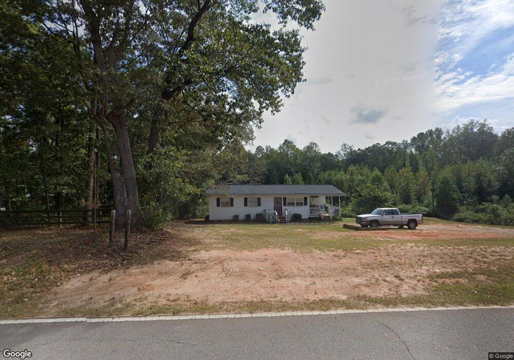
191 Beaverpond Rd Carrollton, GA 30117
Estimated Value: $152,653 - $236,000
2
Beds
1
Bath
945
Sq Ft
$215/Sq Ft
Est. Value
About This Home
This home is located at 191 Beaverpond Rd, Carrollton, GA 30117 and is currently estimated at $202,913, approximately $214 per square foot. 191 Beaverpond Rd is a home located in Carroll County with nearby schools including Mt. Zion Elementary School, Mt. Zion Middle School, and Mt. Zion High School.
Ownership History
Date
Name
Owned For
Owner Type
Purchase Details
Closed on
Jul 7, 2023
Sold by
George Gregory L
Bought by
George Mckinley and Mckinley Wynter
Current Estimated Value
Purchase Details
Closed on
Jul 6, 1999
Sold by
George Gregory L
Bought by
George Gregory L
Purchase Details
Closed on
Sep 12, 1998
Sold by
Bagwell Bill and Bagwell Geo G
Bought by
George Gregory L
Purchase Details
Closed on
Aug 21, 1998
Bought by
Bagwell Bill and Bagwell Geo G
Create a Home Valuation Report for This Property
The Home Valuation Report is an in-depth analysis detailing your home's value as well as a comparison with similar homes in the area
Home Values in the Area
Average Home Value in this Area
Purchase History
| Date | Buyer | Sale Price | Title Company |
|---|---|---|---|
| George Mckinley | -- | -- | |
| George Mckinley | -- | -- | |
| George Gregory L | -- | -- | |
| George Gregory L | $20,200 | -- | |
| Bagwell Bill | -- | -- |
Source: Public Records
Tax History Compared to Growth
Tax History
| Year | Tax Paid | Tax Assessment Tax Assessment Total Assessment is a certain percentage of the fair market value that is determined by local assessors to be the total taxable value of land and additions on the property. | Land | Improvement |
|---|---|---|---|---|
| 2024 | $626 | $27,653 | $6,344 | $21,309 |
| 2023 | $626 | $24,498 | $5,076 | $19,422 |
| 2022 | $476 | $18,968 | $3,384 | $15,584 |
| 2021 | $412 | $16,088 | $2,707 | $13,381 |
| 2020 | $369 | $14,368 | $2,461 | $11,907 |
| 2019 | $353 | $13,622 | $2,461 | $11,161 |
| 2018 | $339 | $12,928 | $2,300 | $10,628 |
| 2017 | $341 | $12,928 | $2,300 | $10,628 |
| 2016 | $341 | $12,928 | $2,300 | $10,628 |
| 2015 | $420 | $15,013 | $2,318 | $12,695 |
| 2014 | $422 | $15,013 | $2,318 | $12,695 |
Source: Public Records
Map
Nearby Homes
- 2994 Mount Zion Rd
- 2994 Mount Zion Rd Unit 1
- 2994 Mount Zion Rd Unit 3
- 33 Armstrong Dr
- 30 Joshua Way
- 10 Joshua Way
- 46 Gammon Rd
- 85 Eureka Church Rd Unit 152
- 1202 Mount Zion Rd
- 304 Kodiak Rd
- 113 Natures Pointe Trail
- 778 Harrison Rd
- 113 Richmond Dr
- 266 Lambert Overlook Cir
- The Thomas 2 Plan at Lambert Overlook
- The Thomas Plan at Lambert Overlook
- The Brook Plan at Lambert Overlook
- 206 Randall Dr
- 141 Anita Blvd
- 153 Anita Blvd
- 178 Beaverpond Rd
- 145 Beaverpond Rd
- 129 Beaverpond Rd
- 150 Beaverpond Rd
- 162 Beaverpond Rd
- 210 Beaverpond Rd
- 255 Beaverpond Rd
- 121 Beaverpond Rd
- 120 Beaverpond Rd
- 285 Beaverpond Rd
- 117 Beaverpond Rd
- 115 Beaverpond Rd
- 81 Beaverpond Rd
- 0 Tiffany Ln
- 17 Tiffany Ln
- 76 Beaverpond Rd
- 75 Beaverpond Rd
- 36 Beaverpond Rd
- 3079 Mount Zion Rd
- 3035 Mount Zion Rd