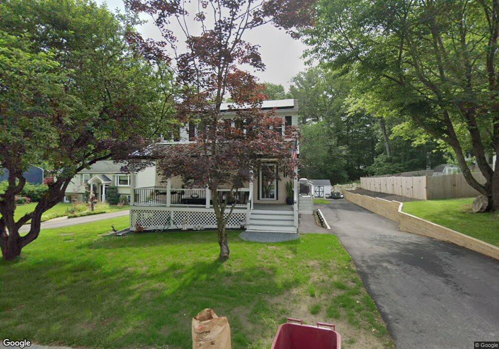
191 Freda Ln Lowell, MA 01854
Pawtucketville NeighborhoodEstimated Value: $581,000 - $724,000
3
Beds
2
Baths
1,900
Sq Ft
$345/Sq Ft
Est. Value
About This Home
This home is located at 191 Freda Ln, Lowell, MA 01854 and is currently estimated at $655,724, approximately $345 per square foot. 191 Freda Ln is a home located in Middlesex County with nearby schools including Joseph McAvinnue Elementary School, Charles W. Morey Elementary School, and Charlotte M. Murkland Elementary School.
Ownership History
Date
Name
Owned For
Owner Type
Purchase Details
Closed on
Oct 28, 1998
Sold by
Beaudoin Richard M and Beaudoin Kim M
Bought by
Marshall Steven M and Marshall Wanda M
Current Estimated Value
Purchase Details
Closed on
Jul 2, 1996
Sold by
Siney Mark R and Siney Virginia
Bought by
Beaudoin Richard M and Beaudoin Kim
Purchase Details
Closed on
Feb 9, 1990
Sold by
Mccracken David
Bought by
Siney Mark
Create a Home Valuation Report for This Property
The Home Valuation Report is an in-depth analysis detailing your home's value as well as a comparison with similar homes in the area
Home Values in the Area
Average Home Value in this Area
Purchase History
| Date | Buyer | Sale Price | Title Company |
|---|---|---|---|
| Marshall Steven M | $150,000 | -- | |
| Marshall Steven M | $150,000 | -- | |
| Beaudoin Richard M | $128,000 | -- | |
| Beaudoin Richard M | $128,000 | -- | |
| Siney Mark | $138,000 | -- | |
| Siney Mark | $138,000 | -- |
Source: Public Records
Mortgage History
| Date | Status | Borrower | Loan Amount |
|---|---|---|---|
| Open | Siney Mark | $184,000 | |
| Closed | Siney Mark | $18,000 |
Source: Public Records
Tax History
| Year | Tax Paid | Tax Assessment Tax Assessment Total Assessment is a certain percentage of the fair market value that is determined by local assessors to be the total taxable value of land and additions on the property. | Land | Improvement |
|---|---|---|---|---|
| 2025 | $6,533 | $569,100 | $180,800 | $388,300 |
| 2024 | $5,224 | $438,600 | $168,900 | $269,700 |
| 2023 | $4,920 | $396,100 | $146,900 | $249,200 |
| 2022 | $4,416 | $348,000 | $133,500 | $214,500 |
| 2021 | $4,125 | $306,500 | $116,100 | $190,400 |
| 2020 | $4,020 | $300,900 | $118,500 | $182,400 |
| 2019 | $3,885 | $276,700 | $104,300 | $172,400 |
| 2018 | $3,852 | $267,700 | $99,300 | $168,400 |
| 2017 | $3,717 | $249,100 | $90,300 | $158,800 |
| 2016 | $3,760 | $248,000 | $84,300 | $163,700 |
| 2015 | $3,548 | $229,200 | $82,500 | $146,700 |
| 2013 | $3,587 | $239,000 | $103,700 | $135,300 |
Source: Public Records
Map
Nearby Homes
- 1461 Pawtucket Blvd Unit 12
- 1401 Pawtucket Blvd Unit 10
- 1401 Pawtucket Blvd Unit 2
- 152 Wellman Ave Unit 152
- 139 Wellman Ave Unit 139
- 20 Sandy Ln
- 262 Wellman Ave Unit 262
- 251 Wellman Ave Unit 251
- 1215 Pawtucket Blvd Unit 19
- 331 Wellman Ave
- 3 Louis Farm Rd Unit 3
- 10 Butterfield St
- 248 Acropolis Rd
- 16 Middlesex St Unit 4
- 1 Hope St
- 180 Tyngsboro Rd Unit 17
- 29 Middlesex St Unit 1
- 4 Wood St
- 5 Mission Rd Unit 107
- 27 Tyng Rd
Your Personal Tour Guide
Ask me questions while you tour the home.