Estimated Value: $865,000 - $957,000
3
Beds
3
Baths
2,160
Sq Ft
$418/Sq Ft
Est. Value
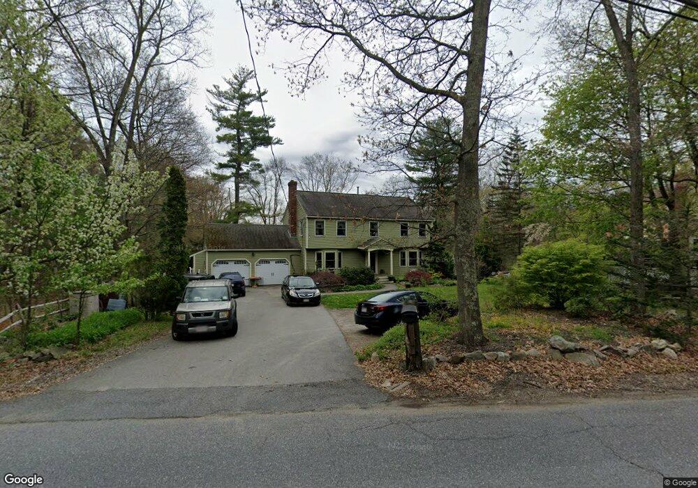
About This Home
This home is located at 191 High St, Acton, MA 01720 and is currently estimated at $902,409, approximately $417 per square foot. 191 High St is a home located in Middlesex County with nearby schools including Acton-Boxborough Regional High School, Maynard Knowledge Beginnings, and The Imago School.
Ownership History
Date
Name
Owned For
Owner Type
Purchase Details
Closed on
Apr 17, 2024
Sold by
Hobkirk Kathleen G
Bought by
Kathleen G Hobkirk T G and Kathleen Hobkirk
Current Estimated Value
Purchase Details
Closed on
Dec 3, 1990
Sold by
Harrington Joseph R
Bought by
Tucker Marian
Home Financials for this Owner
Home Financials are based on the most recent Mortgage that was taken out on this home.
Original Mortgage
$125,000
Interest Rate
10.16%
Mortgage Type
Purchase Money Mortgage
Purchase Details
Closed on
Mar 7, 1988
Sold by
Lafrance Edmond P
Bought by
Joseph R Harrington 3D
Home Financials for this Owner
Home Financials are based on the most recent Mortgage that was taken out on this home.
Original Mortgage
$200,000
Interest Rate
10.35%
Mortgage Type
Purchase Money Mortgage
Create a Home Valuation Report for This Property
The Home Valuation Report is an in-depth analysis detailing your home's value as well as a comparison with similar homes in the area
Home Values in the Area
Average Home Value in this Area
Purchase History
| Date | Buyer | Sale Price | Title Company |
|---|---|---|---|
| Kathleen G Hobkirk T G | -- | None Available | |
| Hobkirk Kathleen G | -- | None Available | |
| Kathleen G Hobkirk T G | -- | None Available | |
| Hobkirk Kathleen G | -- | None Available | |
| Tucker Marian | $225,000 | -- | |
| Tucker Marian | $225,000 | -- | |
| Joseph R Harrington 3D | $125,000 | -- |
Source: Public Records
Mortgage History
| Date | Status | Borrower | Loan Amount |
|---|---|---|---|
| Previous Owner | Joseph R Harrington 3D | $125,000 | |
| Previous Owner | Joseph R Harrington 3D | $200,000 |
Source: Public Records
Tax History
| Year | Tax Paid | Tax Assessment Tax Assessment Total Assessment is a certain percentage of the fair market value that is determined by local assessors to be the total taxable value of land and additions on the property. | Land | Improvement |
|---|---|---|---|---|
| 2025 | $13,605 | $793,300 | $319,000 | $474,300 |
| 2024 | $12,729 | $763,600 | $319,000 | $444,600 |
| 2023 | $12,712 | $723,900 | $290,000 | $433,900 |
| 2022 | $12,028 | $618,400 | $252,200 | $366,200 |
| 2021 | $11,744 | $580,500 | $233,600 | $346,900 |
| 2020 | $11,076 | $575,700 | $233,600 | $342,100 |
| 2019 | $10,735 | $554,200 | $233,600 | $320,600 |
| 2018 | $10,547 | $544,200 | $233,600 | $310,600 |
| 2017 | $10,277 | $539,200 | $233,600 | $305,600 |
| 2016 | $10,078 | $524,100 | $233,600 | $290,500 |
| 2015 | $9,948 | $522,200 | $233,600 | $288,600 |
| 2014 | $9,614 | $494,300 | $233,600 | $260,700 |
Source: Public Records
Map
Nearby Homes
- 1 Drummer Rd Unit A5
- 128 Parker St Unit 3B
- 31 Drummer Rd Unit 31
- 30 Brewster Ln
- 63 Conant St
- 1 Vanderbelt Rd
- 40 High St
- 7 Hillcrest Dr
- 70 River St
- 36 Brown St
- 70 Powder Mill Rd
- 68 Powder Mill Rd
- 66 Powder Mill Rd
- 96 Forest Ridge Rd Unit 96
- 12 Brown St
- 23 Deer Path Unit 5
- 129 Main St Unit 129
- 131 Main St
- 25 Nylander Way
- 22 Douglas Ave Unit 2
Your Personal Tour Guide
Ask me questions while you tour the home.