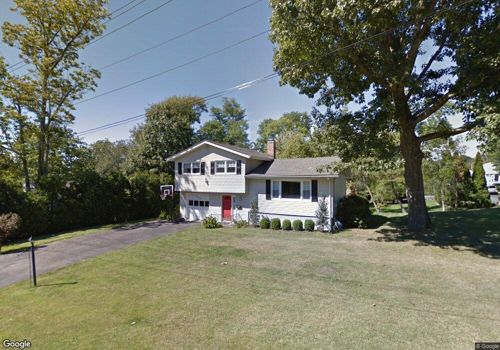
191 Manhattan Ave Hawthorne, NY 10532
Estimated Value: $732,000 - $809,000
3
Beds
2
Baths
1,750
Sq Ft
$437/Sq Ft
Est. Value
About This Home
This home is located at 191 Manhattan Ave, Hawthorne, NY 10532 and is currently estimated at $763,956, approximately $436 per square foot. 191 Manhattan Ave is a home located in Westchester County with nearby schools including Hawthorne Elementary School, Columbus Elementary School, and Westlake Middle School.
Ownership History
Date
Name
Owned For
Owner Type
Purchase Details
Closed on
May 26, 2016
Sold by
Ruland Connie
Bought by
Callan Eugene M and Callan Maria Pia
Current Estimated Value
Purchase Details
Closed on
May 26, 2011
Sold by
Mellor Robert G and Mellor Evelyn M
Bought by
Hawkins John C and Hawkins Lisa
Home Financials for this Owner
Home Financials are based on the most recent Mortgage that was taken out on this home.
Original Mortgage
$348,000
Interest Rate
4.58%
Mortgage Type
New Conventional
Create a Home Valuation Report for This Property
The Home Valuation Report is an in-depth analysis detailing your home's value as well as a comparison with similar homes in the area
Home Values in the Area
Average Home Value in this Area
Purchase History
| Date | Buyer | Sale Price | Title Company |
|---|---|---|---|
| Callan Eugene M | $470,000 | Rjf Title Agency Llc | |
| Hawkins John C | $435,000 | Chicago Title Insurance Co |
Source: Public Records
Mortgage History
| Date | Status | Borrower | Loan Amount |
|---|---|---|---|
| Previous Owner | Hawkins John C | $348,000 |
Source: Public Records
Tax History Compared to Growth
Tax History
| Year | Tax Paid | Tax Assessment Tax Assessment Total Assessment is a certain percentage of the fair market value that is determined by local assessors to be the total taxable value of land and additions on the property. | Land | Improvement |
|---|---|---|---|---|
| 2024 | $13,573 | $6,200 | $1,000 | $5,200 |
| 2023 | $13,316 | $6,200 | $1,000 | $5,200 |
| 2022 | $13,142 | $6,200 | $1,000 | $5,200 |
| 2021 | $12,913 | $6,200 | $1,000 | $5,200 |
| 2020 | $11,122 | $6,200 | $1,000 | $5,200 |
| 2019 | $12,357 | $6,200 | $1,000 | $5,200 |
| 2018 | $12,982 | $6,200 | $1,000 | $5,200 |
| 2017 | $3,718 | $6,200 | $1,000 | $5,200 |
| 2016 | $11,120 | $6,200 | $1,000 | $5,200 |
| 2015 | -- | $6,200 | $1,000 | $5,200 |
| 2014 | -- | $6,200 | $1,000 | $5,200 |
| 2013 | -- | $6,200 | $1,000 | $5,200 |
Source: Public Records
Map
Nearby Homes
- 237 Brady Ave
- 233 Brady Ave
- 32 Weed Ave
- 317 Elwood Ave
- 350 Commerce St
- 404 Manhattan Ave
- 16 Highclere Ln Unit A
- 14 Aspen Way
- 116 Rolling Hills Rd
- 00 Belleview Ave
- 324 Tuxedo Place
- 7 Fountain Dr
- 66 Leroy Ave
- 179A Lakeview Ave
- 1 Eunice Ln
- 24 Burnsdale Ave
- Lot 92 Columbus Ave
- 3 Rolling Hills Rd
- 14 Halsey Place
- 140 Columbus Ave
- 197 Manhattan Ave
- 190 Willis Ave
- 183 Manhattan Ave
- 192 Manhattan Ave
- 196 Willis Ave
- 194 Manhattan Ave
- 180 Willis Ave
- 179 Manhattan Ave
- 199 Manhattan Ave
- 196 Manhattan Ave
- 182 Manhattan Ave
- 198 Willis Ave
- 198 Manhattan Ave
- 176 Willis Ave
- 193 Sherman Ave
- 191 Willis Ave
- 180 Manhattan Ave
- 197 Sherman Ave
- 197 Willis Ave
- 200 Manhattan Ave