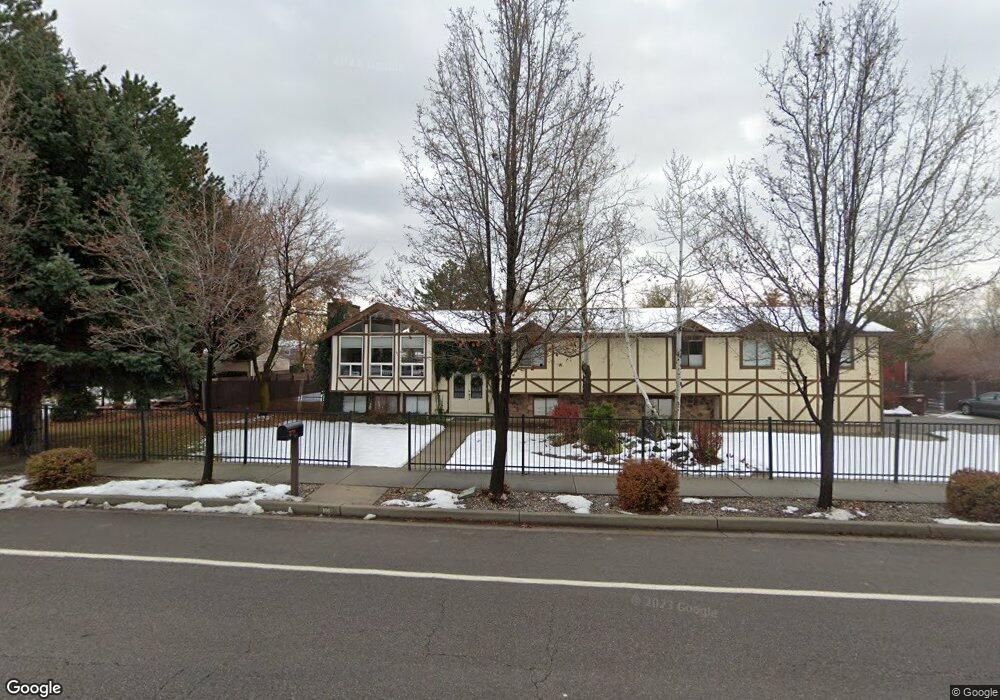
191 W 200 N Alpine, UT 84004
Estimated Value: $632,000 - $804,000
4
Beds
2
Baths
2,382
Sq Ft
$306/Sq Ft
Est. Value
About This Home
This home is located at 191 W 200 N, Alpine, UT 84004 and is currently estimated at $728,644, approximately $305 per square foot. 191 W 200 N is a home located in Utah County with nearby schools including Westfield School, Timberline Middle School, and Lone Peak High School.
Ownership History
Date
Name
Owned For
Owner Type
Purchase Details
Closed on
Aug 29, 2024
Sold by
Smith Scott E and Smith Heather G
Bought by
Heather G Smith And Scott E Smith Revocable T and Smith
Current Estimated Value
Purchase Details
Closed on
Feb 8, 2012
Sold by
Smith Scott E and Smith Heatherlyn G
Bought by
Smith Scott E and Smith Heather G
Home Financials for this Owner
Home Financials are based on the most recent Mortgage that was taken out on this home.
Original Mortgage
$215,819
Interest Rate
3.9%
Mortgage Type
New Conventional
Purchase Details
Closed on
Nov 16, 2000
Sold by
Forsyth James B and Anderson Kathy L
Bought by
Smith Scott E and Smith Heatherlyn G
Home Financials for this Owner
Home Financials are based on the most recent Mortgage that was taken out on this home.
Original Mortgage
$149,500
Interest Rate
7.86%
Create a Home Valuation Report for This Property
The Home Valuation Report is an in-depth analysis detailing your home's value as well as a comparison with similar homes in the area
Home Values in the Area
Average Home Value in this Area
Purchase History
| Date | Buyer | Sale Price | Title Company |
|---|---|---|---|
| Heather G Smith And Scott E Smith Revocable T | -- | Meridian Title | |
| Smith Scott E | -- | Meridian Title Company | |
| Smith Scott E | -- | Signature Title |
Source: Public Records
Mortgage History
| Date | Status | Borrower | Loan Amount |
|---|---|---|---|
| Previous Owner | Smith Scott E | $215,819 | |
| Previous Owner | Smith Scott E | $149,500 | |
| Closed | Smith Scott E | $25,000 |
Source: Public Records
Tax History Compared to Growth
Tax History
| Year | Tax Paid | Tax Assessment Tax Assessment Total Assessment is a certain percentage of the fair market value that is determined by local assessors to be the total taxable value of land and additions on the property. | Land | Improvement |
|---|---|---|---|---|
| 2025 | $3,108 | $376,420 | $455,000 | $229,400 |
| 2024 | $3,108 | $362,285 | $0 | $0 |
| 2023 | $2,865 | $358,490 | $0 | $0 |
| 2022 | $2,893 | $351,615 | $0 | $0 |
| 2021 | $2,262 | $427,000 | $242,900 | $184,100 |
| 2020 | $2,092 | $386,500 | $211,200 | $175,300 |
| 2019 | $1,885 | $363,600 | $211,200 | $152,400 |
| 2018 | $1,838 | $350,200 | $202,800 | $147,400 |
| 2017 | $1,749 | $177,375 | $0 | $0 |
| 2016 | $1,713 | $161,975 | $0 | $0 |
| 2015 | $1,673 | $149,655 | $0 | $0 |
| 2014 | $1,534 | $135,740 | $0 | $0 |
Source: Public Records
Map
Nearby Homes
- 30 S Main St
- 48 N 100 E
- 501 W Devey Dr
- 259 Twin River Loop
- 177 W Canyon Crest Rd
- 250 S Main St Unit 7
- 250 S Main St Unit 20
- 250 S Main St Unit 25
- 35 Sledhill Cir Unit 2
- 201 E Red Pine Dr Unit 17
- 475 Grove Dr
- 659 E Pioneer Rd
- 1249 E Pioneer Rd
- 443 Lupine Dr Unit 7
- 760 Eagleview Dr
- 820 Eagleview Dr
- 88 W Cascade Ave
- 546 River Meadow Dr
- 522 N Pfeifferhorn Dr
- 591 N Pfeifferhorn Dr