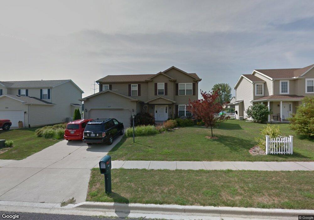
1910 Colt Dr Washington, IL 61571
Estimated Value: $322,000 - $367,000
4
Beds
4
Baths
2,088
Sq Ft
$163/Sq Ft
Est. Value
About This Home
This home is located at 1910 Colt Dr, Washington, IL 61571 and is currently estimated at $339,517, approximately $162 per square foot. 1910 Colt Dr is a home located in Tazewell County with nearby schools including Central Primary School, Central Intermediate School, and Washington Community High School.
Ownership History
Date
Name
Owned For
Owner Type
Purchase Details
Closed on
Sep 17, 2020
Sold by
Jenkins Robert L and Jenkins Catherine W
Bought by
Ray Monica and Mcclellan Nicholas
Current Estimated Value
Home Financials for this Owner
Home Financials are based on the most recent Mortgage that was taken out on this home.
Original Mortgage
$221,350
Outstanding Balance
$195,404
Interest Rate
2.62%
Mortgage Type
New Conventional
Estimated Equity
$144,113
Create a Home Valuation Report for This Property
The Home Valuation Report is an in-depth analysis detailing your home's value as well as a comparison with similar homes in the area
Home Values in the Area
Average Home Value in this Area
Purchase History
| Date | Buyer | Sale Price | Title Company |
|---|---|---|---|
| Ray Monica | $233,000 | Attorney |
Source: Public Records
Mortgage History
| Date | Status | Borrower | Loan Amount |
|---|---|---|---|
| Open | Ray Monica | $221,350 |
Source: Public Records
Tax History Compared to Growth
Tax History
| Year | Tax Paid | Tax Assessment Tax Assessment Total Assessment is a certain percentage of the fair market value that is determined by local assessors to be the total taxable value of land and additions on the property. | Land | Improvement |
|---|---|---|---|---|
| 2024 | $7,065 | $91,320 | $13,590 | $77,730 |
| 2023 | $7,065 | $84,720 | $12,610 | $72,110 |
| 2022 | $6,745 | $79,150 | $11,780 | $67,370 |
| 2021 | $6,483 | $77,200 | $11,490 | $65,710 |
| 2020 | $6,058 | $80,290 | $11,400 | $68,890 |
| 2019 | $5,918 | $80,290 | $11,400 | $68,890 |
| 2018 | $5,774 | $80,290 | $11,400 | $68,890 |
| 2017 | $5,585 | $80,290 | $11,400 | $68,890 |
| 2016 | $5,609 | $73,500 | $11,080 | $62,420 |
| 2015 | $5,512 | $0 | $0 | $0 |
| 2013 | $5,135 | $61,260 | $9,000 | $52,260 |
Source: Public Records
Map
Nearby Homes
- 1932 Deer Ln
- 16 Cranford Dr
- 1610 Rustic Oak Dr
- 1621 Rustic Oak Dr
- 0 Cummings & Cruger Rd Unit PA1222417
- 1712 Rustic Oak Dr
- 1425 Savile Ln
- 1240 Brown Ct
- 1405 Santa fe Rd
- 0 W Cruger Rd Unit 1190158
- 0 Nofsinger Rd
- 26425 Liberty Ln
- 609 Patricia St
- 1031 Dallas Rd
- 24649 Spring Creek Rd
- 610 Westminster Dr
- 1512 Mackenzie St
- 1507 Fayette Ave
- 1878 Linsley St
- 208 Stonehenge Ct