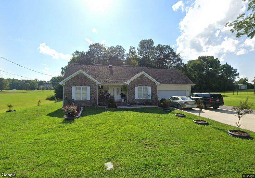
1910 Lasseter Rd Gadsden, AL 35907
Estimated Value: $229,606 - $266,000
3
Beds
2
Baths
1,556
Sq Ft
$161/Sq Ft
Est. Value
About This Home
This home is located at 1910 Lasseter Rd, Gadsden, AL 35907 and is currently estimated at $249,902, approximately $160 per square foot. 1910 Lasseter Rd is a home located in Etowah County with nearby schools including Southside Elementary School, Southside High School, and Rainbow Middle School.
Ownership History
Date
Name
Owned For
Owner Type
Purchase Details
Closed on
Mar 31, 2017
Sold by
Brackett Joel Scott and Brackett Katie D
Bought by
Patterson Jennifer M and Patterson Wesley J
Current Estimated Value
Purchase Details
Closed on
Jun 21, 2016
Sold by
Brackett Katie D and Brackett Joel S
Bought by
Brackett Katie D and Brackett Joel Scott
Home Financials for this Owner
Home Financials are based on the most recent Mortgage that was taken out on this home.
Original Mortgage
$128,000
Interest Rate
3.57%
Create a Home Valuation Report for This Property
The Home Valuation Report is an in-depth analysis detailing your home's value as well as a comparison with similar homes in the area
Home Values in the Area
Average Home Value in this Area
Purchase History
| Date | Buyer | Sale Price | Title Company |
|---|---|---|---|
| Patterson Jennifer M | $129,000 | None Available | |
| Brackett Katie D | -- | -- |
Source: Public Records
Mortgage History
| Date | Status | Borrower | Loan Amount |
|---|---|---|---|
| Previous Owner | Brackett Katie D | $128,000 |
Source: Public Records
Tax History
| Year | Tax Paid | Tax Assessment Tax Assessment Total Assessment is a certain percentage of the fair market value that is determined by local assessors to be the total taxable value of land and additions on the property. | Land | Improvement |
|---|---|---|---|---|
| 2025 | $1,629 | $39,720 | $5,000 | $34,720 |
| 2024 | $1,629 | $39,720 | $5,000 | $34,720 |
| 2023 | $1,629 | $39,720 | $5,000 | $34,720 |
| 2022 | $1,424 | $34,740 | $0 | $0 |
| 2021 | $1,135 | $27,680 | $5,000 | $22,680 |
| 2020 | $1,099 | $26,800 | $0 | $0 |
| 2019 | $1,099 | $26,800 | $0 | $0 |
| 2017 | $467 | $12,580 | $0 | $0 |
| 2016 | $463 | $12,480 | $0 | $0 |
| 2015 | $463 | $0 | $0 | $0 |
| 2013 | -- | $13,080 | $0 | $0 |
Source: Public Records
Map
Nearby Homes
- 1383 Lasseter Rd
- 3270 Hall Dr
- 3090 Pilgrims Rest Rd
- 3485 Fowlers Ferry Rd N
- 1310 Holiday Dr
- 3121 Hawthorne Cir
- 2615 Country Rd
- 2753 Scott St
- 2651 Powell St
- 14.87 Fowlers Ferry Rd S
- 2612 Robertson St E
- 2283 Fowlers Ferry Rd
- 2801 Shady Ln W
- 1 Berkley Hills Dr W
- 2400 Summerchase Dr
- 0 Bridge Point Rd
- 114 Arling Place
- 1.77 Gatewood Trail
- 911 Sibert Cir
- 400 Montclair Dr
- 1886 Lasseter Rd
- 1840 Lasseter Rd
- 1820 Lasseter Rd
- 1830 Lasseter Rd
- 1815 Ben Clough Ln
- 1805 Ben Clough Ln
- 1810 Lasseter Rd
- 1799 Ben Clough Ln
- 1806 Ben Clough Ln
- 1784 Lasseter Rd
- 1795 Ben Clough Ln
- 1798 Ben Clough Ln
- 3669 Hall Dr
- 1792 Ben Clough Ln
- 3675 Hall Dr
- 1920 Lasseter Rd
- 3657 Hall Dr
- 3645 Hall Dr
- 3627 Hall Dr
- 3637 Hall Dr
Your Personal Tour Guide
Ask me questions while you tour the home.